
Illinois, Indiana, Ohio and Michigan Including Chicago, Indianapolis and Columbus Under Level 3 Enhanced Risk With Large Hail and Isolated Tornado Threat Thursday
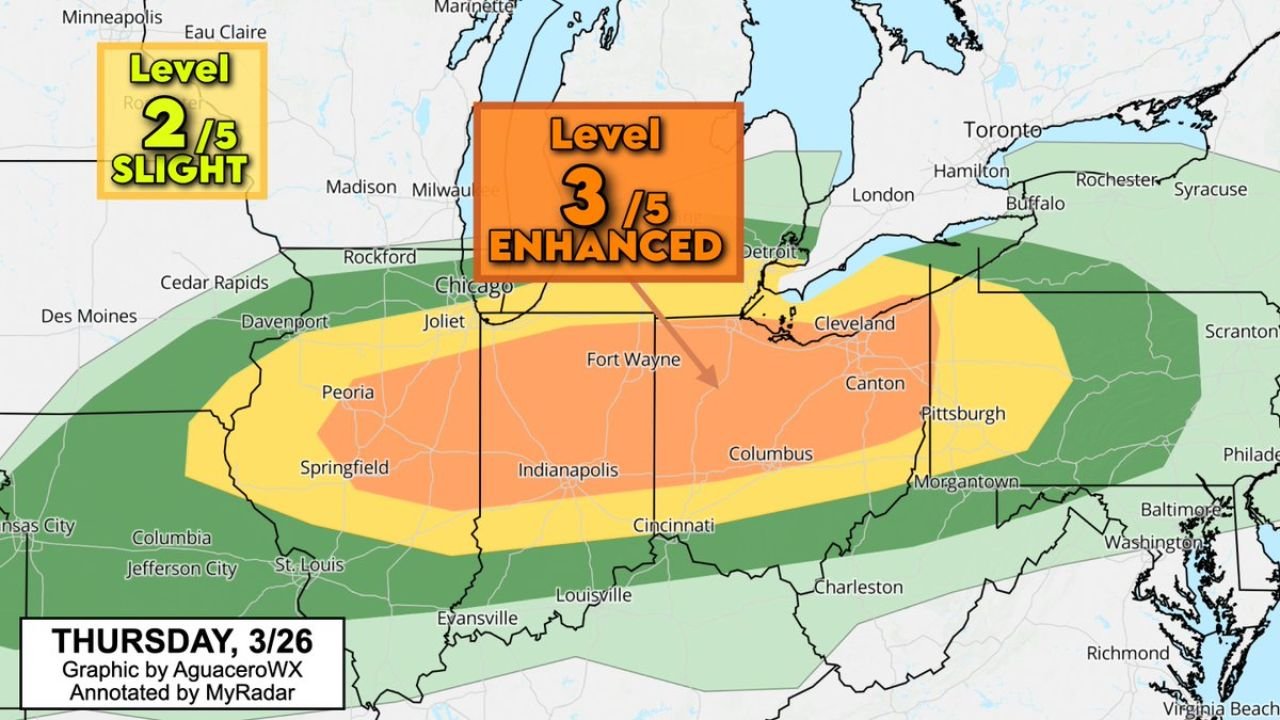
OHIO VALLEY — A Level 3 out of 5 Enhanced Risk for severe weather has expanded eastward, now covering large parts of Illinois, Indiana, Ohio, and southern Michigan, setting the stage for dangerous storms Thursday.
Enhanced Risk Zone Expands Into Ohio and Michigan
The core of the severe weather threat stretches from central Illinois through Indiana into much of Ohio and extends into southern Michigan, including major cities like Chicago, Indianapolis, Columbus, and Detroit.
This expansion signals increasing confidence in a more widespread severe weather event, with the highest impacts expected within this corridor.
Surrounding areas, including parts of Missouri, Kentucky, and Pennsylvania, fall under a lower but still notable risk for strong storms.
Large Hail Threat Increasing Across the Region
One of the most concerning aspects of this setup is the growing potential for large hail, possibly exceeding golf ball size in some storms.
These hail-producing storms are expected to develop within the enhanced risk zone, where atmospheric conditions support strong updrafts capable of sustaining large hailstones.
Damage to vehicles, roofs, and outdoor property will be possible in areas that experience the strongest storms.
Damaging Winds and Isolated Tornado Risk
In addition to hail, storms are expected to produce damaging wind gusts, which could lead to downed trees and power outages across impacted areas.
There is also a risk of isolated tornadoes, particularly within the enhanced risk region where storm organization may become more intense.
While tornado potential is not widespread, any tornado that develops could be strong and fast-moving, requiring close monitoring.
Timing Focused on Thursday Afternoon and Evening
Storms are expected to develop Thursday afternoon and continue into the evening hours, with peak intensity likely during the late-day period.
This timing increases the risk for travel disruptions and rapidly changing conditions, especially during busy afternoon and evening hours.
Residents should remain alert as storms may intensify quickly once they form.
A High-Impact Severe Weather Setup Developing
This setup reflects a classic spring severe weather pattern, where warm, unstable air interacts with a strong system moving across the Midwest and Ohio Valley.
With multiple hazards including large hail, damaging winds, and isolated tornadoes, this event has the potential to bring significant impacts across several states.
Residents across Illinois, Indiana, Ohio, and Michigan are urged to stay weather-aware, monitor warnings, and be ready to take action if severe weather approaches.
Residents are encouraged to share conditions in their area and stay updated with the latest alerts on Waldronnews.com.