
Oklahoma, Kansas and Texas Heat Surges Past 100 Degrees While Illinois, Indiana and Ohio Face Severe Storms and Northern Plains Freeze
UNITED STATES — A dramatic and dangerous weather contrast is unfolding across the country, with triple-digit heat in the Southern Plains, severe storms across the Midwest and Ohio Valley, and near-freezing temperatures in the Northern Plains all occurring at the same time.
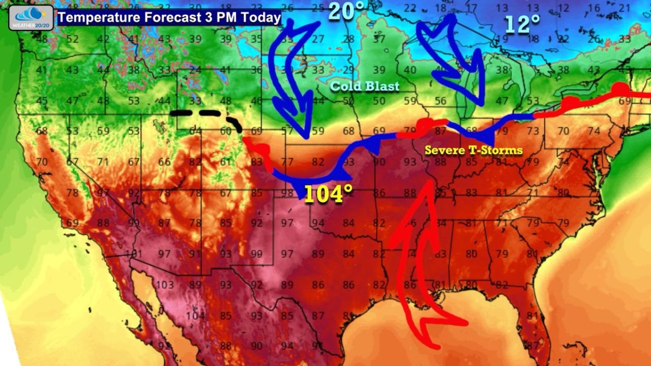
Triple-Digit Heat Builds Across Oklahoma, Texas and Kansas
Temperatures are soaring across the Southern Plains, with parts of northwest Oklahoma reaching around 104 degrees this afternoon.
Nearby areas across Texas and Kansas are also experiencing intense heat, with widespread readings in the 90s and even near 100 degrees, far above seasonal averages for late March.
Cities like Kansas City are expected to approach 90 degrees, highlighting just how extreme this warm surge has become.
This level of heat is highly unusual for this time of year and is being fueled by a strong warm air mass dominating the southern half of the country.
Cold Air Crashes South Across Northern Plains and Upper Midwest
At the same time, a blast of cold air is pushing southward across the Northern Plains and Upper Midwest.
Temperatures are dropping into the teens and 20s near the U.S.-Canada border, including areas of North Dakota and Minnesota, creating a sharp contrast with the heat just to the south.
This cold air mass is driving a powerful front that is now colliding with the warm air across the central United States.
Severe Thunderstorms Expected From Illinois to Ohio
Along this clash zone, severe weather is expected to develop from Illinois through Indiana into Ohio, including cities like Chicago, Indianapolis, and Columbus.
This boundary between hot and cold air is providing the energy needed for strong to severe thunderstorms, which may include damaging winds, hail, and isolated tornadoes.
The setup is classic for spring, where sharp temperature contrasts often lead to intense storm development along frontal boundaries.
Rocky Mountains Continue Snowpack Decline
Meanwhile, the Rocky Mountain region, including parts of Colorado and Utah, continues to experience ongoing snowmelt due to persistent warmth.
Snowpack levels remain extremely low in some areas, contributing to long-term drought concerns and reduced water availability heading into the warmer months.
This adds another layer of concern as the broader weather pattern remains warm and dry across the western United States.
A Nationwide Weather Clash Driving Extreme Conditions
This setup represents a large-scale weather collision, where extreme heat, cold air, and severe storms are all interacting across different regions of the country.
The sharp temperature gradient—from near freezing in the north to over 100 degrees in the south—is fueling instability and helping storms intensify.
This type of pattern is often associated with high-impact weather events during the spring transition season.
Residents across impacted regions are urged to stay weather-aware as conditions evolve rapidly. Share what you’re experiencing in your area and stay updated with the latest coverage on Waldronnews.com.