
Storm Activity Misses ArkLaTex Target as Severe Weather Shifts East Into Indiana, Ohio, Challenging Long-Range Forecast
UNITED STATES — A widely discussed long-range severe weather forecast issued earlier this year did not fully verify as expected, with storm activity during mid-March shifting significantly east of its projected zone and largely bypassing the ArkLaTex region altogether.
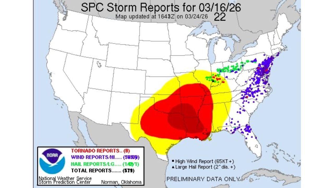
Analysis of observed storm reports from March 16, 2026 shows that the bulk of severe weather impacts occurred across parts of the Ohio Valley and eastern Midwest, rather than the originally highlighted corridor centered over Texas, Louisiana, Arkansas, and Oklahoma.
Forecast Target Focused on ArkLaTex Region
The earlier 45-day outlook had identified a broad high-risk zone stretching from north Texas through Louisiana, Arkansas, and into Mississippi, suggesting that this region would be the primary hotspot for severe weather activity during the mid-March timeframe.
This area — commonly referred to as the ArkLaTex — was forecast to see the most concentrated storm development, including the potential for higher-end severe weather.
Actual Storm Reports Shift Farther East
However, observed data tells a different story.
Storm reports indicate that the majority of severe weather events developed well to the east, with clusters of activity focused across:
- Indiana, particularly southwestern portions
- Ohio Valley region
- Portions of the Mid-Atlantic and Northeast
These areas saw the highest concentration of wind, hail, and other severe weather reports, while the ArkLaTex region experienced little to no comparable activity during this period.
Limited Overlap in Southwest Indiana
One of the few areas where forecast and reality briefly aligned was in southwest Indiana, where some overlap occurred between the projected risk zone and actual storm activity.
However, this overlap was relatively small compared to the overall displacement of severe weather toward the east.
No Significant Activity in ArkLaTex Region
Perhaps the most notable outcome was the lack of meaningful severe weather in the ArkLaTex region, despite it being highlighted as the core area of concern in the long-range forecast.
This absence underscores how atmospheric patterns can shift in ways that significantly alter where storms ultimately develop.
Why the Shift Matters
Severe weather forecasting, especially on extended timescales like 45 days, carries inherent uncertainty. Small changes in atmospheric patterns — such as the position of jet streams, moisture availability, or frontal boundaries — can lead to large shifts in where storms form.
In this case, those factors appear to have favored storm development farther east than originally anticipated.
What This Means Moving Forward
While long-range forecasts can provide useful guidance on general patterns, this event highlights the importance of monitoring short-term and real-time forecasts as conditions evolve closer to an event.
Forecast accuracy typically improves significantly within a few days of an event, when key atmospheric details become clearer.
Waldron News will continue tracking severe weather trends and forecast performance as the spring storm season progresses across the United States.