
Kansas City, Missouri at Center of Evening Storm Threat as Cold Front Collides With 100° Heat and Triggers Hail Risk After Sunset
KANSAS CITY, MISSOURI — A volatile weather setup is developing across the central United States this evening, with thunderstorms expected to form near and around Kansas City shortly after sunset, bringing the potential for large hail and rapidly changing conditions.
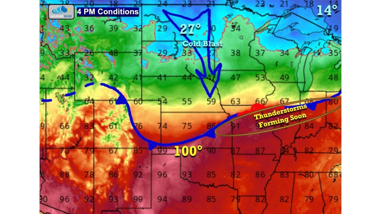
The setup is being driven by a southward-moving cold front colliding with intense early-season heat, creating a sharp contrast in temperatures and an environment favorable for storm development.
100-Degree Heat Meets Incoming Cold Front
Temperature data shows extreme warmth across the southern Plains, with readings near 100°F across parts of Kansas and Oklahoma, while much cooler air is pushing south from the northern Plains and Upper Midwest.
This boundary — where hot and cool air meet — is currently draped across the region and slowly sagging southward. As it does, winds are expected to shift to the north, signaling the arrival of cooler air and helping to trigger thunderstorm development.
Storms Expected Near Kansas City After Sunset
The highest likelihood for storm initiation is focused near the Kansas City metro area, where the frontal boundary intersects with warm, unstable air.
Timing suggests:
- Storms may begin forming near or shortly after sunset
- Initial storms could be isolated but strong
- Activity may expand or organize as the evening progresses
This early phase of storm development is when the greatest hail threat typically occurs.
Large Hail Possible With First Storms
The first thunderstorms that develop in this environment could produce large hail, as atmospheric conditions support strong updrafts capable of suspending and growing hailstones.
While widespread severe weather is not guaranteed, localized strong storms could quickly become intense, especially during the initial stages of development.
Cold Air Surge Driving Rapid Changes
Behind the front, significantly cooler air is advancing southward, with temperatures dropping sharply across the northern Plains.
This “cold blast” is helping to reinforce the boundary and increase the contrast between air masses — a key ingredient for storm formation.
As the front continues to push south, it will gradually undercut the warm air, potentially limiting storm intensity later in the evening but still allowing for an active period during the transition.
Additional Factors Across the Region
In addition to the storm setup, conditions across parts of the central U.S. remain very dry, particularly in areas like Nebraska, where wildfire activity has been noted. Smoke from these fires has already spread into nearby regions, including parts of Colorado.
While not directly tied to storm development, these dry conditions highlight the broader weather pattern influencing the region.
What to Expect This Evening
Residents in and around Kansas City should be prepared for:
- Thunderstorm development after sunset
- Potential for large hail with early storms
- Rapid shifts in wind direction and temperature as the front moves through
Conditions may change quickly, especially during the initial storm development phase.
Waldron News will continue monitoring this evolving situation and provide updates as thunderstorms begin to form across the Kansas City region this evening.