
Hawaii Flood Disaster Returns as Multi-Day Kona Storm Triggers Widespread Flash Flooding Across Islands from March 19 to 24
HAWAII — Significant flooding once again swept across the Hawaiian Islands between March 19 and March 24, 2026, as a renewed surge of tropical moisture combined with unstable atmospheric conditions to produce intense rainfall and dangerous flash flooding statewide.
The multi-day event comes just days after an earlier powerful kona storm had already drenched the region, leaving the ground saturated and highly vulnerable to rapid runoff.
Saturated Ground Set the Stage for Disaster
Leading up to the flooding event, Hawaii experienced repeated rounds of heavy rain and damaging winds from March 10 through March 16, associated with a strong kona storm system.
That earlier system:
- Set multiple rainfall records across the islands
- Fully saturated soils statewide
- Left rivers, streams, and drainage systems already stressed
By the time the next system arrived, even moderate rainfall had the potential to trigger immediate flooding.
Flooding Returned as Moisture Surged Back Over the Islands
Between March 19 and March 24, conditions quickly deteriorated again as a surface low pressure system pulled deep tropical moisture back across the region, particularly affecting areas near and just south of the Big Island.
This renewed influx of moisture led to:
- Persistent rounds of heavy rain
- Thunderstorms capable of producing intense rainfall rates
- Rapid accumulation of water in already saturated areas
Upper-Level Instability Fueled Intense Rainfall Bands
An upper-level trough moving through the region added further instability, allowing clusters of heavy showers and thunderstorms to develop.
These storms produced:
- Very high rainfall rates in short periods
- Repeated downpours over the same locations
- Increased risk of flash flooding in vulnerable terrain
The combination of tropical moisture and atmospheric lift created near-ideal conditions for widespread flooding.
Slow-Moving System Increased Flash Flood Risk
A key factor in the severity of the event was a slow-moving trough, which allowed storms to linger over the same areas for extended periods.
This led to:
- Continuous rainfall over already saturated ground
- Rapid runoff into rivers and low-lying areas
- Elevated flash flood risk, especially across Oahu and areas eastward
Even though rainfall coverage was somewhat less widespread than the earlier kona storm, the impacts were more severe due to ground conditions.
Why This Event Became So Dangerous
Despite being slightly weaker in overall atmospheric strength than the previous storm, this event caused more significant flooding impacts because:
- Soil saturation reduced absorption capacity
- Less rainfall was needed to trigger flooding
- Water runoff occurred much faster than normal
This created a dangerous situation where flooding developed quickly, even in areas that might not typically flood.
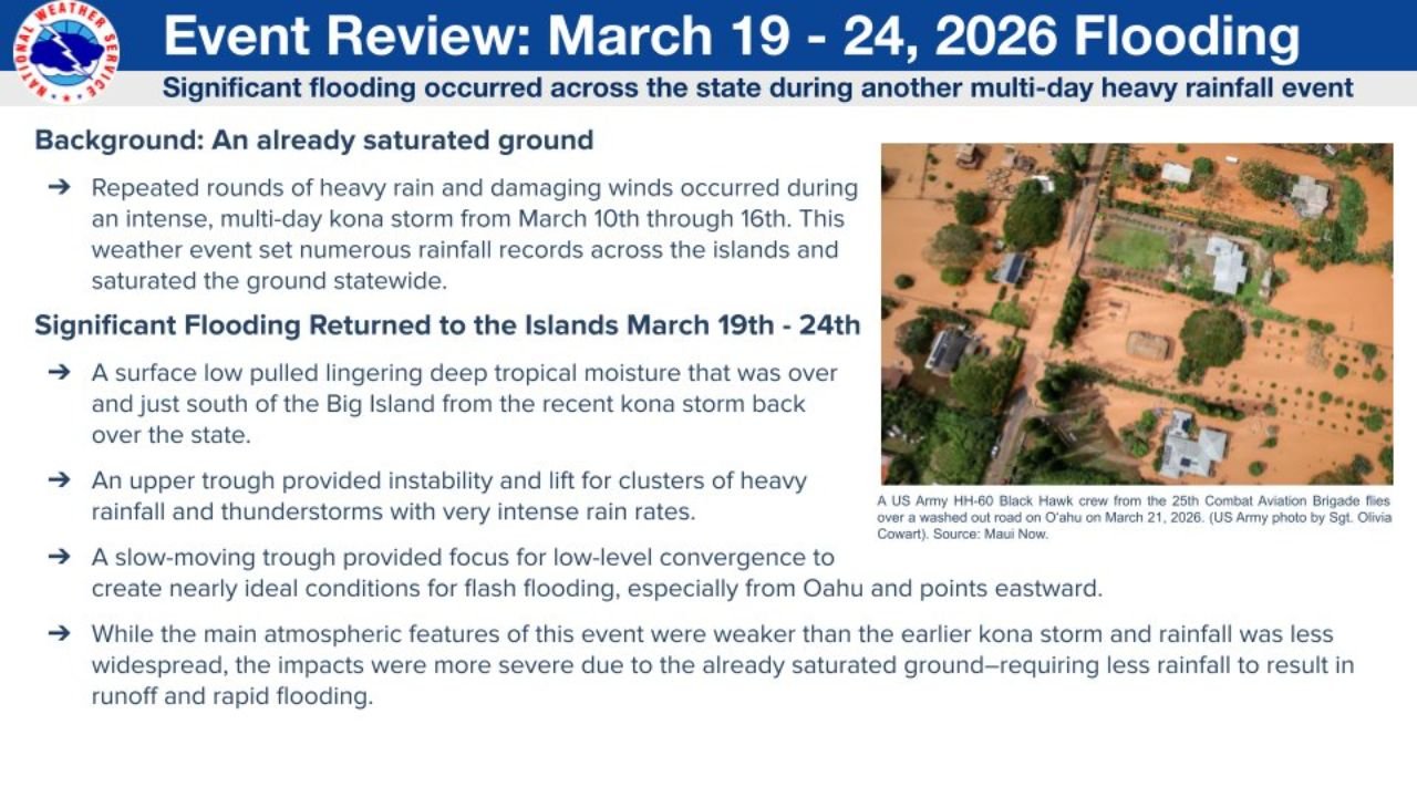
Widespread Impacts Across the Islands
Flooding impacts were reported across multiple islands, including:
- Washed-out roads and infrastructure damage
- Flooded neighborhoods and low-lying communities
- Disruptions to transportation and daily life
Emergency response efforts were required in several areas as conditions deteriorated rapidly.
What Comes Next
With back-to-back heavy rainfall events already impacting Hawaii, attention now turns to:
- Whether additional systems will affect the region
- How quickly soils can recover and dry out
- The potential for continued flood risks in the coming weeks
Residents are urged to remain alert, especially in flood-prone areas, as even minor rainfall could still trigger additional flooding.
Waldron News will continue to monitor conditions across Hawaii and provide updates as more information becomes available.