
March Cold Front Clears the East as Above-Normal Warmth, Severe Storms and Heavy Rain Target the Plains, Ohio Valley and Northeast From Missouri to Virginia Next Week
UNITED STATES — The last eastern cold shot of March is winding down across the eastern United States, bringing general thunderstorms today under weak atmospheric conditions. But a rapid and significant pattern change is already taking shape behind this departing front — one that will deliver well above-average warmth from the Plains to the Northeast, followed by increasing threats of severe thunderstorms and heavy rainfall across a corridor stretching from Missouri, Illinois and Indiana through Kentucky, Tennessee, Ohio, West Virginia, Virginia and Pennsylvania heading into early April.
Two Gulf of Alaska low-pressure systems are the key drivers of this transition, with the first arriving this weekend and a second following next weekend — together reshaping the entire country’s weather pattern through at least the first week of April.
States and Regions in the Evolving Weather Zone
This developing pattern affects virtually the entire continental United States, with distinct impacts by region and timing:
Above-Normal Warmth — Monday through Wednesday:
- Kansas, Nebraska, Missouri — warmth builds across the central Plains
- Illinois, Indiana, Ohio — above-average temperatures spreading east
- Pennsylvania, New York, New Jersey — warmth extending into the Northeast mid-week
- Virginia, West Virginia, Maryland — above-normal readings across the Mid-Atlantic
Severe Weather Risk — Tuesday and Friday:
- Missouri, Illinois, Indiana — primary severe weather corridor Tuesday
- Kentucky, Tennessee — elevated storm threat both Tuesday and Friday
- Ohio, West Virginia — significant severe potential as warm moist air meets incoming trough
- Virginia, Pennsylvania — eastern fringe of the severe weather zone
Heavy Rainfall — through Saturday, April 4:
- Missouri, Illinois, Indiana — 1.4 to 2.0 inches of rainfall expected
- Ohio, Kentucky, West Virginia — highest accumulation zone, 1.7 to 2.5 inches
- Virginia, Pennsylvania, Maryland — 1.5 to 2.3 inches across the Mid-Atlantic corridor
- Texas, Oklahoma — 0.3 to 0.9 inches on the southern fringe
- Isolated maximum of up to 4.60 inches possible in heaviest cells (NOAA Blend of Models)
Primary Threats in the Days Ahead
Forecasters are highlighting a developing multi-day hazard picture across the United States:
- Today — General thunderstorms along the departing cold front, limited severe potential under weak atmospheric conditions — don’t expect much from this system
- Monday through Wednesday — Way above-average warmth building from Kansas and Nebraska east through Ohio, Pennsylvania and New York
- Next Tuesday — First significant severe weather window opens across Missouri, Illinois, Kentucky and Ohio — timing has wiggle room as features are still several days out
- Through April 4 — Heavy rainfall spreading across Indiana, Ohio, West Virginia, Virginia and Pennsylvania with NOAA showing a maximum accumulation of 4.60 inches
- Next Friday — Second severe weather window as the follow-up Gulf of Alaska trough carves through — SPC outlooks in the days 4–8 range possible once confidence builds
- NBM guidance has notably lowered rainfall totals today over areas not in the worst drought shape — particularly across parts of Tennessee and the Carolinas
Why Two Gulf of Alaska Lows Are Driving Everything
The entire pattern change traces back to back-to-back Gulf of Alaska low-pressure systems. The first drops south this weekend, beating down the stubborn ridge that has been responsible for the anomalous heat across California, Nevada and Arizona. This ends the extreme western heat but simultaneously allows warmth to surge northward and eastward across the Plains and Ohio Valley ahead of the trough.
The second Gulf of Alaska low then follows next weekend, carving out a deeper trough across the country and creating the atmospheric setup needed for the most significant severe weather and heavy rainfall potential of the entire stretch. The combination of these two systems transitions the country from a late-winter cold pattern to a fully active early-spring severe weather pattern within roughly 10 days.
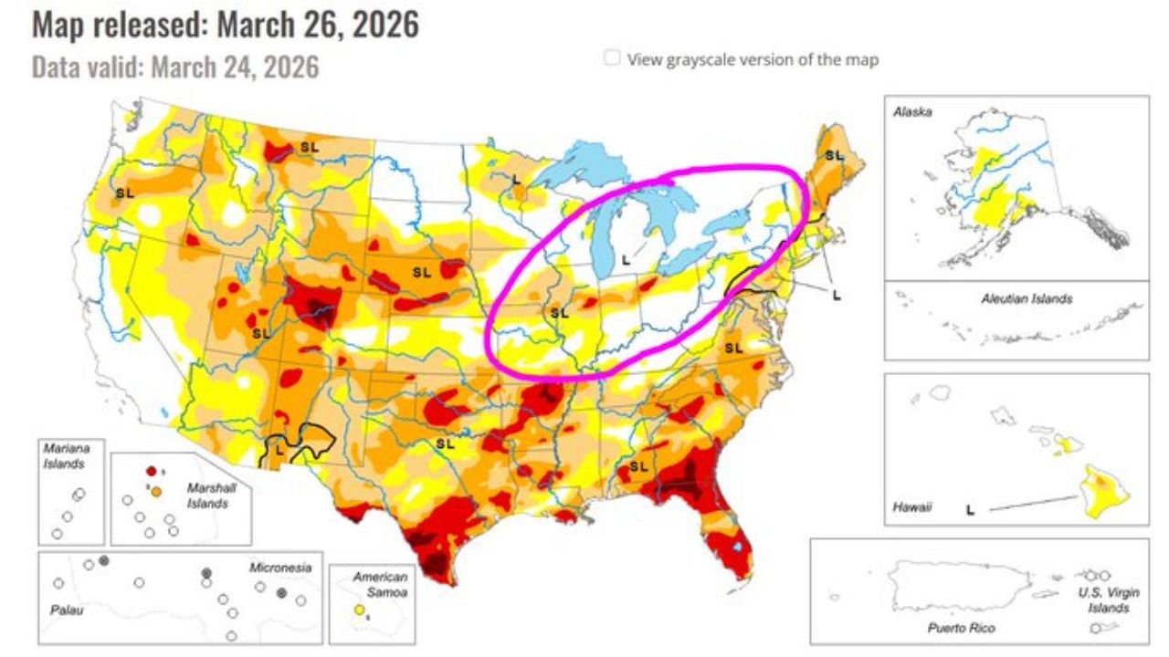
The US Drought Monitor released March 26, 2026 — valid through March 24 — shows that much of Texas, Oklahoma, Kansas and the Southeast remain in significant drought, meaning heavy rainfall across Missouri, Indiana, Ohio and West Virginia will be welcomed. However, the circled region across the Great Lakes and Ohio Valley is in comparatively better moisture shape than surrounding areas.
Multi-Day Pattern: Wetter and More Active Through Early April
The overall weather story for the United States heading into early April is a clear and decisive shift toward a wetter and more active pattern. States from Missouri and Illinois eastward through Ohio, Kentucky, West Virginia, Virginia and Pennsylvania face the most significant combined threat of severe weather and heavy rainfall. The NBM guidance has tempered some earlier optimism about drought relief in areas like Tennessee, Alabama and the Carolinas, but the core rainfall corridor across the Ohio Valley and Mid-Atlantic remains intact.
Residents and emergency managers across Indiana, Ohio, West Virginia, Virginia and Pennsylvania in particular should begin monitoring forecast updates closely as the severe weather and flooding potential increases heading into Tuesday.
What to Watch Next
As this major pattern shift continues to develop, key details to monitor include:
- Tuesday severe weather outlook — whether Missouri, Illinois, Indiana and Ohio receive SPC day-1 or day-2 coverage
- Rainfall totals across Ohio, West Virginia, Virginia and Pennsylvania as the heaviest precipitation corridor takes shape
- Second severe weather window Friday — timing and which states fall under the greatest threat
- Second Gulf of Alaska low arrival next weekend and how aggressively it carves the trough
- NBM and NOAA model trends — watch for totals to be revised upward or downward over Tennessee, Kentucky and the Carolinas
- Flood potential in low-lying areas of West Virginia, Kentucky and southern Ohio if rainfall totals trend toward the higher end of forecasts
Residents across Missouri, Illinois, Indiana, Ohio, Kentucky, West Virginia, Virginia, Pennsylvania and Maryland should have severe weather safety plans in place and ensure weather alerts are enabled on mobile devices well ahead of Tuesday’s potential severe weather window.
WaldronNews.com will continue tracking this multi-state pattern change and provide state-specific updates on severe weather timing, rainfall totals and flood potential as confidence increases heading into next week.