
28 Small Earthquakes Rattle Pāʻauilo and the Hāmākua Coast of Hawaiʻi Island Near Mauna Kea — USGS Says No Volcanic Threat
PĀʻAUILO, HAWAIʻI — A notable cluster of 28 small tectonic earthquakes struck near Pāʻauilo on the Hāmākua coast of the Island of Hawaiʻi on March 26, 2026, drawing attention from residents and scientists across the Big Island. The earthquakes occurred beneath the northeast side of Mauna Kea, with most registering at depths of 5 to 10 kilometers (approximately 3 to 6 miles) below the surface. The two largest events reached magnitude 3, making them large enough to be felt by residents in the immediate area.
The Hawaiian Volcano Observatory (HVO) of the USGS is closely monitoring the situation and has confirmed the cluster is being tracked in real time. Updates will be posted as needed at volcanoes.usgs.gov.
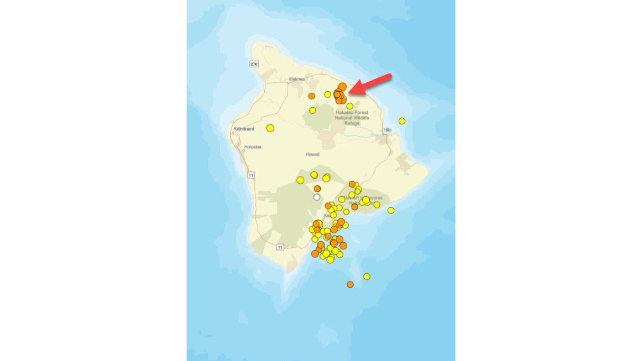
Location of the Earthquake Cluster — Hāmākua Coast, Island of Hawaiʻi
The earthquake activity is concentrated in a specific zone on the Big Island of Hawaiʻi:
- Pāʻauilo, Hawaiʻi — the community nearest the earthquake cluster on the Hāmākua coast
- Hāmākua coast — the northeast-facing coastline of the Island of Hawaiʻi, known for dramatic sea cliffs and agricultural land
- Northeast flank of Mauna Kea — directly beneath which the 28 earthquakes occurred at 5–10 km depth
- Hakalau Forest National Wildlife Refuge area — the earthquake cluster falls within this broader northeast Big Island zone as shown on the HVO tracking map
- Waimea corridor — the nearest significant town to the northwest of the earthquake zone
- Hilo — the largest city on the Big Island, located to the southeast of the cluster
The HVO weekly earthquake map for the Island of Hawaiʻi shows the Hāmākua cluster marked with a red arrow indicating it as the primary point of interest, distinct from the separate and unrelated earthquake activity visible in the southern portion of the island near Kīlauea.
Primary Facts About the Earthquake Cluster
The Hawaiian Volcano Observatory has provided the following key details about the Pāʻauilo earthquake swarm:
- 28 small tectonic earthquakes occurred on March 26, 2026
- All events located beneath the northeast side of Mauna Kea
- Depths ranged from 5 to 10 km (3 to 6 miles) — shallow tectonic events
- Largest two earthquakes reached magnitude 3 — potentially felt by nearby residents
- Not related to magma movement — confirmed by HVO
- Caused by stress release within the edifice of Kohala volcano, which underlies Mauna Kea
- Kohala volcano is not active — this is a dormant volcanic structure, not a sign of reawakening
Why These Earthquakes Are Not a Volcanic Threat
The USGS Hawaiian Volcano Observatory is emphatic that these events pose no volcanic threat to the Island of Hawaiʻi. The earthquakes are purely tectonic in origin — meaning they are caused by the release of stress and strain within the rock structure of the volcanic edifice, not by any movement of magma beneath the surface.
Kohala volcano, which underlies Mauna Kea on the northern Big Island, is the oldest of the five volcanoes that make up the Island of Hawaiʻi and has been dormant for approximately 60,000 years. Stress release earthquakes within dormant volcanic structures like Kohala are well-documented and have occurred in similar clusters in the past. The HVO notes these events are similar to past earthquake clusters recorded in the same area — a reassuring comparison that places the current swarm firmly within the range of normal geological activity for this part of the Big Island.
The separate cluster of earthquakes visible in the southern portion of the Island of Hawaiʻi on the HVO map — near Kīlauea and the southeastern flank — is unrelated to the Hāmākua coast swarm and reflects the ongoing seismic activity associated with Kīlauea volcano’s active volcanic system.
Multi-Day Pattern: Monitoring Continues
The Hawaiian Volcano Observatory has stated it is closely monitoring the Pāʻauilo earthquake cluster and will post updates as the situation develops. While the current assessment is reassuring — no magma movement, no volcanic threat — the HVO will continue tracking any additional seismic activity along the Hāmākua coast and beneath Mauna Kea in the days ahead.
Residents of Pāʻauilo, Waimea and the broader Hāmākua coast should not be alarmed by the cluster but are encouraged to stay informed through official HVO and USGS updates.
What to Watch Next
Key details to monitor as this cluster evolves:
- Additional earthquake activity near Pāʻauilo and the Hāmākua coast
- HVO updates at volcanoes.usgs.gov for any changes in assessment
- Magnitude trends — whether the largest events remain at magnitude 3 or if any larger events occur
- Depth changes — any significant shallowing of earthquake depths would warrant closer attention
- HVO weekly earthquake map updates for the Island of Hawaiʻi tracking any expansion of the cluster zone
Residents across the Hāmākua coast, Waimea and Hilo areas of the Island of Hawaiʻi can monitor the latest earthquake activity directly through the USGS Hawaiian Volcano Observatory at volcanoes.usgs.gov/hans-public/.
WaldronNews.com will continue tracking seismic activity on the Island of Hawaiʻi and provide updates if the assessment from HVO changes in the days ahead.