
San Francisco Bay Area and Northern California Face a “Boom or Bust” Rainfall Setup — Cooler Temperatures Certain as Pattern Change Targets Tuesday Through Thursday Night
SAN FRANCISCO, CALIFORNIA — A significant pattern change is on tap for Northern California and the San Francisco Bay Area heading into the early part of next week, with cooler temperatures confirmed and a critical rainfall question hanging over the region. The National Weather Service San Francisco Bay Area office has laid out a stark “boom or bust” rainfall scenario for the period of Tuesday through Thursday night — meaning the difference between a meaningful soaking and a largely dry event comes down entirely to the strength of the incoming trough. What is certain: the heat is ending. What remains uncertain: whether the rain delivers.
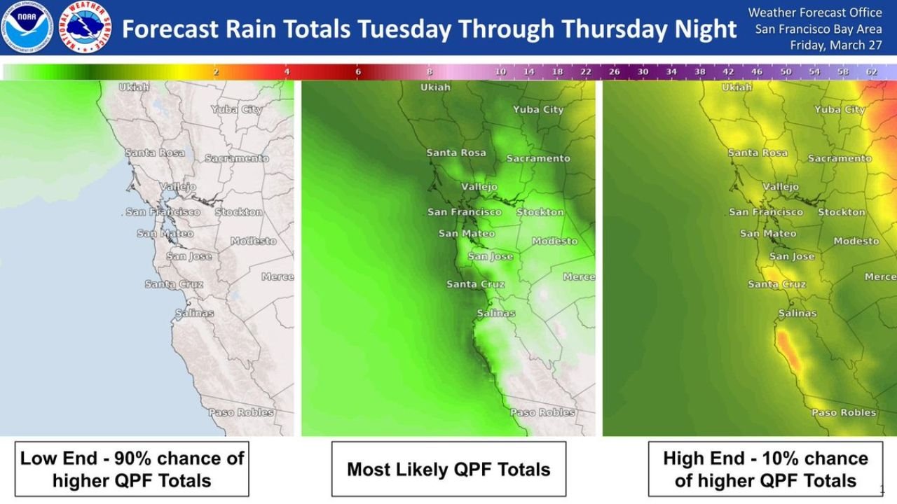
The NWS forecast rain probability maps, issued Friday, March 27, show three dramatically different outcomes for San Francisco, San Jose, Santa Rosa, Sacramento and surrounding communities — making this one of the most uncertain forecast setups of the season so far for California.
Cities and Areas in the Forecast Zone
The rainfall uncertainty and pattern change affects communities across a wide swath of Northern California:
- San Francisco — directly in the primary forecast zone for Tuesday–Thursday rainfall
- San Jose and San Mateo — South Bay communities facing the same boom-or-bust rainfall question
- Santa Rosa and Ukiah — North Bay communities where higher-end totals could be most significant
- Sacramento and Stockton — Central Valley cities on the eastern fringe of the forecast zone
- Vallejo and Modesto — inland Bay Area communities within the QPF uncertainty corridor
- Santa Cruz and Salinas — coastal communities south of San Francisco in the forecast zone
- Yuba City and Merce — northern and central valley communities watching the trough strength closely
- Paso Robles — southern extent of the NWS San Francisco Bay Area forecast zone
Three Possible Rainfall Outcomes — Tuesday Through Thursday Night
The NWS San Francisco Bay Area has issued an unusual three-scenario forecast map for the Tuesday through Thursday night period, highlighting the extraordinary uncertainty in this setup:
Low End — 90% chance of exceeding this amount:
- Minimal rainfall across San Francisco, San Jose and the Bay Area
- Light green signal on the NWS map — very light totals at best
- This is the floor — 9 out of 10 outcomes produce at least this much rain
Most Likely QPF Totals:
- Moderate green coverage expanding across the Bay Area, Santa Cruz, Salinas and North Bay
- San Francisco, San Jose, Santa Rosa and Vallejo all receiving meaningful rainfall
- This is the forecaster’s best estimate for how the trough performs
High End — 10% chance of exceeding this amount:
- Significantly heavier rainfall across the entire Northern California forecast zone
- Red and orange hotspots developing near Ukiah, Santa Cruz and the coastal ranges south toward Paso Robles
- Sacramento, Stockton and Modesto seeing much heavier totals in this scenario
- This is the ceiling — only 1 in 10 outcomes reaches this level
Why This Is a “Boom or Bust” Scenario for California
The core uncertainty in this forecast is the strength of the incoming trough. A stronger, more amplified trough will tap into deeper Pacific moisture and deliver a significant soaking across San Francisco, San Jose and Northern California. A weaker, more progressive trough will slide through quickly without wringing out meaningful rainfall — leaving the region largely dry despite the cooler temperatures.
Cooler temperatures are not uncertain — they are arriving regardless of the rainfall outcome. The pattern change will end the warm, above-normal stretch that has dominated California and bring San Francisco, San Jose, Santa Rosa and Sacramento back toward seasonal norms by early next week. But whether residents in San Francisco and the Bay Area wake up to meaningful rainfall totals Tuesday through Thursday — or a mostly dry cool-down — depends on how aggressively the trough develops over the weekend and into early next week.
Multi-Day Pattern: Monitoring Trough Strength Through the Weekend
The NWS San Francisco Bay Area is urging residents to check back for updated forecasts through the weekend as model confidence increases. The trough’s strength will become clearer as it approaches — and with it, which of the three rainfall scenarios San Francisco, San Jose and Northern California actually experience. The high-end scenario would be particularly impactful across Ukiah and the coastal ranges, where the NWS maps show the potential for significantly elevated totals if the trough performs at its ceiling.
What to Watch Next
As this uncertain pattern change develops, key details to monitor include:
- Trough strength signals in weekend model runs — the critical variable for rainfall outcomes
- NWS San Francisco QPF updates — watch for the three-scenario spread to narrow through Saturday and Sunday
- Tuesday onset timing — whether rain arrives early Tuesday or later in the day across San Francisco and the Bay Area
- High-end scenario triggers — particularly for Ukiah, Santa Cruz and coastal ranges where the heaviest totals are possible
- Sacramento and Stockton — Central Valley rainfall outcomes depend heavily on whether the trough reaches its higher-end potential
- Thursday night cutoff — whether the rain event wraps up cleanly or lingers into the following weekend
Residents across San Francisco, San Jose, Santa Rosa, Ukiah, Sacramento, Stockton, Santa Cruz, Salinas and Paso Robles should monitor NWS San Francisco Bay Area forecast updates closely through the weekend as confidence in the rainfall outcome improves.
WaldronNews.com will continue tracking this developing Northern California pattern change and provide updated rainfall forecasts for the San Francisco Bay Area as the boom-or-bust setup comes into clearer focus.