
Palm Beach County and Jupiter, Florida Face 74% Rain Chance Overnight Storms Spread South Toward Miami Saturday Night
WEST PALM BEACH, FLORIDA — Scattered showers and a few thunderstorms currently affecting the Everglades and Southwest Florida will dissipate shortly after sunset Saturday, but the overnight threat is far from over for South Florida. The National Weather Service Miami/South Florida office has issued a Saturday night rain chance forecast showing Palm Beach County — including Jupiter at 74% and West Palm Beach at 68% — facing the highest rainfall probabilities in the region. Additional showers and isolated thunderstorms will move into Palm Beach County after midnight and gradually spread south through the metro areas toward Boca Raton, Fort Lauderdale and Miami overnight.
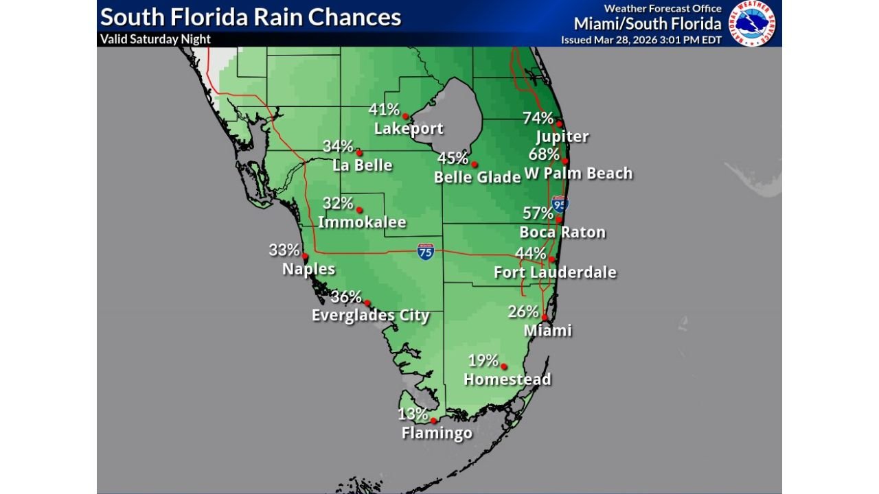
Cities and Rain Chances in the Risk Zone
The NWS Miami Saturday night rain probability forecast, issued March 28, 2026 at 3:01 PM EDT, shows the following rain chances across South Florida:
Palm Beach County — Highest Risk:
- Jupiter: 74% rain chance — highest in South Florida Saturday night
- West Palm Beach: 68% rain chance
- Belle Glade: 45% rain chance
- Boca Raton: 57% rain chance
Broward County:
- Fort Lauderdale: 44% rain chance
Miami-Dade County:
- Miami: 26% rain chance
- Homestead: 19% rain chance
- Flamingo: 13% rain chance — lowest in the region
Interior South Florida:
- Lakeport: 41% rain chance
- La Belle: 34% rain chance
- Immokalee: 32% rain chance
- Naples: 33% rain chance
- Everglades City: 36% rain chance
Primary Threats Saturday Night
The NWS Miami/South Florida forecast highlights the following hazards for the overnight period:
- Showers and isolated thunderstorms moving into Palm Beach County after midnight
- Gradual southward spread of rain into Boca Raton, Fort Lauderdale and the Miami metro through the overnight hours
- 74% rain chance at Jupiter — residents should expect wet conditions through much of the night
- Scattered showers over the Everglades and SW Florida dissipating shortly after sunset — threat shifting northeast
- Localized street flooding possible in low-lying areas of Palm Beach County if thunderstorms produce heavy short-duration rainfall
- Rain chances dropping sharply southward — Miami at only 26% and Flamingo at just 13% by comparison
Why Palm Beach County Faces the Greatest Risk Saturday Night
The setup favoring Palm Beach County and the Jupiter, West Palm Beach and Boca Raton corridor is driven by the timing and track of overnight moisture. The showers and storms initiating over the Everglades and Southwest Florida Saturday afternoon will fade after sunset, but a fresh round of shower and thunderstorm activity will develop and push into Palm Beach County after midnight — following a classic South Florida pattern where overnight marine moisture feeds convective development along the eastern coastline.
Jupiter’s 74% rain chance places it at significantly higher risk than communities just 60 miles to the south, illustrating just how tightly the rain probability gradient runs along the South Florida coastline on Saturday night. Residents in Jupiter, West Palm Beach and Boca Raton should have an umbrella ready and expect wet conditions during the late night and early Sunday morning hours.
The Miami metro, by contrast, sits at only a 26% rain chance — meaning the majority of the overnight storm activity is expected to remain well north of downtown Miami before the system gradually spreads south through the overnight hours.
Multi-Day Pattern: Overnight Rain Clears Into Sunday
The overnight shower and thunderstorm activity associated with Saturday night’s system is expected to gradually push through South Florida and weaken as it moves southward through the Miami-Dade area. Sunday is expected to bring improving conditions across much of the region as the overnight moisture push dissipates, though South Florida’s active late-March pattern means additional shower chances cannot be ruled out during the afternoon heating hours Sunday.
What to Watch Next
Key details to monitor as Saturday night’s system develops:
- Midnight onset timing in Palm Beach County — whether storms arrive earlier or later than forecast
- Southward spreading rate — how quickly the rain pushes from Jupiter and West Palm Beach toward Fort Lauderdale and Miami
- Thunderstorm intensity — whether any isolated storms produce heavy rainfall capable of causing street flooding in Palm Beach County
- Boca Raton at 57% — a significant risk zone sitting between the high-probability Palm Beach corridor and the lower Broward/Miami-Dade numbers
- Fort Lauderdale timing — whether the 44% chance materializes before or after midnight
Residents across Palm Beach County, Jupiter, West Palm Beach, Boca Raton and Fort Lauderdale should keep weather alerts enabled on mobile devices Saturday night and avoid driving through any flooded roadways if heavy rain occurs.
WaldronNews.com will continue tracking this overnight South Florida rain event and provide updates as shower and thunderstorm activity develops across Palm Beach County and the broader South Florida region.