
Oklahoma and Texas Face Rising Storm Chances Mid-Week, Durant Hits 60% Rain Probability as Pattern Change Brings Moisture Back Wednesday Through Saturday
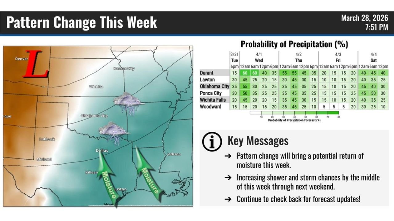
OKLAHOMA CITY, OKLAHOMA — A significant pattern change is underway across Oklahoma and Texas this week, with a returning moisture surge set to fuel increasing shower and thunderstorm chances from the middle of the week through next weekend. The National Weather Service Norman, Oklahoma office issued a forecast Saturday evening showing rain probabilities climbing sharply by Wednesday, April 1 — with Durant leading all cities at 60% by Wednesday morning — and storm chances persisting through Saturday, April 4 across much of the region.
A low-pressure system tracking toward the area from the northwest is the primary driver, pulling Gulf moisture northward into Oklahoma and North Texas from Houston through Dallas and into Oklahoma City and beyond.
Cities and States in the Storm Zone
The NWS Norman precipitation probability forecast covers Oklahoma and North Texas from Tuesday, March 31 through Saturday, April 4:
Oklahoma — Highest Risk:
- Durant: Peak chance of 60% at 12 AM and 6 AM Wednesday — highest in the forecast zone
- Oklahoma City: Up to 55% Wednesday morning, storm chances continuing through the week
- Ponca City: Up to 50% Wednesday morning, with additional chances Friday and Saturday
- Lawton: 45% Wednesday, storm chances spreading through Thursday
- Wichita Falls: 45% Tuesday evening, active pattern through Thursday
- Woodward: Lower probabilities — 45% Thursday evening as the system moves through
Texas — In the Moisture Corridor:
- Dallas: Within the moisture return corridor shown on the NWS pattern change map
- Wichita Falls, Texas: Directly in the precipitation zone with 45% chances Tuesday night
- Lubbock and Midland: On the western fringe of the moisture return
Primary Threats Mid-Week Through the Weekend
The NWS Norman forecast highlights the following hazards across Oklahoma and Texas:
- Wednesday, April 1 — peak storm day with Durant at 60%, Oklahoma City at 55% and Ponca City at 50% rain probability
- Thursday, April 2 — continued active pattern with Durant at 55%, Lawton at 45% and Oklahoma City at 45%
- Shower and thunderstorm chances each day Wednesday through Saturday
- Gulf moisture surge flowing northward from Houston and Dallas into Oklahoma City and Durant
- Low-pressure system dragging a moisture return across the southern Plains
- Saturday, April 4 — storm chances continuing with Durant at 40–45%, Oklahoma City at 40–45% and Ponca City at 45–50%
Why Durant and Southern Oklahoma Face the Highest Risk
Durant, Oklahoma — sitting in Bryan County in southern Oklahoma near the Texas border — faces the highest rain probabilities in the entire forecast zone because of its position directly in the path of the northward-surging Gulf moisture corridor. As the low-pressure system drops toward the region and pulls warm moist air northward from Houston and Dallas, southern Oklahoma communities like Durant are first in line to receive the heaviest moisture return.
The NWS Norman precipitation probability chart shows Durant’s chances spiking to 60% at both 12 AM and 6 AM Wednesday before gradually dropping through the afternoon — a classic overnight and early morning storm pattern associated with a low-level jet stream strengthening after dark across Oklahoma and North Texas.
Oklahoma City follows closely at 55% Wednesday morning, with Ponca City and Lawton also seeing significant chances through the mid-week period.
Multi-Day Pattern: Active Through Next Weekend
The pattern change affecting Oklahoma and Texas is not a one-day event. The NWS Norman forecast shows storm chances persisting from Tuesday, March 31 all the way through Saturday, April 4 — a six-day window of elevated rainfall potential across the region. Saturday shows another round of meaningful chances with Durant at 40%, Oklahoma City at 45%, and Ponca City at 50% — suggesting a second wave of storm activity is possible as the week closes out.
This extended active pattern aligns with the broader national transition underway, as a more energetic early April setup takes hold across the southern Plains, Oklahoma and Texas.
What to Watch Next
Key details to monitor as this pattern change develops:
- Wednesday morning storm timing — whether Durant and Oklahoma City see overnight storms or a delayed morning onset
- Low-pressure track and how aggressively it pulls Gulf moisture into southern Oklahoma
- Thursday storm potential — whether a second round rivals Wednesday’s peak probabilities
- Rainfall totals — NWS updates through the weekend will sharpen accumulation estimates
- Saturday second wave — whether Ponca City and Oklahoma City see 45–50% chances materialize
- Severe weather potential — as moisture returns and instability builds, watch for NWS to add storm severity details to the forecast
Residents across Durant, Oklahoma City, Lawton, Ponca City, Wichita Falls and Woodward should monitor NWS Norman forecast updates closely at weather.gov/norman as confidence increases heading into mid-week.
WaldronNews.com will continue tracking this developing pattern change across Oklahoma and Texas and provide updated storm timing and rainfall information as the week progresses.