
Isolated Storms and Blowing Dust Threaten Southern Arizona and Phoenix Metro This Afternoon Gusty Outflow Winds 35+ mph Possible Across Pinal and Maricopa Counties
PHOENIX, ARIZONA — Isolated showers and thunderstorms are expected to develop across southern Arizona south of I-8 this afternoon and push northeastward through the evening, bringing a multi-hazard threat to communities across Pinal County, southern Maricopa County and southern Gila County. While most storm activity is expected to stay south of the Phoenix metro, the National Weather Service Phoenix warns that strong gusty outflow winds extending far from the storms could generate localized blowing dust well beyond the immediate rainfall area — potentially impacting communities across a much wider zone than the storms themselves.
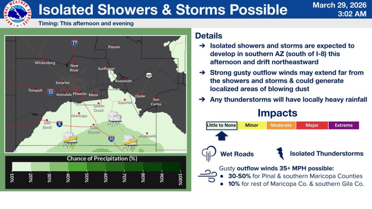
The NWS Phoenix forecast, issued March 29, 2026 at 3:02 AM, places the primary storm development zone across southern Arizona south of I-8, with activity drifting northeastward through the afternoon and evening hours.
Cities and Counties in the Risk Zone
The storm and blowing dust threat affects a corridor across southern and central Arizona:
Primary Storm Zone — South of I-8:
- Maricopa — southern Maricopa County directly in the storm development area
- Casa Grande — within the highest precipitation probability zone
- Mammoth — eastern Pinal County in the storm track corridor
- Gila Bend — southwestern Arizona within the southern storm zone
- Superstition area — Globe and San Carlos corridor on the northeastern storm drift path
Outflow Wind and Blowing Dust Zone:
- Pinal County — 30 to 50% chance of gusty outflow winds exceeding 35 mph
- Southern Maricopa County — 30 to 50% chance of 35+ mph outflow gusts
- Rest of Maricopa County — 10% chance of gusty outflow winds reaching 35+ mph
- Southern Gila County — 10% chance of outflow gusts extending into this area
- Phoenix metro — primary storm activity expected to stay south, but outflow dust possible
Primary Threats This Afternoon and Evening
The NWS Phoenix forecast highlights the following hazards across southern Arizona:
- Isolated showers and thunderstorms developing south of I-8 this afternoon
- Storms drifting northeastward through the evening — tracking toward Pinal County and the Globe/San Carlos corridor
- Gusty outflow winds of 35+ mph — 30 to 50% chance for Pinal and southern Maricopa counties
- Localized blowing dust generated by outflow winds extending far from the storm cores
- Locally heavy rainfall within any thunderstorm cells that develop
- Wet roads — impact level ranging from little to none up to minor across the affected zone
- Isolated thunderstorms — impact level in the minor to moderate range for the southern storm zone
Why Blowing Dust Is the Bigger Threat for the Phoenix Area
While the Phoenix metro is expected to largely escape the direct rainfall from today’s isolated storms, the blowing dust threat is the more insidious hazard for a wider area. Outflow winds — the strong cold downdraft winds that rush outward from thunderstorm bases — can travel far from the parent storm, picking up loose desert soil and generating dangerous dust clouds across southern and central Arizona even in areas where no rain falls.
With a 30 to 50% chance of 35+ mph outflow gusts across Pinal County and southern Maricopa County, drivers on I-8, I-10 and highways across the Pinal County corridor should be alert for rapidly developing dust conditions that can reduce visibility to near zero within seconds. “If you can’t see, pull aside and stay alive” — Arizona’s dust storm safety rule — applies throughout this afternoon and evening.
Multi-Day Pattern: Isolated Activity Clearing Overnight
Today’s isolated shower and storm activity is tied to a specific afternoon and evening window, with the NWS Phoenix timing the threat specifically for this afternoon and evening. As storms drift northeastward and outflow winds diminish through the night, conditions are expected to gradually improve across southern Arizona and the Phoenix metro. However, southern Arizona remains in an active weather pattern as the region transitions into early April, and additional storm chances cannot be ruled out in the days ahead.
What to Watch Next
Key details to monitor as this afternoon’s storm threat develops:
- Storm initiation timing — whether showers develop early or later in the afternoon south of I-8
- Northeastward drift speed — how quickly storms track toward Pinal County and Globe
- Outflow wind development — particularly across southern Maricopa County and Pinal County
- Blowing dust reports along I-8 and I-10 corridors through the afternoon and evening
- Phoenix metro conditions — whether any outflow dust reaches the northern portions of Maricopa County
- Heavy rainfall within individual storm cells near Mammoth, Maricopa and Casa Grande
Drivers and residents across southern Arizona, Pinal County, southern Maricopa County and the greater Phoenix area should monitor NWS Phoenix updates at weather.gov and be prepared for rapidly changing conditions — particularly reduced visibility from blowing dust — through the evening hours.
WaldronNews.com will continue tracking today’s storm and blowing dust threat across southern Arizona and the Phoenix metro and provide updates as conditions develop this afternoon and evening.