
Northern Indiana Faces Strong to Severe Storms Monday Night Through Tuesday as Active Weather Pattern Targets South Bend, Fort Wayne and Gary
SOUTH BEND, INDIANA — An active and stormy weather pattern is set to deliver two consecutive rounds of strong to severe thunderstorms across Northern Indiana from Monday night into Tuesday night, according to the National Weather Service Northern Indiana office. The forecast, issued March 29, 2026 at 3:54 PM, places communities across Northern Indiana — including South Bend, Fort Wayne, Gary, La Porte, Plymouth and Logansport — under back-to-back severe weather risks that escalate in both coverage and confidence from Monday into Tuesday.
Residents across Northern Indiana are urged to stay weather aware and monitor for later updates as the storm system develops.
Cities and Counties in the Severe Weather Zone
The NWS Northern Indiana dual-day severe weather outlook covers a wide corridor of Northern Indiana and portions of neighboring states:
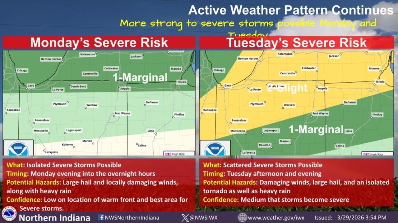
Monday Severe Risk — Level 1 Marginal:
- Gary and La Porte — northwest Indiana, within the Marginal risk zone
- South Bend and Plymouth — north-central Indiana directly in the risk corridor
- Fort Wayne — northeast Indiana within the Marginal severe risk area
- Logansport, Monticello and Kokomo — central Indiana communities in the risk zone
- Warsaw and Defiance — included in the Monday outlook footprint
- Benton Harbor and Coldwater, Michigan — northern fringe of the Marginal risk zone
Tuesday Severe Risk — Level 2 Slight and Level 1 Marginal:
- Gary, La Porte and South Bend — upgraded to Level 2 Slight risk Tuesday — higher severe weather coverage
- Fort Wayne and Angola — within the Slight risk zone Tuesday
- Logansport, Kokomo and Lafayette — Level 1 Marginal risk Tuesday
- Kalamazoo and Benton Harbor, Michigan — northern extent of Tuesday’s risk area
- Toledo, Ohio — eastern fringe of the Tuesday severe weather zone
Primary Threats Monday Night and Tuesday
NWS Northern Indiana has outlined distinct hazard profiles for each day:
Monday Evening Into Overnight:
- Isolated severe storms possible beginning Monday evening and continuing into the overnight hours
- Large hail — primary severe weather threat Monday night
- Locally damaging winds alongside heavy rain
- Confidence: Low on the exact location of the warm front and best area for severe storms — timing and placement still uncertain
Tuesday Afternoon and Evening:
- Scattered severe storms possible — broader coverage than Monday’s isolated threat
- Damaging winds — primary threat Tuesday
- Large hail — continuing threat into the second round
- Isolated tornado — cannot be ruled out Tuesday as confidence in storm severity increases
- Heavy rain — flooding concerns with multiple rounds of rainfall
- Confidence: Medium that storms become severe Tuesday — higher certainty than Monday’s outlook
Why Tuesday Carries a Higher Severe Weather Risk for Northern Indiana
The upgrade from Level 1 Marginal on Monday to Level 2 Slight across much of Northern Indiana on Tuesday reflects a more favorable atmospheric setup for organized severe weather. Tuesday’s storm environment is expected to feature better wind shear, stronger instability and a more defined forcing mechanism — the combination that allows thunderstorms to become more organized and sustain severe characteristics longer.
The addition of an isolated tornado threat on Tuesday — absent from Monday’s hazard list — is particularly noteworthy for communities across the South Bend, Gary and Fort Wayne corridors. While tornado potential remains in the isolated category, Northern Indiana residents should have a severe weather safety plan in place before Tuesday afternoon.
Monday’s lower confidence is tied to uncertainty in the position of the warm front — a key ingredient that determines exactly where the best severe storm environment sets up. If the warm front pushes further north than currently expected, severe storm risk could expand northward into additional communities.
Multi-Day Pattern: Active Weather Continues
The NWS Northern Indiana forecast makes clear this is not a one-and-done severe weather event. The active weather pattern driving back-to-back storm chances across Northern Indiana is expected to persist through at least the middle of next week. Residents across South Bend, Fort Wayne, Gary and Lafayette should be prepared for the possibility of additional storm rounds beyond Tuesday as the pattern remains energized.
What to Watch Next
Key details to monitor as this two-day severe weather event develops:
- Warm front position Monday — determines exactly where Monday night’s severe storm risk is highest across Northern Indiana
- Tuesday storm initiation timing — whether severe storms fire during the afternoon or wait until evening across South Bend and Fort Wayne
- Tornado watch or warning issuance Tuesday — particularly for the Slight risk zone covering Gary, South Bend and Fort Wayne
- Rainfall totals — multiple rounds of heavy rain could lead to localized flooding across Northern Indiana
- NWS Northern Indiana updates at weather.gov/iwx as confidence increases through Monday
Residents across South Bend, Fort Wayne, Gary, La Porte, Plymouth, Logansport, Kokomo and Lafayette should ensure weather alerts are enabled on mobile devices, review severe weather safety plans and monitor NWS Northern Indiana forecast updates closely through Monday and Tuesday.
WaldronNews.com will continue tracking this active severe weather pattern across Northern Indiana and provide updated storm timing, hazard details and watch or warning information as Monday and Tuesday’s events develop.