
Southern California Enjoys Warm Spring Weekend Before Pacific Storm Brings Gusty Winds and Showers Midweek as Arizona and New Mexico Eye Above Normal Monsoon Season
LOS ANGELES, CALIFORNIA — Southern California is basking in a pleasant spring weekend with above-normal temperatures running 10 to 15 degrees above average and dry conditions across the region. The warm stretch extends into Monday before a Pacific storm system moves inland to the north late Tuesday into Wednesday, bringing gusty west winds up to 30 mph and light showers to parts of the region. Meanwhile, an early monsoon-type moisture surge from Sonora, Mexico is already firing active convection across Southern Arizona — and long-range models are signaling a potentially wetter than normal monsoon season ahead for Arizona and New Mexico.
Areas in the Weather Zone
The weekend through midweek forecast affects a broad corridor of the Southwest United States:
Southern California — Above Normal Warmth:
- Los Angeles metro — highs 10 to 15 degrees above average this weekend and Monday
- San Diego and Orange County — warm and dry through the weekend
- Inland Empire — peak warmth Monday before cooling begins Tuesday
- Colorado River Valley — isolated storm possible from early monsoon moisture today
Midweek Storm — Tuesday Into Wednesday:
- Northern Southern California — closest to the Pacific storm track moving inland to the north
- Los Angeles and surrounding areas — mainly marine layer light rain and drizzle possible
- Mountains above 8,000 feet — snow level rising, minimal accumulation expected
- Rainfall totals — generally staying under one-tenth of an inch across most of the region
Arizona and New Mexico — Monsoon Signal:
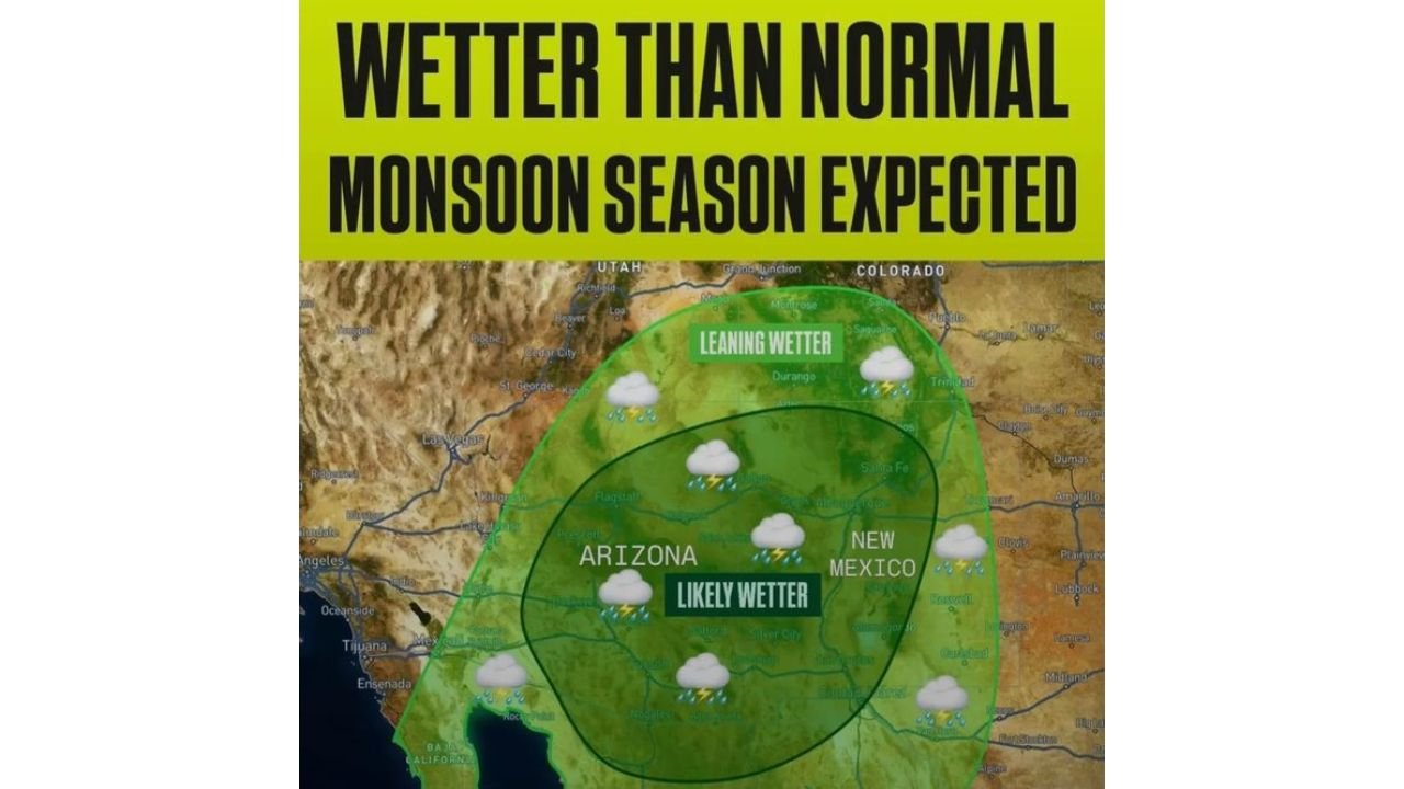
- Arizona — classified as “Likely Wetter” on long-range monsoon outlook maps
- New Mexico — also in the “Likely Wetter” zone for the upcoming monsoon season
- Southern Arizona — active convection firing today from large MCS turned MCV over Sonora
- Colorado River Valley — isolated storm possible as this moisture pushes north
- Utah and Colorado — in the “Leaning Wetter” zone on extended monsoon outlooks
Primary Weather Impacts — Weekend Through Next Weekend
The forecast covers several distinct weather phases across the Southwest:
- This weekend — 10 to 15 degrees above normal across Southern California, dry and pleasant
- Monday — highs remain well above average, warmest day of the stretch before the cool-down
- Tuesday into Wednesday — Pacific storm moves inland to the north, gusty west winds to 30 mph, a few showers and marine layer drizzle possible across Southern California
- Rainfall totals — under one-tenth of an inch for most; bulk of moisture stays north of the area
- Snow level — above 8,000 feet during the midweek storm
- Late Wednesday onward — temperatures begin creeping back up, dry weather returns through next weekend
- Today in Southern Arizona — active convection from early monsoon moisture surge, strongest storms east of SoCal, isolated storm near the Colorado River Valley possible
Why the Early Monsoon Signal Matters for Arizona and New Mexico
The early taste of monsoon-type moisture arriving from Sonora, Mexico this weekend is more than just a current weather story — it is a potentially significant signal for what the summer of 2026 could hold for Arizona and New Mexico. A large Mesoscale Convective System (MCS) that turned into a Mesoscale Convective Vortex (MCV) over Sonora last night has pushed a decent surge of moisture northward into Southern Arizona, with convection firing up again today.
Long-range models are already hinting that this early activity is consistent with a pattern that historically favors an above-normal monsoon season across the Desert Southwest. The monsoon outlook map shows Arizona in the “Likely Wetter” category and surrounding states including New Mexico, Utah and Colorado in the “Leaning Wetter” zone — potentially excellent news for drought-stressed communities across the region heading into summer.
Forecasters describe this as a potentially good sign for an active summer monsoon season — with above-normal rainfall for the Desert Southwest already hinted at by long-range modeling guidance.
Multi-Day Pattern: Warming Returns After Midweek Dip
After the Tuesday into Wednesday Pacific storm brushes through with limited rainfall and gusty winds, Southern California is expected to warm back up heading through next weekend with dry weather returning for the foreseeable future. The brief cool-down from the Pacific system will moderate the above-normal temperatures without delivering meaningful drought relief across the region.
The bigger weather story for the Southwest shifts to late spring and summer — where the early monsoon moisture signals and long-range model guidance point toward a potentially active and wetter than normal 2026 monsoon season for Arizona and New Mexico.
What to Watch Next
Key details to monitor across the Southwest in the days ahead:
- Tuesday wind timing — when exactly gusty west winds to 30 mph arrive across Southern California
- Rainfall totals Wednesday — whether any areas exceed the one-tenth of an inch threshold
- Colorado River Valley storm activity — whether today’s isolated storm threat materializes from Arizona monsoon moisture
- Southern Arizona convection — ongoing MCV moisture activity east of Southern California today
- Long-range monsoon model trends — whether the wetter than normal signal for Arizona and New Mexico strengthens or weakens through April
- Temperature rebound — how quickly Southern California warms back to above-normal levels after the midweek system
Residents across Los Angeles, San Diego, the Inland Empire and the Colorado River Valley should enjoy the warm weekend while preparing for the brief but windy midweek storm. Residents across Tucson, Phoenix, Flagstaff and Albuquerque should watch closely as early monsoon signals continue to develop this spring.
WaldronNews.com will continue tracking the midweek Pacific storm, ongoing Arizona monsoon moisture activity and the developing long-range monsoon outlook for Arizona and New Mexico as the pattern evolves heading into April.