
Illinois, Missouri, Arkansas and Louisiana Face Increasing Severe Weather Risk Thursday April 2 as Deep Moisture and Strong Wind Shear Target the Midwest Down to the Gulf Coast
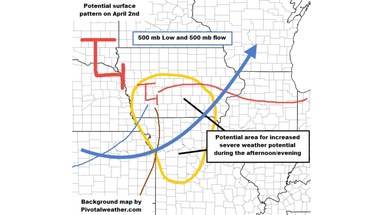
SPRINGFIELD, ILLINOIS — Severe weather forecasters are keeping a close eye on Thursday, April 2 as a potentially significant storm day for a wide corridor stretching from the Midwest all the way down to the Gulf Coast. A powerful atmospheric setup — featuring deep moisture, favorable thermodynamic conditions for thunderstorms and seasonably strong wind shear — may be coming together across Illinois, Missouri, Arkansas, Mississippi and Louisiana during the afternoon and evening hours. The potential surface weather pattern for April 2 shows a classic severe weather setup, with a 500 mb low-pressure system and associated upper-level flow driving energy into a focused zone where the risk for organized and dangerous thunderstorms increases significantly.
This is still a 3 to 4 day forecast, and models are not yet in full agreement — but Thursday is standing out as the most concerning day of the week for severe weather potential from the Midwest to the Gulf Coast.
States and Areas in the Potential Severe Weather Zone
Based on the April 2 potential surface pattern, the increased severe weather risk area is focused across:
- Illinois — particularly central and southern Illinois where the upper-level flow intersects with surface boundaries
- Missouri — the warm front and dry line interaction zone creates elevated storm potential across the state
- Arkansas — squarely within the yellow-highlighted potential severe area for Thursday afternoon and evening
- Mississippi — southern extent of the severe weather corridor down toward the Gulf
- Louisiana — Gulf Coast communities within the severe weather potential zone Thursday evening
- Kansas and Oklahoma — western fringe of the setup where surface boundaries are intersecting
- Indiana and Kentucky — eastern edge of the potential severe weather corridor
The yellow oval on the April 2 surface pattern map marks the area of most concentrated severe weather potential — centered across the Missouri, Arkansas and Illinois tri-state area with the threat extending both northward toward Iowa and southward toward the Gulf Coast.
Primary Threats Thursday April 2
The combination of ingredients coming together for Thursday creates the potential for:
- Deep moisture surging northward from the Gulf of Mexico — one of the key fuels for severe thunderstorm development
- Favorable thermodynamic profiles — the atmosphere is expected to be loaded with instability, giving storms the energy to become intense
- Seasonably strong wind shear — the change in wind speed and direction with height that allows thunderstorms to rotate and become organized
- 500 mb low-pressure system tracking northeastward — providing the large-scale forcing to trigger and sustain thunderstorm development
- Multiple surface boundaries — a warm front, dry line and cold front all converging in the same area, which is a classic recipe for severe weather across the Midwest and South
- Afternoon and evening timing — peak storm activity expected during the most dangerous hours when heat and instability are maximized
Why Thursday Stands Out From the Rest of the Week
Out of all the storm chances expected this week, Thursday, April 2 is the day forecasters are watching most closely. The reason comes down to how all the ingredients line up at the same time and place. Deep moisture from the Gulf Coast, combined with strong upper-level winds from the southwest and a focused surface low, creates the kind of environment where supercell thunderstorms — the most dangerous type — can develop and persist.
One veteran forecaster put it simply: “If I were living in the area, I would be watching Thursday closely.”
The catch right now is model uncertainty. At the 3 to 4 day range, weather models are still disagreeing on exactly how far east or west the surface features end up — meaning the exact location of the highest risk could shift between now and Thursday. Communities across Missouri, Illinois, Arkansas and down through Louisiana should all be treating Thursday as a potential severe weather day regardless of where the models eventually agree the best setup lands.
What the Surface Pattern Map Shows for April 2
The potential surface pattern for April 2 shows the key features that severe weather meteorologists watch:
A 500 mb low — a powerful pool of cold air high in the atmosphere — is positioned over the central Plains, with associated upper-level flow sweeping northeastward into the Great Lakes region. At the surface, a warm front is draped across the northern portion of the risk area — separating the coolest air to the north from the unstable warm and moist air to the south. A dry line and cold front are intersecting across the western portion of the risk zone, creating a focal point where thunderstorms are most likely to initiate during the afternoon.
The yellow oval on the map marks where all of these features converge — and that convergence zone is centered squarely across Missouri, Illinois and Arkansas.
Multi-Day Pattern: Active Week Continues Through the Weekend
Thursday’s severe weather potential does not exist in isolation — it is part of an active and unsettled weather pattern that is expected to affect the Midwest, South and Gulf Coast through much of the first week of April. Multiple rounds of storms are possible both before and after April 2, meaning residents across Illinois, Missouri, Arkansas, Mississippi and Louisiana should be in a weather-aware mindset throughout the entire week — not just on Thursday.
The broader pattern is being driven by the same large-scale atmospheric setup that is bringing below-normal temperatures to the central and eastern United States — and with that cold air clashing against Gulf moisture, the ingredients for repeated severe weather outbreaks are very much in place.
What to Watch Next
As Thursday, April 2 approaches, the key things to monitor include:
- Model agreement on the position of the surface low and frontal boundaries — the next 24 to 48 hours of model runs will sharpen the picture significantly
- SPC severe weather outlooks — watch for the Storm Prediction Center to begin issuing Day 3 and Day 2 outlooks targeting Missouri, Illinois, Arkansas and Louisiana
- Tornado watch or warning potential — if the setup comes together as currently suggested, tornado watches across the Midwest and Mid-South are possible Thursday afternoon
- Timing of storm initiation — whether storms fire during the early afternoon or hold off until evening hours across Missouri and Arkansas
- Gulf Coast timing — whether Thursday evening storms reach Louisiana and Mississippi or remain confined to the northern portion of the risk zone
Residents across Illinois, Missouri, Arkansas, Mississippi and Louisiana should make sure weather alerts are enabled on their mobile devices, review severe weather safety plans, and check back for updates from WaldronNews.com as Thursday’s setup comes into sharper focus over the next 48 hours.
WaldronNews.com will continue tracking this developing severe weather threat and provide state-specific updates for Illinois, Missouri, Arkansas, Mississippi and Louisiana as model guidance improves heading into Thursday.