
Texas and Oklahoma Under Slight Risk of Severe Storms Wednesday April 1 as Large Hail, Damaging Winds and Tornadoes Target Oklahoma City, Dallas and Tulsa Late Afternoon Into Evening
OKLAHOMA CITY, OKLAHOMA — The Storm Prediction Center has issued a Level 2 Slight Risk of severe weather for Wednesday, April 1, 2026 across portions of Texas and Oklahoma, with Oklahoma City, Tulsa and Dallas sitting in the highest-risk zone for a potentially dangerous late afternoon and evening storm event. Large hail, significant damaging winds and a couple of tornadoes are all possible as the storm system develops. Before a likely line of thunderstorms forms, semi-discrete supercells may fire ahead of the line — and those supercells are capable of producing significant hail that could cause serious damage to vehicles, roofs and outdoor property across the Oklahoma City and Dallas corridors.
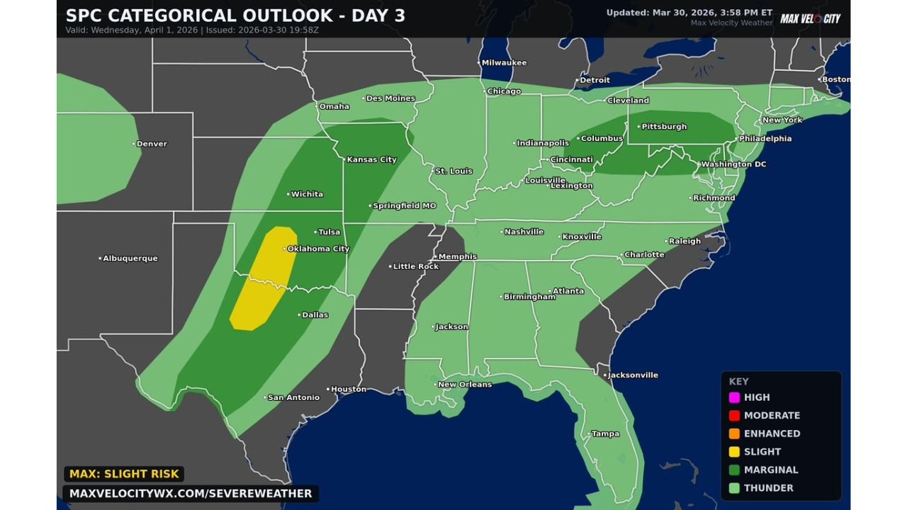
The SPC Day 3 Categorical Outlook, updated March 30, 2026 at 3:58 PM ET, is valid for Wednesday, April 1, 2026 and places the Slight Risk zone across a corridor from north-central Texas through central Oklahoma — with a broader Marginal Risk extending across much of the central and eastern United States from the Plains through the Ohio Valley and Southeast.
States and Cities in the Severe Weather Zone
Level 2 Slight Risk — Wednesday April 1:
- Oklahoma: Oklahoma City, Tulsa — highest risk communities Wednesday
- Texas: Dallas, and north-central Texas communities below Oklahoma City
Level 1 Marginal Risk — broader surrounding area:
- Kansas: Wichita corridor on the northern fringe
- Missouri: Springfield, St. Louis
- Arkansas: Little Rock
- Tennessee: Nashville and Memphis
- Kentucky and Indiana: Louisville, Lexington, Indianapolis
- Ohio: Columbus, Cincinnati, Cleveland
- Pennsylvania and Mid-Atlantic: Pittsburgh, Philadelphia, Washington D.C., Richmond
- Carolinas: Charlotte, Raleigh on the eastern fringe
Primary Threats Wednesday for Texas and Oklahoma
The SPC and Max Velocity Weather are highlighting the following specific hazards for Wednesday April 1:
- Large hail — the leading threat ahead of the main storm line, particularly from semi-discrete supercells firing before the squall line organizes
- Significant damaging winds — once the line of thunderstorms develops, widespread wind damage is possible across Oklahoma and north Texas
- A couple of tornadoes — the tornado threat is real but conditional, tied to whether supercells can stay discrete long enough to develop rotation before being absorbed into the line
- Timing — late afternoon and evening — this is not a morning event. The primary window for severe weather across Oklahoma City, Tulsa and Dallas is during the late afternoon and evening hours Wednesday
The most important detail for residents of Oklahoma City and Tulsa is the supercell phase before the line arrives. Semi-discrete supercells ahead of a squall line are often the most dangerous storms of an event — capable of producing large hail, tornadoes and damaging winds all at once before the more organized but less tornado-prone line takes over.
What Residents of Oklahoma City, Tulsa and Dallas Need to Know
If you live in Oklahoma City or Tulsa, Oklahoma — you are in the heart of the Slight Risk zone for Wednesday. Your afternoon and evening plans should include a weather awareness check. Know where you will shelter if a tornado warning is issued for your area. The late afternoon timing means this event could coincide with the evening commute — which makes it especially important to know your surroundings and have a plan if severe weather develops while you are away from home.
If you live in Dallas, Texas — you are on the southern edge of the Slight Risk zone. Large hail from supercells before the main line arrives is the most likely impact for the Dallas area. A brief tornado cannot be ruled out but is less likely for Dallas than for communities further north in central Oklahoma.
If you live anywhere in the broader Marginal Risk zone — from Kansas and Missouri through Tennessee, Kentucky, Ohio and the Mid-Atlantic — scattered thunderstorm chances exist Wednesday but the threat level is lower. Isolated damaging wind gusts and small hail are possible but a major severe weather outbreak is not expected outside the Texas and Oklahoma Slight Risk corridor.
Multi-Day Pattern: This Is Not a One-Day Event
Wednesday’s severe weather risk for Texas and Oklahoma is one chapter in a multi-day active weather pattern sweeping across the central and eastern United States this week. Tuesday brought severe weather risks to the Great Lakes, Wednesday targets Oklahoma and Texas, and the Thursday April 2 setup — which forecasters have been watching closely — still carries significant potential for organized severe weather from the Midwest down to the Gulf Coast. Residents across the region should remain weather-aware throughout the entire week.
What to Watch Next
- Wednesday afternoon supercell development across central Oklahoma — the first storms of the day will be the most tornado-capable
- Storm Prediction Center watches — watch for possible severe thunderstorm or tornado watches to be issued for Oklahoma City, Tulsa and Dallas Wednesday afternoon
- Line of thunderstorms timing — how quickly the squall line organizes will determine how long the supercell phase lasts and how significant the tornado threat becomes
- Hail reports from central Oklahoma during the mid-afternoon hours as supercells develop
- Thursday setup update — after Wednesday’s event, attention immediately shifts to the April 2 severe weather potential for the broader Midwest and South
Residents across Oklahoma City, Tulsa and Dallas should have weather alerts enabled on mobile devices, know their shelter plans and be ready to act quickly Wednesday afternoon and evening.
WaldronNews.com will continue tracking Wednesday’s severe weather threat across Texas and Oklahoma and provide live updates on watches, warnings and storm reports as the event develops.