
Oklahoma City, Wichita Falls and Abilene Face Significant Severe Weather Wednesday April 1 as Supercells Along Oklahoma and Texas Dryline Quickly Become Dangerous Squall Line With Embedded Tornadoes
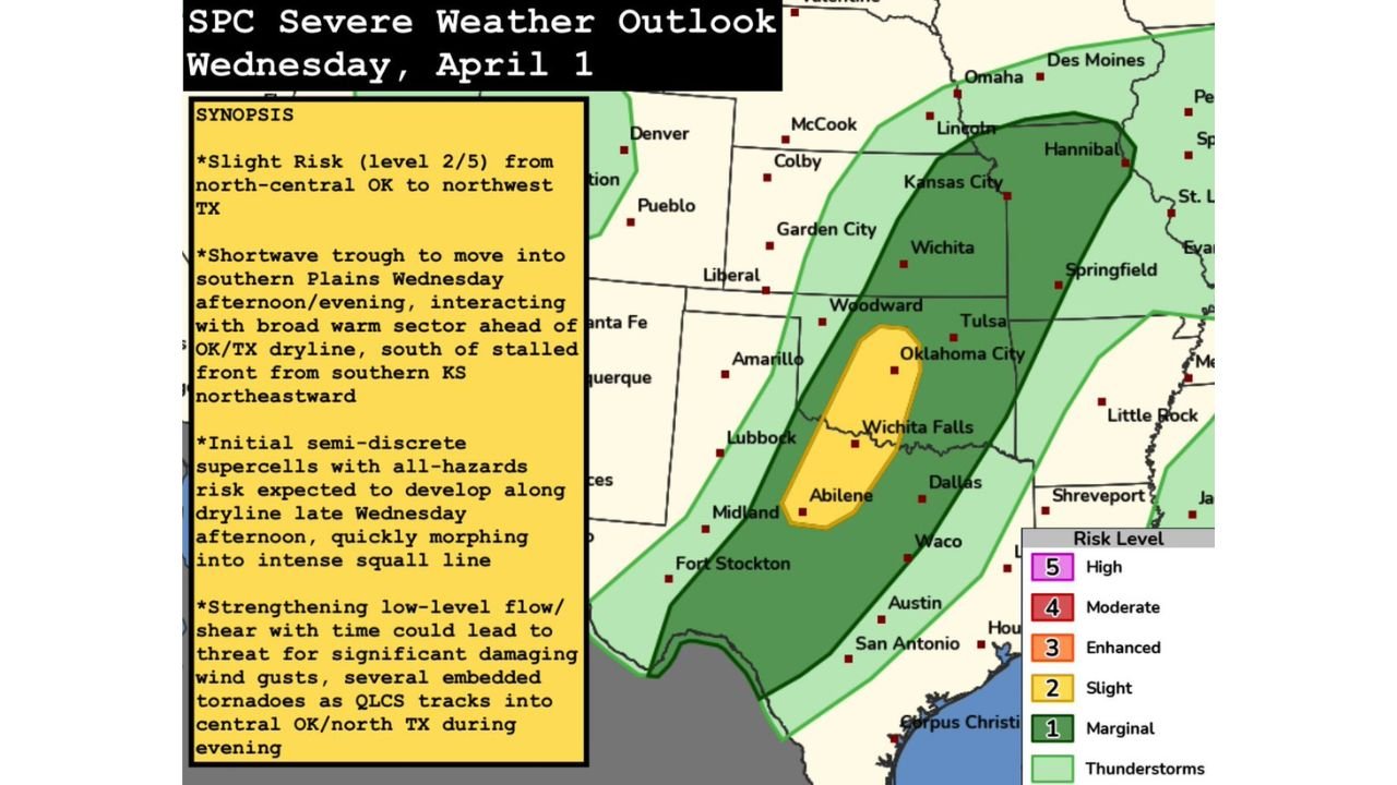
OKLAHOMA CITY, OKLAHOMA — A significant severe weather event is taking shape for Wednesday, April 1, 2026 across the Southern Plains, with the Storm Prediction Center issuing a Level 2 Slight Risk covering a corridor from north-central Oklahoma through northwest Texas — including communities near Oklahoma City, Wichita Falls, Abilene, Woodward and Amarillo. The threat begins Wednesday afternoon with semi-discrete supercells developing along the dryline in the western Oklahoma and northwest Texas vicinity before quickly morphing into an intense quasi-linear convective system (QLCS) — a fast-moving squall line — that will push eastward through Wednesday night into early Thursday morning carrying a long-duration threat for significant damaging wind gusts and several embedded tornadoes.
This is not a brief pop-up storm event. The combination of a strengthening low-level jet, broad warm sector ahead of the line and a shortwave trough moving into the Southern Plains Wednesday afternoon creates a setup that could produce dangerous storms from late afternoon all the way through the overnight hours.
Cities and States in the Severe Weather Zone
Level 2 Slight Risk — Wednesday April 1:
- Oklahoma: Oklahoma City, Woodward, Wichita Falls corridor — highest risk along the dryline initiation zone
- Texas: Northwest Texas including Wichita Falls, Abilene, Amarillo and the Lubbock area
Level 1 Marginal Risk — surrounding area:
- Kansas: Wichita, Garden City, Liberal, Colby
- Oklahoma: Tulsa and eastern Oklahoma communities
- Texas: Dallas, Waco, Austin, San Antonio — eastern and southern fringe
- Missouri: Springfield, Kansas City corridor
- Arkansas: Little Rock on the far eastern edge
How This Storm Event Will Unfold Wednesday
The SPC synopsis lays out a clear and concerning storm evolution for Wednesday April 1:
Step 1 — Late Wednesday afternoon: A shortwave trough drops into the Southern Plains and interacts with the Oklahoma and Texas dryline — the boundary where dry desert air from the west collides with warm moist Gulf air from the east. Along this dryline, semi-discrete supercells will fire. These initial supercells carry an all-hazards risk — meaning large hail, damaging winds and tornadoes are all possible from each individual storm cell during the early phase.
Step 2 — Wednesday evening: The individual supercells quickly merge and organize into a QLCS — a quasi-linear convective system — which is essentially a fast-moving line of intense thunderstorms. As the line tracks eastward into central Oklahoma and north Texas, the low-level jet strengthens, feeding more energy and wind shear into the storm system.
Step 3 — Wednesday night into early Thursday morning: The squall line pushes through central Oklahoma and north Texas carrying a long-duration threat for significant damaging wind gusts along the entire line. Embedded tornadoes within the QLCS are also possible — these are often the most dangerous type because they can be difficult to detect on radar and give residents very little warning time.
Primary Threats for Oklahoma and Texas Wednesday
- Significant damaging wind gusts — the primary and most widespread threat as the squall line moves through central Oklahoma and north Texas overnight
- Several embedded tornadoes — possible within the QLCS as it tracks eastward Wednesday night — these tornadoes may have very short warning lead times
- Large hail — during the initial supercell phase along the dryline before the line organizes, large hail is likely across western Oklahoma and northwest Texas
- Long-duration event — unlike a brief afternoon storm, this threat extends from late afternoon Wednesday all the way through early Thursday morning — an overnight severe weather threat is particularly dangerous because many residents will be asleep
Why the Overnight Threat Makes This Event Especially Dangerous
The most concerning aspect of Wednesday’s setup for residents of Oklahoma City, Woodward and Abilene is not the afternoon supercell phase — it is the overnight QLCS threat. When a squall line pushes through a region in the middle of the night, most residents are asleep and not actively monitoring weather alerts. Embedded tornadoes within a QLCS can form and touch down with very little lead time — sometimes only 5 to 10 minutes of warning — making it critical that residents have a weather alert device — such as a NOAA weather radio or phone alert — that will wake them up if a warning is issued for their area.
If you live in central Oklahoma or north Texas, do not assume that because storms begin during the afternoon that the overnight hours are safe. The squall line and its embedded tornado threat may be at its most dangerous while you are sleeping.
What to Watch Next
- Wednesday afternoon dryline initiation — whether supercells fire on schedule along the western Oklahoma and northwest Texas dryline between 3 and 6 PM local time
- SPC watch issuance — watch for tornado watches or severe thunderstorm watches to be issued for Oklahoma and Texas Wednesday afternoon and evening
- QLCS organization — how quickly the line consolidates and how intense the low-level shear becomes as it pushes eastward overnight
- Overnight tornado warnings — have a weather alert app or NOAA radio set and ready to wake you if warnings are issued Wednesday night
- Thursday morning all-clear — when the squall line exits to the east and the threat ends for Oklahoma City and central Oklahoma
Residents across Oklahoma City, Woodward, Wichita Falls, Abilene and Amarillo need to take Wednesday April 1 seriously from start to finish — and make sure their overnight severe weather plans are in place before going to sleep Wednesday night.
WaldronNews.com will continue tracking Wednesday’s severe weather threat across Oklahoma and Texas and provide live updates on watches, warnings and storm reports through the overnight hours.