
Salt Lake City, Ogden and Park City Utah Face Up to 1 Inch of Heavy Rain Tuesday Night as Atmospheric River Drives Cold Front Through the Wasatch Front
SALT LAKE CITY, UTAH — Heavy rain is on the way for communities along Utah’s Wasatch Front as moisture from an atmospheric river is already streaming into the Southwest today, bringing increasing clouds across Utah with a few high-based showers possible in western portions of the state this afternoon. The main event arrives Tuesday evening into the overnight hours when a strengthening trough and cold front move through — delivering the heaviest precipitation of the system to Salt Lake City, Ogden, Park City, Tooele and surrounding communities. Some areas along the Wasatch Front could see 0.5 to 1 inch of rain by Wednesday morning — a meaningful soaking for a region that welcomes every drop of moisture it can get heading into spring.
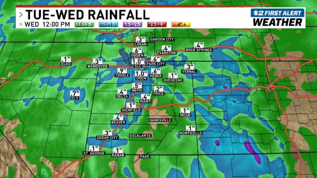
City by City Rainfall Forecast — Tuesday into Wednesday
The CBS 2 First Alert Weather rainfall forecast, valid through Wednesday 12:00 PM, shows the following totals across Utah:
Highest totals — Wasatch Front and surrounding mountains:
- Salt Lake City — 1.0 inch
- Park City — 1.0 inch — tied with SLC for the highest totals in the forecast
- Tooele — 0.9 inch — just west of the Salt Lake Valley, picking up nearly a full inch
- Ogden — 0.6 inch — northern Wasatch Front community seeing solid totals
- Orem — 1.0 inch — Utah Valley matching Salt Lake for the top of the range
- Heber — 0.6 inch — mountain valley community east of Park City
- Evanston (Wyoming border) — 0.6 inch
Moderate totals — central and southern Utah:
- Logan — 0.3 inch
- Wendover — 0.3 inch
- Delta — 0.4 inch
- Nephi — 0.5 inch
- Manti — 0.4 inch
- Richfield — 0.1 inch
- Price — 0.2 inch
- Duchesne — 0.1 inch
- Vernal — 0.3 inch
Lighter totals — southern and eastern Utah:
- Cedar City — 0.3 inch
- St. George — 0.1 inch
- Kanab — 0.1 inch
- Moab — 0.1 inch
- Monticello — 0.1 inch
- Beaver — 0.4 inch
Nevada:
- Elko — 0.1 inch
- Ely — 0.7 inch — notably higher totals for a Nevada community
Wyoming:
- Rock Springs — 0.4 inch
- Garden City area — 0.3 inch
What an Atmospheric River Means for Utah
An atmospheric river is essentially a narrow corridor of concentrated moisture in the atmosphere — often described as a river of water vapor in the sky — that can transport enormous amounts of precipitation-producing moisture over thousands of miles. When an atmospheric river makes landfall and encounters mountains like the Wasatch Range, the moisture is forced upward and condenses rapidly, producing heavy rainfall at lower elevations and significant snow at higher mountain elevations.
The atmospheric river feeding Tuesday night’s storm is already making its presence known across Utah today with increasing clouds and scattered high-based showers. But the main punch arrives Tuesday evening when the cold front pushes through — that is when the heaviest rain rates will occur across Salt Lake City, Ogden, Park City and the surrounding Wasatch Front communities.
Why Tuesday Night Is the Time to Watch
The heaviest precipitation from this system will not fall during the afternoon or morning — it is a Tuesday evening into overnight event driven by the cold front moving through. For residents of Salt Lake City and the Wasatch Front, this timing means:
- Evening commute could be impacted by the onset of heavy rain Tuesday — roads becoming wet and slick as the front arrives
- Overnight rainfall will accumulate while most residents are asleep — waking up Wednesday morning to potentially flooded low-lying areas, ponded roadways and wet roads
- Gardeners and homeowners who want to take advantage of the incoming moisture should apply fertilizer or soil amendments before the storm hits Tuesday — once the heavy rain arrives, applications will be washed away before they can absorb
What This Storm Means for the Wasatch Mountains
While the forecast map focuses on valley and lower elevation rain totals, the Wasatch Mountains above Salt Lake City, Park City and Ogden will see even heavier precipitation — falling as snow at higher elevations as the cold front pushes temperatures down through Tuesday night. Ski resorts and mountain communities above approximately 7,000 to 8,000 feet elevation may see fresh snowfall accumulation overnight Tuesday into Wednesday morning.
What to Watch Next
- Tuesday evening storm arrival timing — whether the cold front reaches Salt Lake City before or after the evening commute
- Rainfall rates — whether any areas exceed the 1 inch forecast, particularly in the Park City and Orem corridors where the highest totals are expected
- Mountain snow levels — how low snow falls across the Wasatch Range overnight Tuesday
- Wednesday morning road conditions — wet and potentially slick roads across the Salt Lake Valley and Wasatch Front following overnight rainfall
- Additional systems — whether the broader active pattern brings more moisture to Utah later in the week
Residents across Salt Lake City, Ogden, Park City, Tooele and Orem should prepare for heavy rain arriving Tuesday evening and persisting through much of Tuesday night, with conditions improving by Wednesday afternoon.
WaldronNews.com will continue tracking this atmospheric river event and provide updated rainfall totals for the Utah Wasatch Front as the storm system approaches Tuesday.