
Texas, Oklahoma and Kansas Upgraded to Level 3 Enhanced Risk Wednesday April 1 as SPC Issues Damaging Winds, Large Hail and Tornado Threat From Wichita Through Oklahoma City to Dallas
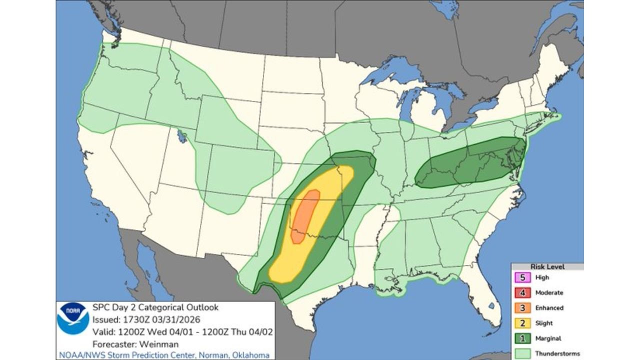
OKLAHOMA CITY, OKLAHOMA — The Storm Prediction Center has upgraded Wednesday’s severe weather risk to Level 3 Enhanced across parts of Texas, Oklahoma and Kansas — a significant escalation that signals a more organized and dangerous severe weather event than initially forecast. The SPC Day 2 Categorical Outlook, issued March 31, 2026 at 1730Z and valid from Wednesday April 1 through Thursday April 2, now shows an orange Enhanced Risk zone covering a corridor from north Texas through central Oklahoma and into Kansas — with the highest wind, hail and tornado probabilities concentrated in a tightly focused bullseye stretching from the Dallas area northward through Oklahoma City toward Wichita.
Damaging winds and large hail are the primary threats, but a few tornadoes will be possible across the Enhanced Risk zone — and the SPC has specifically noted that higher tornado probabilities may be issued in later outlooks as confidence increases heading into Wednesday.
Risk Levels Across Texas, Oklahoma and Kansas
Level 3 Enhanced Risk:
- The core orange zone covering portions of north-central Texas, central Oklahoma and southern Kansas — the highest categorical risk for Wednesday
- Communities in or near this zone include Oklahoma City, Tulsa, Wichita Falls, Abilene and the corridor between them
Level 2 Slight Risk:
- Surrounding the Enhanced zone, covering a broader area of Texas, Oklahoma, Kansas, Missouri and Arkansas
- Wichita, Kansas City, Joplin, Springfield, Little Rock and surrounding communities
Level 1 Marginal Risk:
- The widest zone, extending across much of the central United States from the High Plains through the Ohio Valley
Secondary Enhanced and Slight Risk — East Coast:
- A separate risk area exists across Virginia, North Carolina and the Mid-Atlantic — indicating a secondary severe weather corridor on the East Coast Wednesday
Three Separate SPC Outlooks — Wind, Hail and Tornado Breakdown
The SPC has issued three individual probability maps for Wednesday, each telling a specific part of the story:
Wind Outlook — Highest Threat: The wind probability map shows the most intense probability bullseye of all three hazards — with a red zone indicating 45% or greater probability of damaging winds within 25 miles across central Oklahoma. A surrounding yellow zone of 30 to 45% probability extends through north Texas and southern Kansas. Significant damaging wind gusts — capable of downing trees, snapping power lines and causing structural damage — are the most certain outcome of Wednesday’s storm event across Oklahoma City and the surrounding corridor.
Hail Outlook — Large Hail Concentrated in Oklahoma: The hail probability map shows a similar pattern to the wind map — a red 45% or greater probability zone across central Oklahoma surrounded by yellow 30 to 45% probability across north Texas and southern Kansas. Large hail — potentially golf ball size or larger — is expected from supercells that develop before the main squall line organizes Wednesday afternoon. The semi-discrete supercell phase is when the largest hail is most likely across Oklahoma.
Tornado Outlook — 10 to 15% Probability With Hatching: The tornado probability map shows a 10% probability zone covering a large portion of the Texas to Kansas corridor, with a hatched area overlaid — indicating the possibility of significant tornadoes (EF2 or stronger) across central Oklahoma and portions of north Texas. The 10% probability may seem modest compared to the wind and hail values, but it represents a genuine and serious tornado threat across a densely populated region. The hatching means the SPC believes strong tornadoes are possible — not just brief touchdowns.
Primary Threats Wednesday for Oklahoma and Texas
- Damaging winds — the most likely and most widespread severe weather impact, with 30 to 45% probability of wind events across Oklahoma City, Tulsa and Wichita Falls
- Large hail — significant hail from supercells during the afternoon, before storms organize into a line. Golf ball size or larger possible in the core of the Enhanced zone
- Tornadoes — a few tornadoes possible, with strong tornadoes not ruled out across central Oklahoma and north Texas. Higher tornado probabilities may be added in later SPC updates Wednesday morning
- Storm evolution — the event likely begins with semi-discrete supercells Wednesday afternoon that produce large hail and tornado potential, then evolves into a squall line with damaging wind gusts Wednesday night
What This Enhancement Means for Oklahoma City and Wichita
When the SPC upgrades a risk from Slight to Enhanced, it means forecasters have gained confidence that the storm setup will be more organized, more widespread and more capable of producing multiple simultaneous severe weather reports across a concentrated area. For Oklahoma City — which sits in the heart of the Enhanced Risk zone — Wednesday is not a day to take lightly.
Residents across Oklahoma City, Edmond, Norman, Stillwater, Enid and the broader central Oklahoma metro should have shelter plans finalized Wednesday morning, not Wednesday afternoon. The storm window will not give much preparation time once it opens — and the combination of large hail during the supercell phase and damaging winds during the squall line phase means the severe weather threat spans much of the afternoon and evening.
For Wichita, Kansas — on the northern fringe of the Enhanced zone and in the Slight Risk zone — large hail and damaging winds are both possible Wednesday evening as the storm system tracks northward.
What to Watch Next
- SPC morning update Wednesday — watch for possible tornado probability upgrades from the current 10% to higher values as confidence increases
- Supercell initiation timing across north Texas and western Oklahoma Wednesday afternoon — the first storms will be the most tornado-capable
- Tornado watch issuance for Oklahoma and north Texas — expected during the Wednesday afternoon hours
- Squall line organization — how quickly individual supercells merge into a line will determine how long the tornado window lasts
- Oklahoma City evening timing — when exactly the squall line and its damaging wind threat arrives in the metro
- East Coast secondary risk — the separate severe weather corridor across Virginia and the Carolinas Wednesday also bears watching
Residents across Oklahoma City, Tulsa, Wichita Falls, Abilene, Wichita and all communities in the Level 3 Enhanced Risk zone should treat Wednesday April 1 as a serious severe weather day from start to finish — with shelter plans ready, weather alerts active and full attention on the forecast through the afternoon and evening hours.
WaldronNews.com will continue tracking Wednesday’s severe weather threat across Texas, Oklahoma and Kansas and provide live updates on watches, warnings, tornado reports and storm timing as the event unfolds.