
Western Oklahoma, North Texas and South-Central Kansas Upgraded to Level 3 Enhanced Risk Wednesday as Supercells With 2 Inch Hail Fire Along Dryline Then Push Damaging Winds and Tornadoes East Across I-35 Overnight
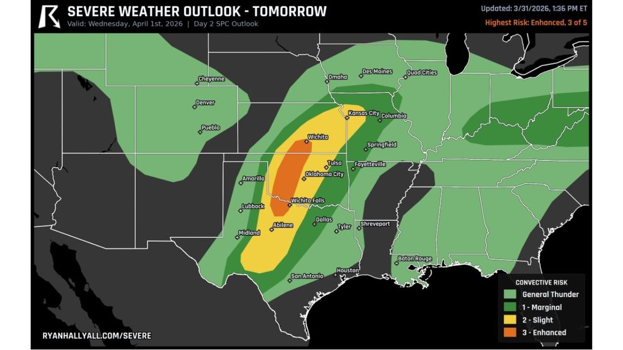
OKLAHOMA CITY, OKLAHOMA — Wednesday just got more dangerous. The SPC Day 2 Severe Weather Outlook has been upgraded to a Level 3 Enhanced Risk across western Oklahoma, north Texas and south-central Kansas — with supercells expected to fire along the dryline by late afternoon and then grow into a damaging wind and tornado threat as the storm system pushes east across the I-35 corridor overnight. The Ryan Hall Y’All Severe Weather Outlook, updated March 31, 2026 at 1:36 PM ET, shows the orange Enhanced zone centered directly over Oklahoma City, Tulsa, Wichita and Wichita Falls — and the storm evolution Wednesday is going to follow a two-phase script that every resident in the region needs to understand before Wednesday afternoon arrives.
Phase one is large hail from supercells. Phase two is damaging winds and tornadoes overnight along I-35. Both phases are dangerous.
The Storm Corridor — Who Is in the Highest Risk Zone
Level 3 Enhanced Risk — core danger zone:
- Oklahoma: Oklahoma City, Tulsa, Enid, Stillwater, Lawton — the heart of the Enhanced zone
- Kansas: Wichita and south-central Kansas communities
- Texas: Wichita Falls, Abilene — north and north-central Texas
Level 2 Slight Risk:
- Oklahoma: Eastern Oklahoma including Fayetteville area
- Kansas: Kansas City, Columbia corridor
- Missouri: Springfield, Kansas City
- Texas: Dallas, Tyler, Lubbock on the fringe
- Arkansas: Fayetteville corridor
Level 1 Marginal Risk:
- Iowa: Des Moines, Quad Cities
- Missouri: Full state coverage
- Texas: San Antonio through Houston corridor
- Louisiana: Shreveport, Baton Rouge
How Wednesday’s Storms Will Unfold — Two Dangerous Phases
Phase 1 — Late Afternoon: Dryline Supercells
By late afternoon Wednesday, supercells are expected to fire along the Oklahoma and Texas dryline — the boundary between dry desert air from the west and warm moist Gulf air pushing northward. These initial supercells are the most tornado-capable storms of the event and are where the 2-plus inch hail threat is concentrated.
Hail of 2 inches or larger — roughly the size of a silver dollar — can crack windshields, dent vehicles, damage roofing and injure anyone caught outside without cover. During the supercell phase, anyone in western Oklahoma, north Texas and south-central Kansas should be indoors with vehicles garaged or covered if possible.
Phase 2 — Overnight: Damaging Winds and Tornadoes Push East Across I-35
As the evening progresses, the individual supercells will merge into a damaging squall line that pushes eastward — crossing the I-35 corridor through Oklahoma City and into Tulsa and eastern Oklahoma during the overnight hours. This is when the damaging wind threat becomes most widespread and when embedded tornadoes within the line become the primary concern.
The I-35 corridor — running from Laredo, Texas northward through San Antonio, Austin, Waco, Dallas, Oklahoma City and Wichita — is the highway that defines the eastern edge of the most intense storm activity overnight Wednesday. Communities along and west of I-35 face the strongest and most prolonged severe weather threat. Communities east of I-35 — including Tulsa and eastern Oklahoma — face the risk as the line pushes through overnight.
Why the Overnight Phase Is the Most Dangerous for Oklahoma City
When a severe squall line crosses Oklahoma City in the overnight hours, most residents are asleep. The combination of fast storm motion, embedded tornadoes with short warning times and limited public awareness during sleeping hours creates conditions where the overnight phase of Wednesday’s storm can cause more casualties than the more dramatic-looking afternoon supercell phase.
For Oklahoma City residents: Do not go to sleep Wednesday night without a plan. Know your shelter location. Have a NOAA weather radio or weather alert app set to wake you if warnings are issued. The worst of the storm system may arrive between midnight and 4 AM for the metro area.
Primary Threats Wednesday for Western Oklahoma, North Texas and South-Central Kansas
- 2-plus inch hail — from dryline supercells firing late afternoon across western Oklahoma, north Texas and south-central Kansas. This is the first and most certain hazard of the day
- Damaging winds — widespread along the squall line as it pushes east across I-35 overnight — capable of snapping trees, downing power lines and causing structural damage
- Tornadoes — possible both during the afternoon supercell phase and as embedded tornadoes within the overnight squall line. Strong tornadoes cannot be ruled out during the supercell phase across western Oklahoma and north Texas
- Widespread power outages — the combination of large hail, damaging winds and a large geographic footprint makes widespread power disruptions likely across Oklahoma and north Texas Wednesday night
What to Watch Next
- Dryline supercell initiation time — whether storms fire before 4 PM or later in the afternoon across western Oklahoma and north Texas
- SPC tornado watch issuance — expected for Oklahoma and Texas Wednesday afternoon ahead of supercell development
- Supercell-to-squall line transition timing — how quickly individual storms merge into the squall line determines how long the large hail and isolated tornado window lasts
- I-35 crossing time for Oklahoma City — critical for residents knowing when to expect the overnight wind and tornado threat
- Morning updates Wednesday — the SPC may issue additional upgrades or increase tornado probabilities in the Day 1 outlook released Wednesday morning
Residents across Oklahoma City, Tulsa, Wichita, Wichita Falls and Abilene must treat Wednesday April 1 as a full-day and full-night severe weather event — with large hail in the afternoon and damaging winds with tornado potential crossing I-35 overnight. Prepare now and stay alert through Thursday morning.
WaldronNews.com will continue tracking Wednesday’s severe weather threat across western Oklahoma, north Texas and south-central Kansas and provide live updates on watches, warnings and storm reports through the overnight hours.