
Illinois, Eastern Iowa and Northern Indiana Face 15 Percent Tornado Probability Thursday as Storm Chasers Deploy Toward Chicago, Rockford, Davenport and the Broader Midwest Corridor
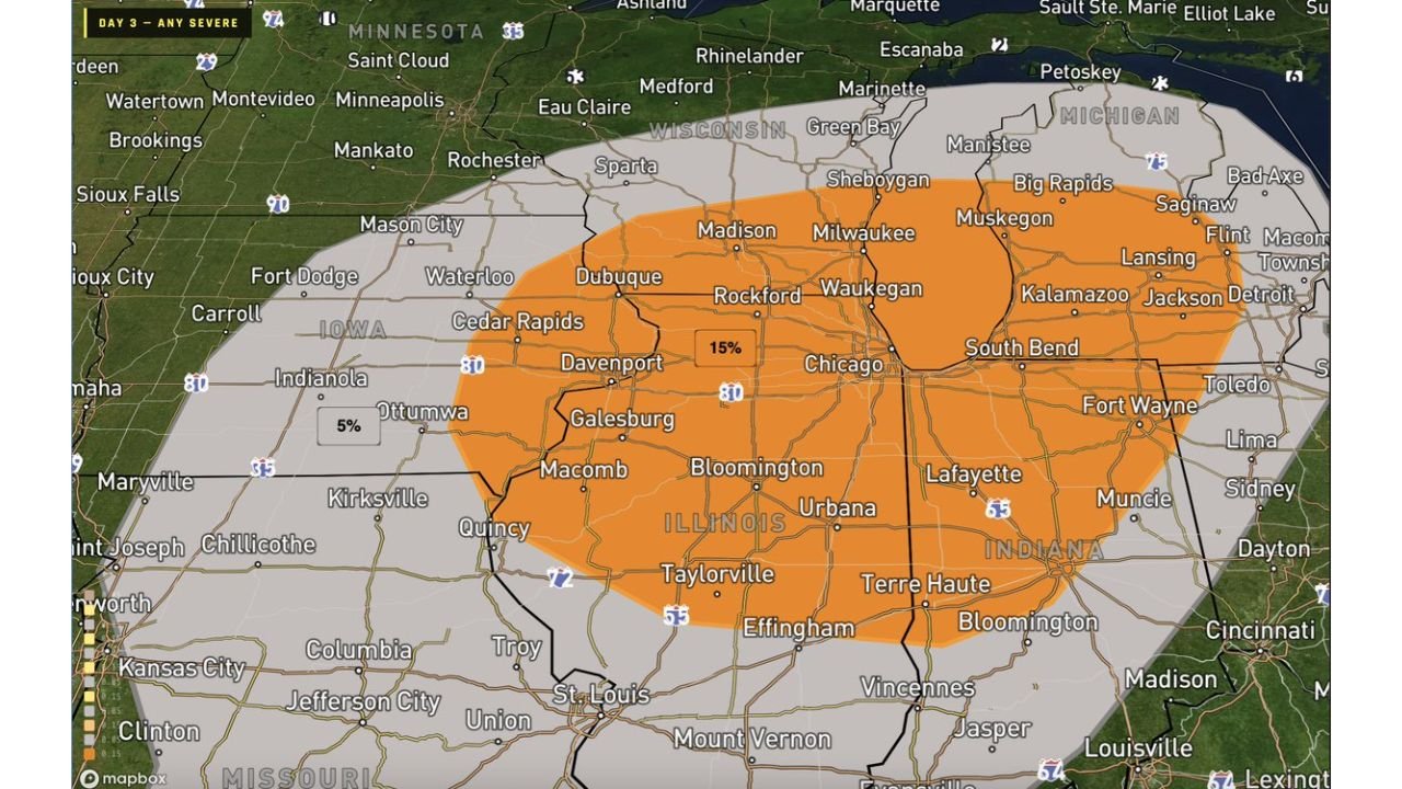
CHICAGO, ILLINOIS — Thursday April 2 is shaping up to be a significant severe weather day across Illinois, eastern Iowa and northern Indiana, with a 15% tornado probability centered over the Chicago, Rockford, Waukegan, Davenport and Kalamazoo corridor — a zone that includes some of the most densely populated communities in the Midwest. The SPC Day 3 any-severe outlook shows the highest probabilities concentrated in an orange oval stretching from eastern Iowa through all of northern and central Illinois into northwestern Indiana and southwestern Michigan — and professional storm chasing teams are already considering pre-season deployments into eastern Iowa and northern Illinois ahead of Thursday’s setup.
The RISE-26 pre-season storm chasing deployment being considered for Thursday — with equipment and staff potentially moving toward eastern Iowa and northern Illinois — is itself a significant signal. Professional chasing teams do not commit resources to a deployment unless the potential for significant tornadoes and severe weather justifies the effort.
Cities in the Highest Risk Zone Thursday
15% Tornado Probability — core risk area:
- Illinois: Chicago, Rockford, Waukegan, Bloomington, Urbana, Champaign, Galesburg, Macomb, Effingham, Taylorville
- Iowa: Davenport, Cedar Rapids, Dubuque, Waterloo, Fort Dodge, Mason City
- Indiana: South Bend, Lafayette, Terre Haute, Vincennes
- Michigan: Kalamazoo, Muskegon, South Bend corridor
5% Tornado Probability — broader surrounding area:
- Iowa: Ottumwa, Indianola, Carroll
- Missouri: St. Louis, Jefferson City, Columbia
- Indiana: Fort Wayne, Muncie, Bloomington
General Severe Risk — widest zone:
- Wisconsin: Milwaukee, Madison, Sheboygan
- Michigan: Grand Rapids, Lansing, Flint, Saginaw, Detroit
- Indiana: Toledo fringe, Lima, Dayton corridor
What Tornadoes, Wind and Hail Threat Means for Chicago and the Suburbs
The 15% tornado probability centered over Chicago and northern Illinois on a Day 3 outlook is a meaningful number that demands attention from residents across the metro area. A 15% probability means that within any 25-mile radius of a point in the highlighted zone, there is roughly a 1 in 7 chance of a tornado occurring — and that probability is concentrated precisely over the Chicago metropolitan area and its surrounding communities.
For context — most of the memorable tornado days that have affected Chicagoland in recent decades involved similar or lower probabilities in Day 3 outlooks. The SPC does not place 15% values over densely populated regions unless the atmospheric setup genuinely supports tornado development.
The combination of tornadoes, strong wind and hail all being on the table for Thursday means this is a full-hazard severe weather day for northern Illinois and the Chicago area — not just a wind event or just a hail event. The most dangerous storms Thursday could produce all three hazards within the same storm system.
Why Storm Chasers Are Deploying to Eastern Iowa and Northern Illinois
When professional storm chasing operations consider moving equipment and staff ahead of an event — as the RISE-26 deployment is contemplating for eastern Iowa and northern Illinois Thursday — it signals that the atmospheric setup has the ingredients for photogenic, organized and potentially significant severe weather. Storm chasers specifically position for events where discrete supercell thunderstorms are possible — storms capable of producing large tornadoes, significant hail and dramatic visual displays.
The consideration of dual simultaneous soundings and a 6 to 10 unit data probe deployment if the forecast trends more volatile indicates that forecasters are seriously evaluating this as a scientifically significant event. Atmospheric soundings provide real-time data on wind shear, instability and moisture — critical for understanding exactly how dangerous individual storms will become as they develop Thursday afternoon.
The Thursday Timing Picture
Thursday’s severe weather threat for Illinois, Iowa and Indiana is expected to develop during the afternoon and evening hours — following the classic pattern of daytime heating fueling storm initiation before the cold front pushes through and organizes the activity. The exact timing of storm initiation across eastern Iowa and northern Illinois will depend on when surface temperatures peak and how aggressively the frontal boundary triggers thunderstorm development.
The Chicago metro area should be monitoring forecasts closely through Thursday morning — the afternoon commute and evening hours are the most likely window for the heaviest storm activity to affect the region.
What to Watch Next
- Thursday morning SPC Day 1 outlook — watch for possible upgrades beyond 15% tornado probability as model confidence increases and the setup becomes a same-day forecast
- Storm initiation time across eastern Iowa and Davenport — the first Thursday afternoon supercells will set the tone for the event
- Tornado watch issuance for northern Illinois and Chicago — expected during the Thursday afternoon hours
- RISE-26 deployment decision — whether the chasing team commits to eastern Iowa and northern Illinois, which would confirm high confidence in an organized severe weather event
- Dual sounding deployment — if conditions trend volatile enough to trigger the full 6 to 10 unit probe deployment, that is a signal of very high scientific interest in Thursday’s setup
- Chicago metro timing — when exactly the highest-risk storm activity reaches the I-90 and I-294 corridors Thursday afternoon and evening
Residents across Chicago, Rockford, Waukegan, Davenport, Cedar Rapids, South Bend and Kalamazoo should treat Thursday April 2 as a potentially significant severe weather day — with tornado, wind and hail all possible — and have shelter plans ready before Thursday afternoon.
WaldronNews.com will continue tracking Thursday’s developing severe weather threat across Illinois, Iowa and Indiana and provide updates on watches, warnings and storm chaser deployment decisions as the event approaches.