
Oklahoma, Kansas and Missouri Face Up to 30 Percent Tornado Probability Wednesday April 1 as Nadocast Model Shows Very Active Severe Weather Day With EF2 Tornado Potential
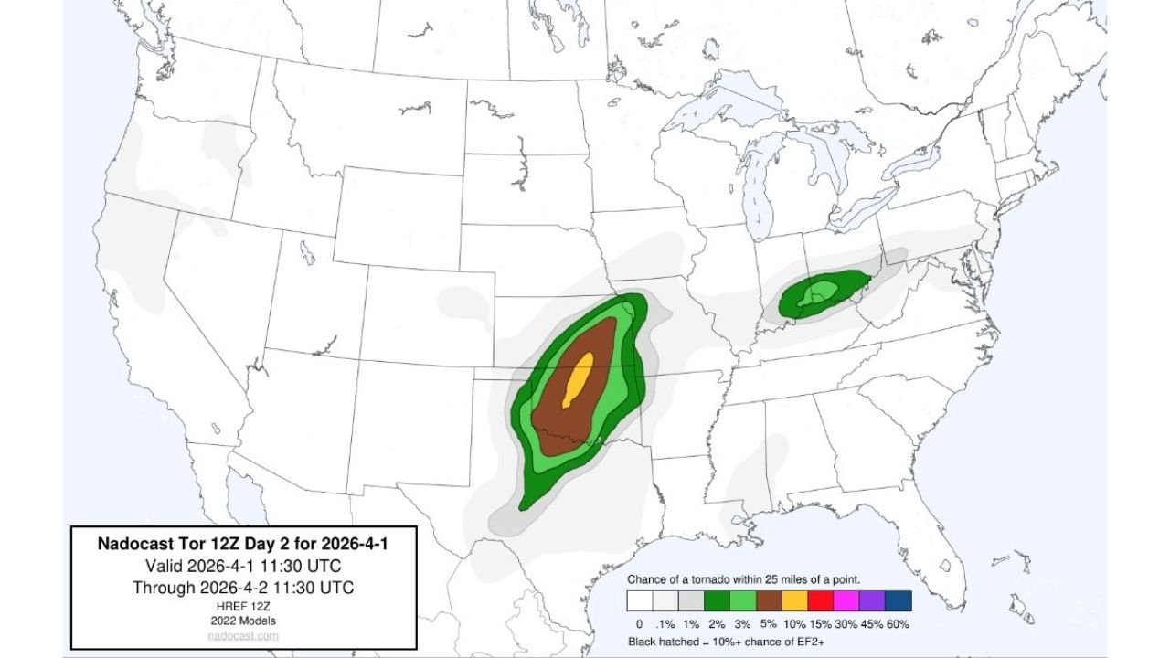
OKLAHOMA CITY, OKLAHOMA — The Nadocast tornado probability model — one of the most respected independent tornado forecasting tools used by meteorologists and storm chasers — is painting a deeply concerning picture for Wednesday, April 1, 2026 across Oklahoma, Kansas and Missouri. The Nadocast Day 2 forecast, valid from April 1 through April 2 at 11:30 UTC, shows a concentrated bullseye of 30% or greater tornado probability centered over the Oklahoma and Kansas border corridor — with the highest probabilities, shown in yellow, reaching into the 30 to 45% range in the most focused part of the risk zone. The black hatching overlaid on the core of the risk area signals a 10% or greater chance of EF2 or stronger tornadoes — the kind of tornadoes that destroy well-built homes and cause life-threatening damage.
A secondary tornado risk area is also visible on the Nadocast map across Virginia and the Mid-Atlantic — confirming that Wednesday’s severe weather threat is not limited to the Southern Plains.
What the Nadocast Probability Zones Show
The Nadocast tornado probability map uses color coding to show the chance of a tornado occurring within 25 miles of any given point. Here is what Wednesday’s map shows for each zone:
Yellow zone — 30% or greater tornado probability:
- The tightest and most dangerous zone, centered over central Oklahoma and the Kansas border
- Communities in or near this zone face the highest individual tornado risk on the map
- This zone also carries the black hatching for 10% EF2 or stronger tornado potential
Orange zone — 15% to 30% tornado probability:
- Surrounding the yellow core, covering a broad area of western Oklahoma, south-central Kansas and northern Texas
- Oklahoma City, Wichita and Wichita Falls are within or very close to this zone
Brown and dark green zones — 5% to 15% probability:
- Extending the risk through eastern Oklahoma, Missouri, Arkansas and the surrounding corridor
- Tulsa, Joplin, Springfield and Kansas City within this range
Light green zones — 1% to 3% probability:
- The widest area, covering much of the central United States from the Plains through the Ohio Valley
Secondary risk — Virginia and the Mid-Atlantic:
- A separate green oval visible over Virginia and surrounding states confirms a secondary tornado risk corridor on the East Coast Wednesday — independent of the main Southern Plains event
What EF2 or Stronger Means for Oklahoma and Kansas
The black hatching on the Nadocast map is not placed casually. It indicates that the model sees a meaningful probability of significant, long-track tornadoes — not just brief touchdowns. An EF2 tornado produces winds of 111 to 135 mph. At that intensity a tornado will:
- Destroy well-constructed frame homes — roofs torn off, walls collapsed
- Overturn and throw vehicles — including SUVs and pickup trucks
- Uproot large trees entirely from the ground
- Destroy mobile homes completely even if tied down
An EF3 or stronger — also possible in the hatched zone — causes catastrophic damage even to brick and concrete structures.
For residents of central Oklahoma, south-central Kansas and the immediate surrounding area — the black hatching on this map is the most serious single piece of information you need to act on today to prepare for Wednesday.
The Nadocast Is Showing One of the Most Focused Bullseyes of the Season
What makes Wednesday’s Nadocast map particularly striking is the concentration and intensity of the probability gradient. The transition from the light green outer zone all the way to the yellow 30%-plus inner zone happens over a relatively small geographic area — meaning the tornado risk is not spread thinly across a huge region but instead concentrated tightly over a specific corridor.
This kind of tight, well-defined probability bullseye from the Nadocast — using HREF 12Z 2022 Models — is what professional meteorologists and storm chasers look for when evaluating whether a severe weather day will produce isolated tornadoes versus an organized outbreak with significant tornado potential. Wednesday is showing the latter.
Who Needs to Take This Most Seriously
The residents who need to treat Wednesday with the greatest urgency are those living in communities within or near the yellow and orange zones on the Nadocast map — which translates to communities across central and western Oklahoma, south-central Kansas and north-central Texas. Specifically:
Anyone living in a mobile home or manufactured housing in these areas should identify a sturdy shelter location — a friend’s home, a community shelter or a nearby permanent structure — and have a plan to get there before storms develop Wednesday afternoon. Mobile homes offer virtually no protection against EF2 or stronger tornadoes.
Anyone living in a single-story frame home in the hatched zone should know their interior shelter options — a basement if available, or an interior room on the lowest floor away from windows if no basement exists.
Wednesday is not a day to shelter in place and hope for the best if you live in the hatched zone. It is a day to have a plan, execute it early and stay aware throughout the afternoon and evening.
What to Watch Next
- Wednesday morning SPC Day 1 tornado outlook — watch for the formal SPC tornado probability map to be issued. If it aligns with the Nadocast bullseye, the 30%+ zone may receive an official 10% or 15% significant tornado hatching from the SPC
- Tornado watch issuance — expected for central Oklahoma and south-central Kansas Wednesday afternoon ahead of dryline supercell development
- First storm initiation along the dryline — the first supercells of the day are likely to be the most tornado-capable before the squall line organization begins
- Nadocast Day 1 update Wednesday morning — the Day 1 forecast will provide even sharper probability guidance as the event becomes a same-day forecast
- Virginia and Mid-Atlantic secondary risk — the separate tornado risk oval over Virginia also warrants monitoring for residents across that region Wednesday
Residents across central Oklahoma, south-central Kansas, Wichita, Oklahoma City, Wichita Falls and the immediate surrounding corridor must treat Wednesday as a high-end severe weather day with significant tornado potential and act accordingly before Wednesday afternoon.
WaldronNews.com will continue tracking Wednesday’s tornado threat across Oklahoma and Kansas and provide live updates on watches, warnings and tornado reports as the event develops.