
Oklahoma City, Dallas, Tulsa and Wichita Face High Risk of Severe Thunderstorms Wednesday Afternoon and Night as AccuWeather Warns of 85 mph Wind Gusts, Large Hail and Tornadoes
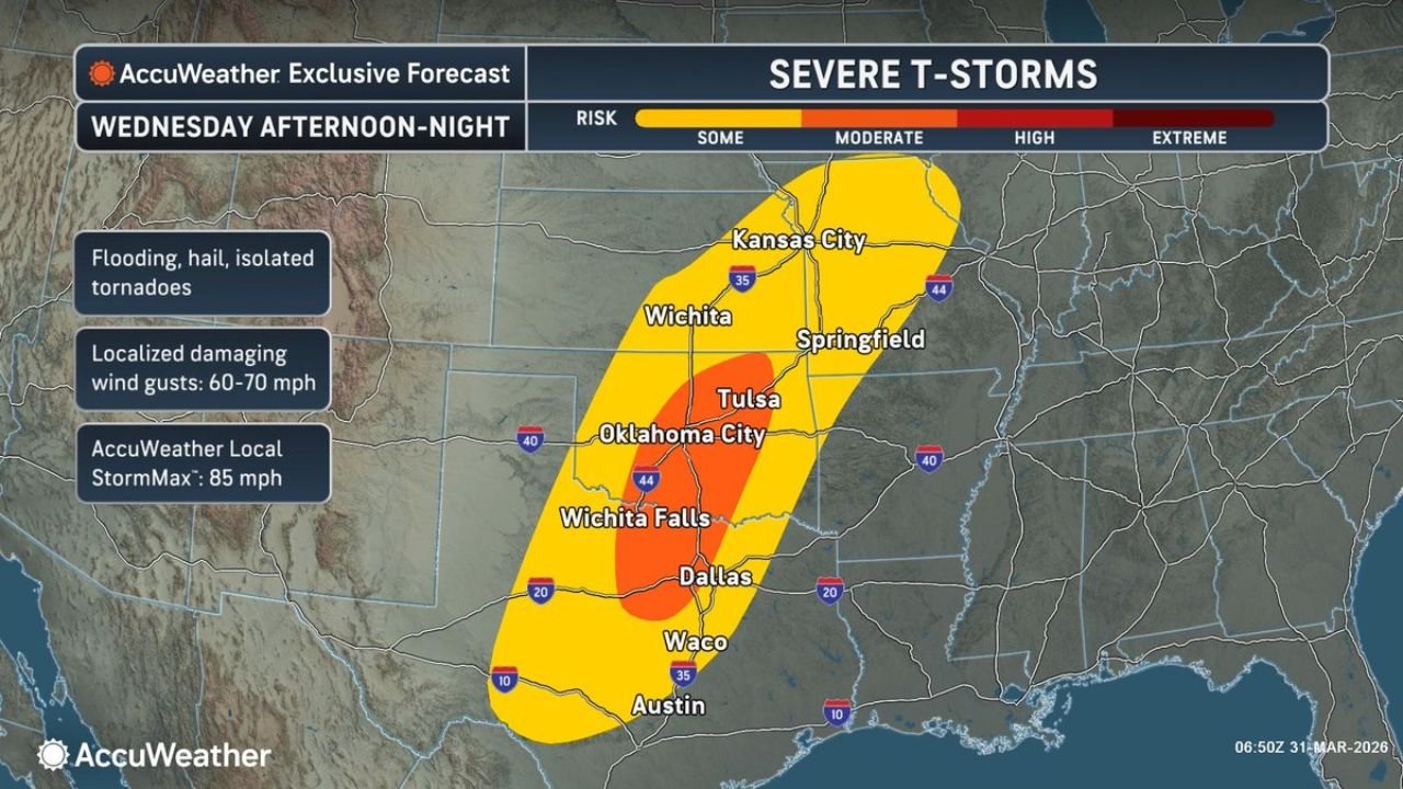
OKLAHOMA CITY, OKLAHOMA — AccuWeather is issuing some of its strongest severe weather language of the season for Wednesday afternoon and night, placing Oklahoma City, Dallas, Tulsa, Wichita and Wichita Falls in a High risk zone for severe thunderstorms — with an AccuWeather Local StormMax of 85 mph wind gusts possible in the most intense storm cells. The AccuWeather Exclusive Forecast for Wednesday afternoon through night, issued March 31, 2026 at 6:50 AM UTC, shows a High risk corridor in orange centered directly over the Oklahoma City, Tulsa, Wichita Falls and Dallas corridor, surrounded by a broader Moderate risk zone extending from Kansas City and Springfield south through Waco and Austin, Texas.
The combination of flooding rain, hail, isolated tornadoes and localized damaging wind gusts of 60 to 70 mph — with the AccuWeather StormMax reaching 85 mph — makes Wednesday one of the most dangerous severe weather days of the year across the Southern Plains.
Who Is in the Highest Risk Zone Wednesday
High Risk — orange zone on the AccuWeather map:
- Oklahoma: Oklahoma City, Tulsa, Stillwater, Enid, Lawton — the core of the most dangerous storm corridor
- Texas: Wichita Falls, Dallas — directly in the High risk zone
- Kansas: Wichita — northern extent of the High risk area
Moderate Risk — yellow zone:
- Kansas: Kansas City on the northern fringe
- Missouri: Springfield
- Texas: Waco, Austin — southern extent of the moderate zone
- Oklahoma: Eastern Oklahoma communities east of Tulsa
What AccuWeather Is Forecasting for Wednesday
The AccuWeather Exclusive Forecast breaks down the hazards for Wednesday afternoon and night as follows:
Flooding rain — heavy rainfall capable of causing flash flooding, particularly in low-lying areas and urban environments across Oklahoma City, Dallas and Tulsa. Streets and underpasses can flood quickly when storm cells stall or train over the same area.
Large hail — significant hail expected from supercells that develop before the main storm line organizes Wednesday afternoon. The semi-discrete supercell phase is when the largest hail is most likely across central Oklahoma and north Texas.
Isolated tornadoes — the tornado threat is real and explicitly included in AccuWeather’s hazard list for the High risk zone. While not the most likely outcome for every community in the corridor, Oklahoma City, Tulsa and Wichita Falls residents must treat the tornado possibility seriously.
Localized damaging wind gusts of 60 to 70 mph — the most widespread severe weather threat across the entire storm corridor. Wind gusts at this level will down trees, snap power lines and cause widespread property damage across communities from Wichita through Oklahoma City to Dallas.
AccuWeather Local StormMax of 85 mph — this is AccuWeather’s estimate of the maximum wind gust that could occur in the strongest individual storm cells. At 85 mph, winds are capable of causing structural damage to homes, flipping vehicles and creating conditions indistinguishable from a weak tornado in terms of property destruction.
Why 85 mph Wind Gusts Are So Dangerous
The AccuWeather StormMax of 85 mph is worth understanding in practical terms. Most people associate tornado damage with rotating funnels — but a straight-line wind gust of 85 mph from a downburst or bow echo within a severe thunderstorm can cause damage that looks nearly identical to a weak EF0 or EF1 tornado.
At 85 mph:
- Large trees are uprooted entirely from the ground
- Roofs are partially lifted from homes
- Vehicles are pushed off roads or overturned
- Power lines and utility poles snap — causing widespread and prolonged outages
- Debris becomes a serious projectile hazard for anyone outdoors
For residents of Oklahoma City, Dallas and Tulsa — 85 mph wind gusts arriving without adequate shelter or warning time can be life-threatening. This is not a storm to watch from a window or a porch.
The Storm Corridor From Kansas City to Austin
The AccuWeather map shows the severe storm threat stretching in a long north-to-south corridor running the length of I-35 — from Kansas City in the north all the way south through Oklahoma City and Dallas to Waco and Austin, Texas. This corridor aligns with the I-35 corridor that connects some of the most populated communities in the central United States.
For commuters and travelers on I-35 Wednesday evening — this highway runs directly through the heart of the High and Moderate risk zones. Do not be on I-35 in Oklahoma or north Texas during the peak storm window Wednesday evening if you have any alternative.
What to Watch Next
- Wednesday afternoon severe thunderstorm and tornado watch issuance for Oklahoma and north Texas — expected before the first storms fire
- Dallas storm timing — whether the High risk zone produces significant storms over Dallas and the DFW metro during the afternoon or evening hours
- Oklahoma City peak storm time — the highest risk window for the metro is expected during the late afternoon and evening as the storm system organizes
- AccuWeather updates throughout Wednesday — the StormMax values may be revised upward or downward as model guidance sharpens
- Wind damage reports from western Oklahoma and north Texas during the afternoon supercell phase before the main line arrives
Residents across Oklahoma City, Tulsa, Wichita, Wichita Falls and Dallas should be in their shelter locations before Wednesday afternoon storms develop — not after. Have weather alerts active, know your shelter plan and do not underestimate the threat that 85 mph wind gusts and isolated tornadoes pose to your community Wednesday evening.
WaldronNews.com will continue tracking Wednesday’s severe weather threat across Oklahoma and Texas and provide live updates on watches, warnings and wind damage reports as the event unfolds.