
Iowa and Missouri Face Level 3 Enhanced Risk of Severe Storms Friday April 3 as SPC Warns of Very Large Hail, Damaging Winds and Tornadoes From Des Moines and Davenport Through Kansas City and St. Louis
DES MOINES, IOWA — The Storm Prediction Center has issued its Key Messages for Friday, April 3, 2026 — and the message is clear and serious. Severe thunderstorms are expected Friday afternoon and evening across a corridor stretching from Iowa southward through the southern Plains, with the highest confidence for dangerous storms concentrated across northern Missouri and southern Iowa where a Level 3 Enhanced Risk — the third highest on a five-point scale — is already in place. Very large hail, severe damaging winds and tornadoes are all explicitly listed as possible hazards for Friday, making this the third consecutive day of significant severe weather potential across the central United States.
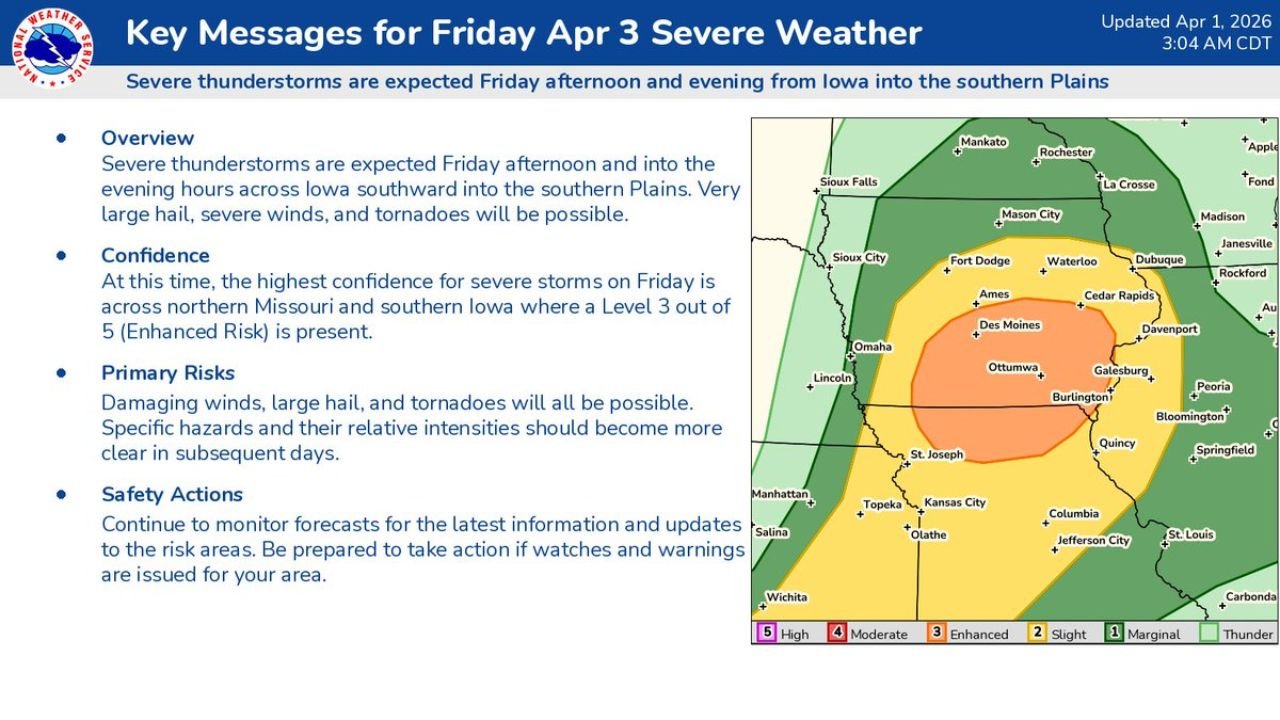
The SPC Key Messages graphic, updated April 1, 2026 at 3:04 AM CDT, places the orange Enhanced Risk zone directly over Des Moines, Ottumwa, Burlington, Davenport, Galesburg and the Kansas City corridor — communities that will be watching a potentially dangerous Friday afternoon develop.
States and Cities in Friday’s Severe Weather Zone
Level 3 Enhanced Risk — highest confidence zone:
- Iowa: Des Moines, Ottumwa, Burlington, Ames, Fort Dodge — southern and central Iowa in the core of the Enhanced zone
- Missouri: Kansas City, St. Joseph, Columbia, Jefferson City — northern Missouri directly in the highest-risk corridor
Level 2 Slight Risk:
- Iowa: Cedar Rapids, Dubuque, Waterloo, Davenport, Sioux City on the outer edges
- Nebraska: Lincoln and Omaha on the western fringe
- Kansas: Topeka, Wichita on the southern fringe
- Missouri: St. Louis, Springfield — southeastern Missouri
Level 1 Marginal Risk:
- Minnesota: Rochester, Mankato, La Crosse corridor
- Wisconsin: Janesville, Rockford area
- Illinois: Bloomington, Peoria, Springfield, Quincy
SPC Key Messages for Friday — Direct From the Forecast
The Storm Prediction Center Norman, Oklahoma laid out four specific key messages for Friday’s event:
Overview: Severe thunderstorms are expected Friday afternoon and into the evening hours across Iowa southward into the southern Plains. Very large hail, severe winds and tornadoes will all be possible across this corridor.
Confidence: The highest confidence for severe storms Friday is across northern Missouri and southern Iowa — exactly where the Level 3 Enhanced Risk is placed. This means the SPC has the most certainty about storm impacts in the Des Moines, Ottumwa and Kansas City areas compared to the broader surrounding region.
Primary Risks: Damaging winds, large hail and tornadoes are all on the table. The SPC notes that specific hazard details and relative intensities will become clearer in subsequent forecast updates as Friday gets closer.
Safety Actions: Monitor forecasts continuously for the latest information. Be prepared to take action immediately if watches and warnings are issued for your area. This is not passive monitoring language — the SPC is explicitly telling residents to be ready to act.
Why Friday Follows Wednesday and Thursday as the Third Dangerous Day
Friday April 3 completes what is shaping up to be a historic three-day severe weather stretch across the central United States:
- Wednesday April 1 — Enhanced Risk across western Oklahoma, north Texas and south-central Kansas with supercells, large hail, damaging winds and tornadoes
- Thursday April 2 — Elevated tornado threat across northern Illinois, Indiana and Michigan with the cold front pushing east
- Friday April 3 — Enhanced Risk shifts northward to southern Iowa and northern Missouri as the storm pattern continues its march eastward and a new storm system energizes the atmosphere
Each day targets a different geographic corridor — but together they represent a multi-day severe weather outbreak affecting a broad swath of the central United States from the Southern Plains through the Midwest and Great Lakes.
The fact that Friday already carries a Level 3 Enhanced Risk with more than two days of lead time is significant. The SPC does not place Enhanced Risk designations at the Day 3 range unless they have high confidence in a genuinely dangerous setup — and the confidence language in Friday’s key messages confirms exactly that for the Des Moines and Kansas City corridor.
What Very Large Hail Means for Iowa and Missouri
The SPC’s use of “very large hail” — rather than simply “large hail” — is a specific escalation in language that indicates hail of 2 inches or larger is expected in the strongest Friday storm cells. Hail of this size causes:
- Cracked and shattered vehicle windshields
- Significant dents to vehicle hoods, roofs and trunks
- Damaged roofing across homes and businesses
- Broken skylights and windows
- Injury to anyone caught outside without cover
For residents of Des Moines, Kansas City and the broader Enhanced Risk zone — moving vehicles to covered parking before Friday afternoon is one of the simplest and most effective preparations you can make.
What to Watch Next
- Friday morning SPC Day 1 outlook — the formal categorical and individual hazard probability maps will sharpen the picture significantly for Iowa and Missouri as Friday becomes a same-day forecast
- Tornado watch issuance for southern Iowa and northern Missouri — expected Friday afternoon as storms begin developing
- Storm initiation timing across Kansas and Nebraska — the first Friday afternoon supercells will track northeastward and determine how quickly the threat reaches Des Moines and Kansas City
- SPC outlook upgrades — whether the Enhanced zone expands or intensifies beyond current forecasts in Thursday evening and Friday morning updates
- Wednesday and Thursday storm impacts — how much Wednesday and Thursday’s events affect soil moisture and atmospheric conditions heading into Friday
Residents across Des Moines, Ames, Ottumwa, Burlington, Kansas City and St. Joseph should treat Friday April 3 as a serious severe weather day — monitor forecasts through Thursday evening and be ready to act immediately when watches and warnings are issued Friday afternoon.
WaldronNews.com will continue tracking Friday’s developing severe weather threat across Iowa and Missouri and provide updated hazard details as the SPC refines the forecast through Thursday.