
Oklahoma, Texas, Kansas, Illinois, Iowa and Wisconsin Placed Under Multi Day Severe Weather Alert With Tornado Risk Peaking Thursday
UNITED STATES — A significant multi-day severe weather outbreak is now unfolding across the Central United States and Midwest, with dangerous storms, tornado potential, and damaging winds expected from Wednesday through Friday. Authorities are urging residents across multiple states to stay alert as conditions are expected to escalate in waves.
Wednesday Targets Southern Plains and Ohio Valley With Tornado and Hail Threat
The first phase of this outbreak is impacting the Southern and Central Plains along with parts of the Ohio Valley, including:
- Oklahoma, Texas, Kansas
- Ohio, West Virginia, Kentucky
Storms in these regions are expected to bring:
- Extreme wind gusts exceeding 75 mph
- Very large hail greater than 2 inches in diameter
- A heightened tornado risk
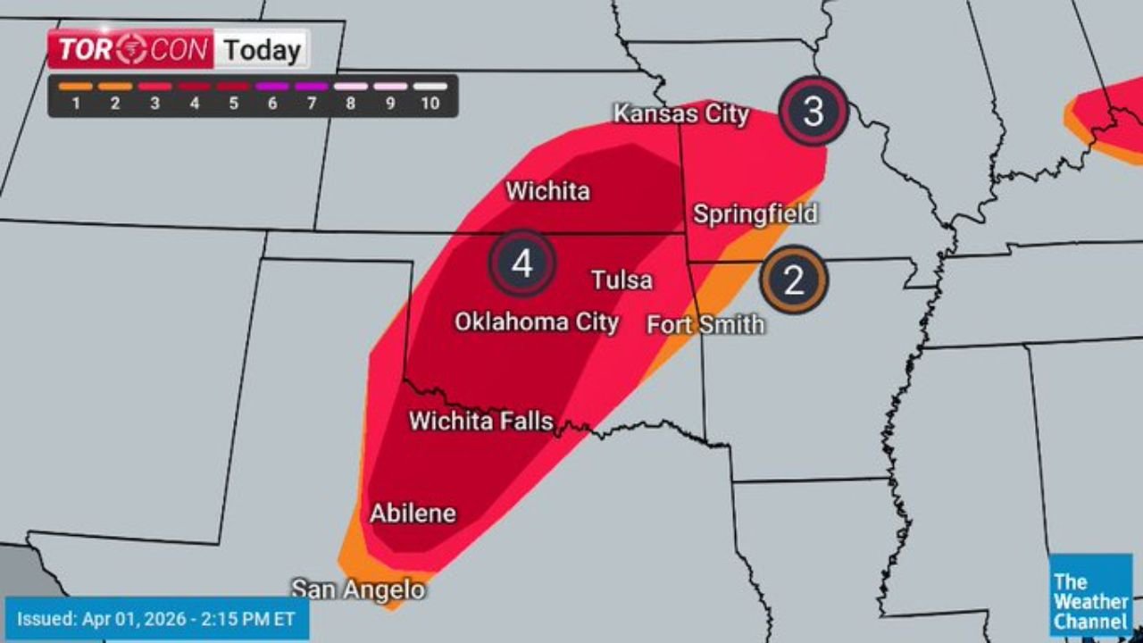
The most concerning zone today is centered around Oklahoma City, Tulsa, and Wichita Falls, where conditions have reached a TORCON level 4, indicating a strong likelihood of tornado development.
Thursday Shifts Dangerous Storm System Into Midwest and Great Lakes
By Thursday, the system moves northeast into the Midwest and Great Lakes, placing states like:
- Illinois
- Iowa
- Missouri
- Wisconsin
under a much more dangerous setup.
Forecast data shows:
- Severe storms likely from Des Moines to Chicago
- A high-end TORCON level 5 risk centered near Peoria and Davenport
- Increasing potential for multiple tornadoes during the afternoon and evening
This phase is particularly concerning because atmospheric conditions may support more organized and intense storm development, especially if daytime heating is not disrupted by earlier rainfall.
Friday Expands Threat Across a Broad Corridor From Great Lakes to Oklahoma
As the system continues eastward on Friday, the severe weather risk stretches across a wide corridor including:
- Great Lakes region
- Mid-Mississippi Valley
- Extending back into Oklahoma and surrounding Plains
The primary threats shift slightly but remain dangerous:
- Widespread damaging winds
- Large hail
- Continued risk of isolated severe storms
Cities including Des Moines, Kansas City, Springfield, Tulsa, and Fort Smith fall within zones marked as “likely” or “possible” for severe thunderstorms.
Why This Multi Day Event Is Concerning
This is not a single storm event but a prolonged and evolving system, meaning:
- Multiple rounds of storms could impact the same areas
- Conditions can rapidly intensify between morning and evening hours
- Tornado risk may shift locations each day, making tracking essential
The presence of a TORCON 5 zone on Thursday signals a peak risk day, where the probability of tornado development is significantly elevated compared to typical severe weather setups.
Residents Urged to Prepare Now Ahead of Rapid Changes
With storms expected to develop and intensify quickly, residents across all impacted states are advised to take precautions immediately.
Key safety steps include:
- Identifying a safe shelter location in advance
- Keeping mobile alerts enabled for real-time warnings
- Monitoring local forecasts throughout the day and evening
- Being ready to act quickly if severe weather warnings are issued
Critical 72 Hour Window Begins Now
From the Southern Plains to the Midwest and Great Lakes, this unfolding system represents a high-impact weather event spanning three days, with Thursday emerging as the most dangerous period for tornado activity.
Officials stress that even areas not currently seeing storms could face rapidly changing conditions within hours, making preparedness and awareness essential as this system moves across the country.