
Northeast States Placed On Alert As February Snowstorm Ranked Category 2 Impact Event With Heavy Snow Across New York and New England
UNITED STATES — Residents across the Northeast including New York, Pennsylvania, New Jersey, Connecticut, Massachusetts, and surrounding New England states are being alerted after a recent winter storm has now been officially classified as a moderate high-impact event, highlighting its widespread effects across the region.
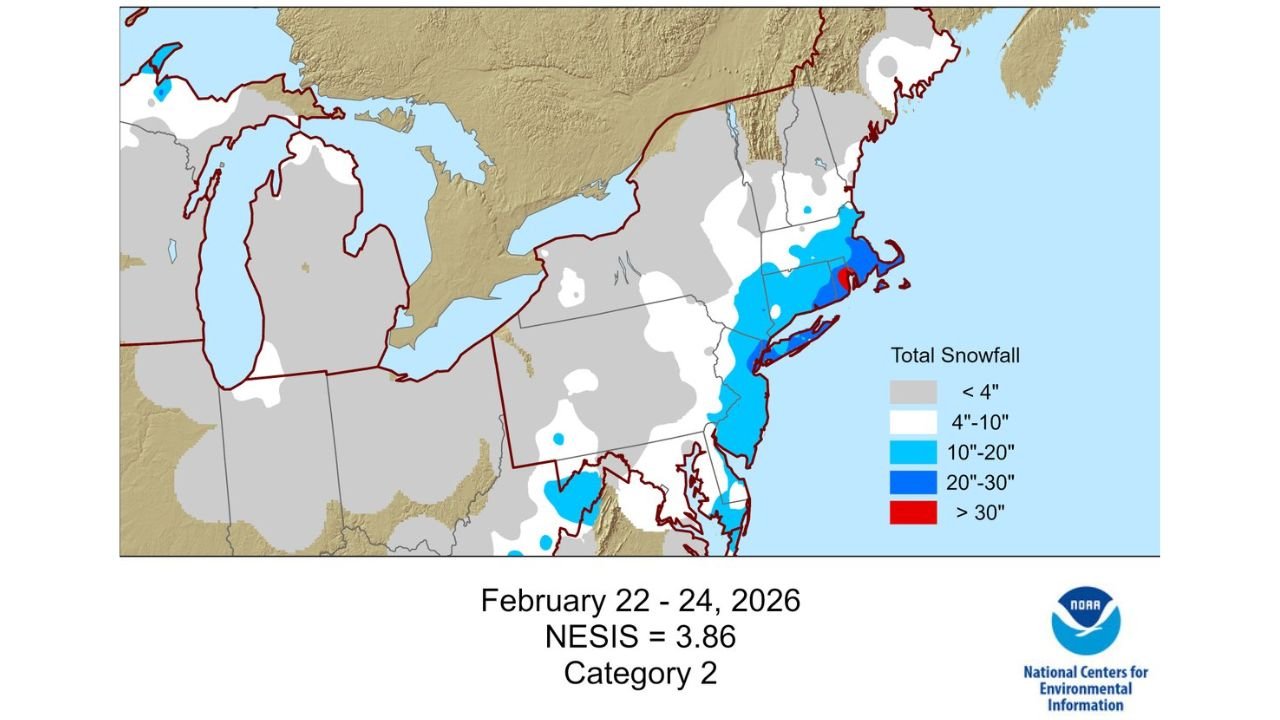
According to newly updated data, the February 22 to 24, 2026 snowstorm has been assigned a NESIS rating of 3.86, placing it in Category 2 on the Northeast Snowfall Impact Scale.
What The Category 2 NESIS Ranking Means
The Northeast Snowfall Impact Scale (NESIS) is used to measure not just snowfall totals, but also:
- Population affected
- Geographic coverage
- Overall societal impact
A Category 2 rating indicates:
- A moderate but significant winter storm
- Widespread disruptions across multiple states
- Noticeable impacts on travel, infrastructure, and daily life
Snowfall Spread Across Major Northeast Corridor
Data from the storm shows a broad area of snowfall impacting much of the Northeast:
- Light snowfall under 4 inches extended across parts of the Great Lakes and interior regions
- Moderate snowfall between 4 and 10 inches covered large portions of Pennsylvania and upstate New York
- Heavier snowfall of 10 to 20 inches impacted areas from the Mid-Atlantic into southern New England
- Localized bands exceeding 20 to 30 inches and even over 30 inches were recorded in parts of coastal and southern New England, including areas near Massachusetts and surrounding states
This distribution highlights how the storm intensified as it moved east, bringing its heaviest snowfall to densely populated coastal regions.
Heaviest Impacts Focused In New England and Coastal Areas
The most intense snowfall was concentrated across:
- Massachusetts and nearby coastal areas
- Portions of Connecticut and Rhode Island
- Parts of eastern New York and New Jersey
These areas experienced:
- Heavy snow bands
- Reduced visibility during peak snowfall
- Travel disruptions due to accumulation and road conditions
Why This Storm Stands Out
Although not the most extreme category, this storm is significant because:
- It impacted a densely populated region of the United States
- Snowfall totals varied widely, creating uneven but impactful conditions
- It added to ongoing winter weather patterns across the Northeast
The NESIS system specifically highlights storms that affect large populations, making this event notable even without reaching the highest categories.
Reminder Of Ongoing Winter Weather Risks
This classification serves as a reminder that:
- Even mid-level storms can cause widespread disruption
- Heavy snow in urban corridors can significantly impact transportation and daily routines
- Late-season winter systems can still bring major snowfall events
Residents Encouraged To Stay Prepared For Future Storms
While this particular storm has already passed, officials stress the importance of staying prepared for future winter weather events.
Residents across the Northeast should:
- Monitor forecasts during active weather patterns
- Prepare for travel disruptions during snow events
- Keep emergency supplies ready during winter months
As updated records continue to track impactful storms, this February event now stands as a clear example of how moderate-category systems can still deliver significant snowfall and widespread effects across the Northeast United States.