
Northern Oklahoma and Southern Kansas Residents Urged To Stay Alert As Evening Supercell Risk Could Bring Large Hail and Possible Tornado
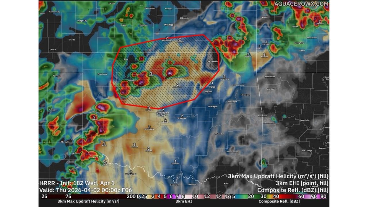
OKLAHOMA — Residents across northern Oklahoma and southern Kansas, including areas near Enid, Ponca City, Tulsa, and Wichita, are being advised to stay alert this evening as conditions may support the development of isolated supercell thunderstorms ahead of a dryline.
While storm coverage is expected to remain limited, any storm that forms could quickly become severe, bringing large hail and a localized tornado threat.
Supercell Development Possible Ahead of Dryline
Forecast analysis highlights a focused zone of concern stretching across:
- North-central and northeastern Oklahoma
- Extending into southern Kansas
Storms are expected to:
- Develop ahead of a dryline boundary
- Remain isolated rather than widespread
- Have the potential to evolve into supercells, which are capable of producing more intense weather hazards
Large Hail Expected As Primary Threat
The most likely hazard with these storms is:
- Large to very large hail, potentially significant in size
Atmospheric data shows strong updraft potential, meaning storms that develop could:
- Grow rapidly in intensity
- Produce hail capable of damaging vehicles, roofs, and crops
Tornado Risk Cannot Be Ruled Out
Although hail is the primary concern, forecast parameters also indicate:
- Strong wind shear and rotation potential
- Favorable conditions for storm organization and rotation
This means:
- A brief or isolated tornado could develop, especially within any sustained supercell
- Tornado potential will depend on whether storms can fully organize before merging or weakening
Favorable Environment For Rotating Storms
Detailed atmospheric profiles show:
- Sufficient instability to support storm growth
- Wind patterns that favor storm rotation
- A setup consistent with classic Plains supercell environments
These ingredients increase confidence that storms, if they form, could become organized and potentially dangerous quickly.
Timing Focused On Evening Hours
The main window for storm development is expected:
- This evening into early nighttime hours
Storms may:
- Initiate late in the day
- Intensify quickly during the evening
- Move northeast toward southern Kansas if they persist
Residents Advised To Monitor Conditions Closely
People across northern Oklahoma and southern Kansas should take precautions even though storm coverage may be limited.
Recommended actions:
- Stay updated with real-time weather alerts
- Be prepared for rapid storm development
- Identify a safe shelter location in advance
- Do not ignore warnings, even if storms appear isolated
Isolated Storms Can Still Bring Significant Impacts
This setup highlights a situation where not everyone will see storms, but those who do could experience intense and potentially dangerous weather.
Even a single supercell in this environment could produce:
- Large hail
- Damaging winds
- A brief tornado
Residents are encouraged to remain weather-aware throughout the evening as conditions evolve across the region.