
Oklahoma Residents Placed On Alert As Numerous Severe Storms Could Bring Tornadoes, Large Hail and 75 MPH Winds Tonight
OKLAHOMA — Residents across much of central, northern, and western Oklahoma, including Oklahoma City, Tulsa, Enid, Stillwater, Lawton, and Ponca City, are being urged to stay weather-aware as numerous severe storms are expected to develop late today and continue into the overnight hours.
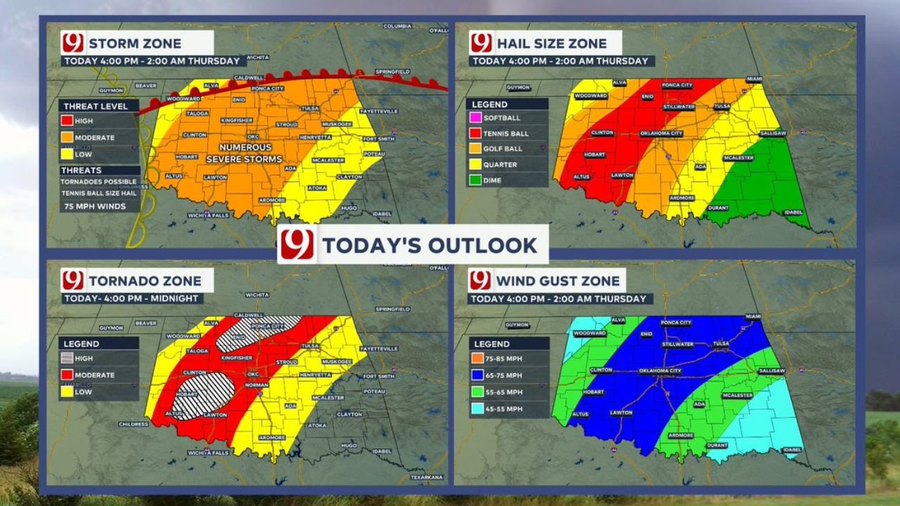
Forecast outlooks show a widespread severe weather setup capable of producing multiple hazards, with the most intense conditions expected from late afternoon into the night.
Storms Expected To Develop Late Afternoon And Continue Overnight
The primary timing window for severe weather is:
- 4 PM through 2 AM Thursday
During this period:
- Storms are expected to initiate across western Oklahoma
- Expand eastward and northeastward across central and northern parts of the state
- Continue into the overnight hours with ongoing severe potential
Multiple Hazards Expected Across Oklahoma
Forecast data highlights several serious threats:
- Tornadoes possible, especially in central and western Oklahoma
- Large hail ranging from golf ball to tennis ball size, with the largest hail expected in western zones
- Damaging wind gusts reaching 75 mph or higher
- Potential for numerous severe storms rather than isolated activity
This combination makes tonight’s setup particularly concerning, as multiple storms could produce severe conditions simultaneously.
Highest Tornado Risk Focused In Central And Western Oklahoma
The tornado outlook identifies:
- A moderate to high-risk zone stretching from western Oklahoma into central areas including Oklahoma City
- Additional embedded zones of higher concern within this corridor
Areas near:
- Clinton, Hobart, Lawton, Norman, and Oklahoma City
are most likely to see conditions favorable for tornado development.
Large Hail Corridor Extends Across Western And Central Oklahoma
The hail risk map shows:
- Tennis ball size hail possible in western Oklahoma
- Golf ball size hail extending into central areas
- Smaller but still damaging hail possible farther east
This indicates strong updrafts within storms, capable of producing significant hail damage.
Damaging Winds Likely Across A Broad Area
Wind threat projections show:
- 65 to 75 mph winds across central Oklahoma including Oklahoma City and Tulsa
- Higher-end gusts up to 85 mph possible in localized areas
- Slightly lower but still impactful winds extending into southern and eastern Oklahoma
Numerous Storms Increase Overall Risk
Unlike isolated storm setups, this system is expected to produce:
- Multiple storms across a wide area
- Increased chances of repeated impacts in some locations
- Greater likelihood of overlapping hazards including wind, hail, and tornadoes
Residents Urged To Prepare Before Storms Arrive
People across Oklahoma should take immediate precautions:
- Ensure you have multiple ways to receive weather warnings
- Identify a safe shelter location, especially for tornado risk
- Charge mobile devices and stay updated throughout the evening
- Avoid travel during peak storm hours if possible
Overnight Severe Threat Requires Extra Awareness
With storms continuing into the late night and early morning hours, residents are advised to remain alert even after dark.
This setup could bring dangerous and fast-moving storms across Oklahoma, making it critical for communities to stay prepared and respond quickly to any warnings issued.