
Iowa Missouri and Illinois Residents Placed On Alert As Tornado Threat Intensifies With Strong Tornado Potential This Afternoon
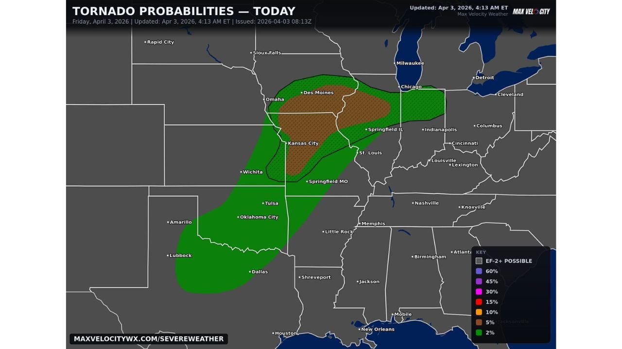
UNITED STATES — Residents across Iowa, Missouri, and Illinois are being urged to stay on high alert today as a rapidly intensifying severe weather setup is now focusing a dangerous tornado corridor across the Midwest, with the potential for multiple tornadoes including a strong one.
The threat has become more concentrated compared to earlier forecasts, with a defined corridor of concern stretching from eastern Kansas through Missouri into Iowa and western Illinois.
Focused Tornado Corridor Now Emerging Across Midwest
The highest concern zone now includes:
- Des Moines and central Iowa
- Kansas City and surrounding Missouri areas
- Springfield, Missouri
- St. Louis and nearby regions in eastern Missouri and western Illinois
This corridor is expected to see:
- Increasing storm development this afternoon
- Rapid intensification as storms track eastward
- A higher likelihood of rotating supercells capable of producing tornadoes
Strong Tornado Cannot Be Ruled Out
Forecast data indicates:
- Elevated tornado probabilities within the core zone
- A growing signal for a strong tornado, especially within the most favorable environment
- Conditions supportive of organized, long-lived storm structures
This makes today’s setup particularly concerning compared to more scattered or weaker severe weather events.
Storms Expected To Intensify Quickly This Afternoon Into Evening
The main timing window includes:
- This afternoon through the evening hours
During this time:
- Storms may form quickly and strengthen rapidly
- Supercells could develop and track east across Missouri into Illinois
- Tornado potential will peak as storms mature later in the day
Additional Hazards Include Large Hail And Damaging Winds
In addition to tornado risk, storms may also produce:
- Large hail capable of causing property damage
- Damaging wind gusts that could impact a wide area
- Fast-moving storms that may reduce warning lead times
Cities In Path Should Remain Especially Alert
Residents in and around the following cities should be particularly prepared:
- Des Moines
- Kansas City
- Springfield
- St. Louis
These areas sit within or near the highest probability zone for severe weather impacts today.
Rapidly Changing Conditions Increase Risk
This setup is dynamic, meaning:
- Conditions can shift quickly within hours
- Storm intensity may increase faster than expected
- Tornado risk could escalate rapidly once storms initiate
Residents Urged To Take Immediate Precautions
People across Iowa, Missouri, and Illinois should act now to prepare:
- Keep weather alerts enabled and accessible
- Identify a safe shelter location immediately
- Stay updated throughout the afternoon and evening
- Be ready to respond quickly if warnings are issued
High Impact Severe Weather Event Possible Today
With a focused corridor, increasing instability, and strong wind dynamics in place, today could bring a significant severe weather event across parts of the Midwest, especially where storms become established.
Stay with WaldronNews.com for continuous updates, tornado alerts, and critical safety information as this developing situation unfolds across Iowa, Missouri, and Illinois.