
Iowa Missouri and Illinois Residents Urged To Stay Alert As Enhanced Severe Storm Risk Brings Tornado and Large Hail Threat Today
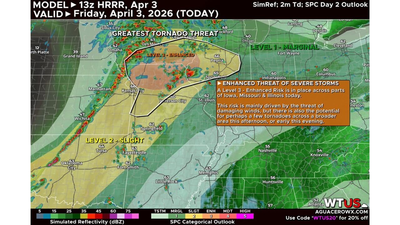
UNITED STATES — Residents across Iowa, Missouri, and Illinois are being placed on alert once again as another round of severe weather targets the Midwest today, with an Enhanced Risk (Level 3) now in place across key parts of the region.
This setup is expected to bring damaging winds, large to very large hail, and a few tornadoes, with the highest concern centered across a focused corridor stretching through the central Midwest.
Enhanced Risk Zone Focused Across Iowa Missouri And Illinois
The primary threat area includes:
- Southern Iowa including Des Moines
- Northern Missouri including Kansas City
- Western and central Illinois including Peoria and surrounding areas
This region has been identified as the core of today’s severe weather threat, where conditions are most favorable for organized storms capable of producing multiple hazards.
Damaging Winds Expected To Be Main Threat
Forecast data indicates:
- Damaging wind gusts will be the most widespread hazard
- Storms may produce sporadic but intense wind damage across multiple areas
- Some storms could organize into clusters, increasing the coverage of wind impacts
Large Hail And Tornado Risk Also Present
In addition to wind, storms may also bring:
- Large to very large hail, especially in stronger storm cores
- A few tornadoes, particularly in areas where storms can briefly organize
While tornado coverage may be limited, the environment supports:
- The possibility of a stronger tornado or two, especially in the most favorable zones
Greatest Tornado Concern Near Warm Front Zone
The highest tornado risk is expected near a warm frontal boundary, specifically across:
- Northern Missouri
- Southern Iowa
- Western to central Illinois
This area already carries a 5% tornado probability, indicating:
- Increased likelihood of tornado development compared to surrounding regions
- Enhanced conditions for storm rotation due to stronger wind shear near the boundary
If supercells can form in this zone, they may:
- Take advantage of favorable shear and instability
- Produce isolated but potentially stronger tornadoes
Storm Mode Likely Disorganized But Still Dangerous
Unlike classic supercell setups, today’s storms are expected to be:
- Messy and somewhat disorganized
- Forming in clusters rather than clean, isolated cells
- Producing sporadic severe weather impacts across a broad area
However:
- Any storm that becomes more organized could quickly turn severe
- Localized areas may experience more intense conditions than surrounding regions
Additional Storm Development Along Central Plains
Farther south along the cold front, including parts of the Central Plains, storms are expected to:
- Develop during the afternoon
- Quickly grow into semi-organized clusters
- Produce large hail and scattered damaging winds
A tornado cannot be ruled out in this region, though the risk is lower compared to the Midwest corridor.
Residents Urged To Stay Prepared Throughout The Day
People across Iowa, Missouri, and Illinois should take precautions now:
- Keep weather alerts enabled and accessible
- Identify a safe shelter location immediately
- Monitor conditions closely through the afternoon and evening
- Be ready to act quickly if warnings are issued
Another Active Severe Weather Day Across The Midwest
With an Enhanced Risk in place and multiple hazards expected, today represents another active and potentially impactful severe weather day across the central United States.
Stay with WaldronNews.com for continuous updates, severe weather alerts, and critical safety information as storms develop across Iowa, Missouri, and Illinois.