
Kansas Missouri Iowa Oklahoma and Illinois Residents Urged To Take Action As Significant Severe Storm Threat Brings Strong Tornado Risk Today
UNITED STATES — A significant severe weather threat is unfolding today across the Midwest and Southern Plains, with residents in Kansas, Missouri, Iowa, Oklahoma, and Illinois being urged to prepare immediately as conditions support strong tornadoes and widespread damaging winds.
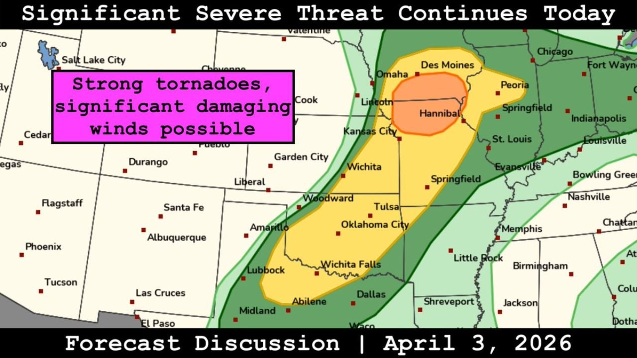
Forecast analysis shows a broad but dangerous corridor of severe weather stretching from Oklahoma and Kansas northeast into Missouri, Iowa, and Illinois, with multiple hazards expected throughout the day.
Strong Tornado Risk Highlighted Across Missouri And Iowa Corridor
The most concerning zone for tornado activity is focused across:
- Northern Missouri including areas near Kansas City and Hannibal
- Southern to central Iowa including Des Moines
- Extending into portions of western Illinois
Within this corridor:
- Strong tornadoes are possible
- Storms may become organized and long-lived
- Conditions favor rotating supercells capable of producing significant impacts
This region sits within the most favorable overlap of instability and wind shear, increasing the likelihood of higher-end severe weather.
Severe Threat Extends South Into Oklahoma And Kansas
Further south, severe storms are expected across:
- Oklahoma including Oklahoma City and Tulsa
- Kansas including Wichita and surrounding areas
In this region:
- Storms may develop along a north-south corridor ahead of a frontal boundary
- Hazards will include damaging winds, large hail, and isolated tornadoes
- Storms may organize into clusters while still producing localized severe impacts
Damaging Winds Expected To Be Widespread Hazard
Across the entire risk area, the primary concern includes:
- Significant damaging wind gusts capable of causing widespread disruption
- Fast-moving storms that could produce power outages and structural damage
- Expanding storm lines increasing the coverage of wind impacts
All Severe Weather Hazards Remain Possible Today
This setup is particularly dangerous because:
- It supports all modes of severe weather simultaneously
- Storms may transition between discrete supercells and organized lines
- Conditions may evolve quickly throughout the day
Potential hazards include:
- Strong tornadoes
- Large hail
- Damaging straight-line winds
Uncertainty Could Influence Storm Intensity
Forecasters note that:
- Some atmospheric factors may limit the overall intensity in certain areas
- However, even with these uncertainties, the environment still supports significant severe weather potential
This means:
- Not every location will see the worst conditions
- But areas that do could experience high-impact storms with little warning
Residents Across Multiple States Urged To Stay Prepared
People across Kansas, Missouri, Iowa, Oklahoma, and Illinois should take precautions now:
- Ensure you have multiple ways to receive severe weather alerts
- Identify a safe shelter location immediately
- Monitor weather conditions closely throughout the day
- Be ready to act quickly if warnings are issued
Dangerous Weather Day Unfolding Across Central United States
With a broad risk area and multiple hazards expected, today represents a high-impact severe weather day across the central United States, especially in the Missouri and Iowa corridor where the tornado threat is greatest.
Stay with WaldronNews.com for real-time updates, tornado warnings, and critical safety information as this dangerous severe weather event continues to develop.