
Kansas Missouri Residents Put On Alert As 4PM Storm Line Targets Kansas City With Tornado Wind And Hail Threat
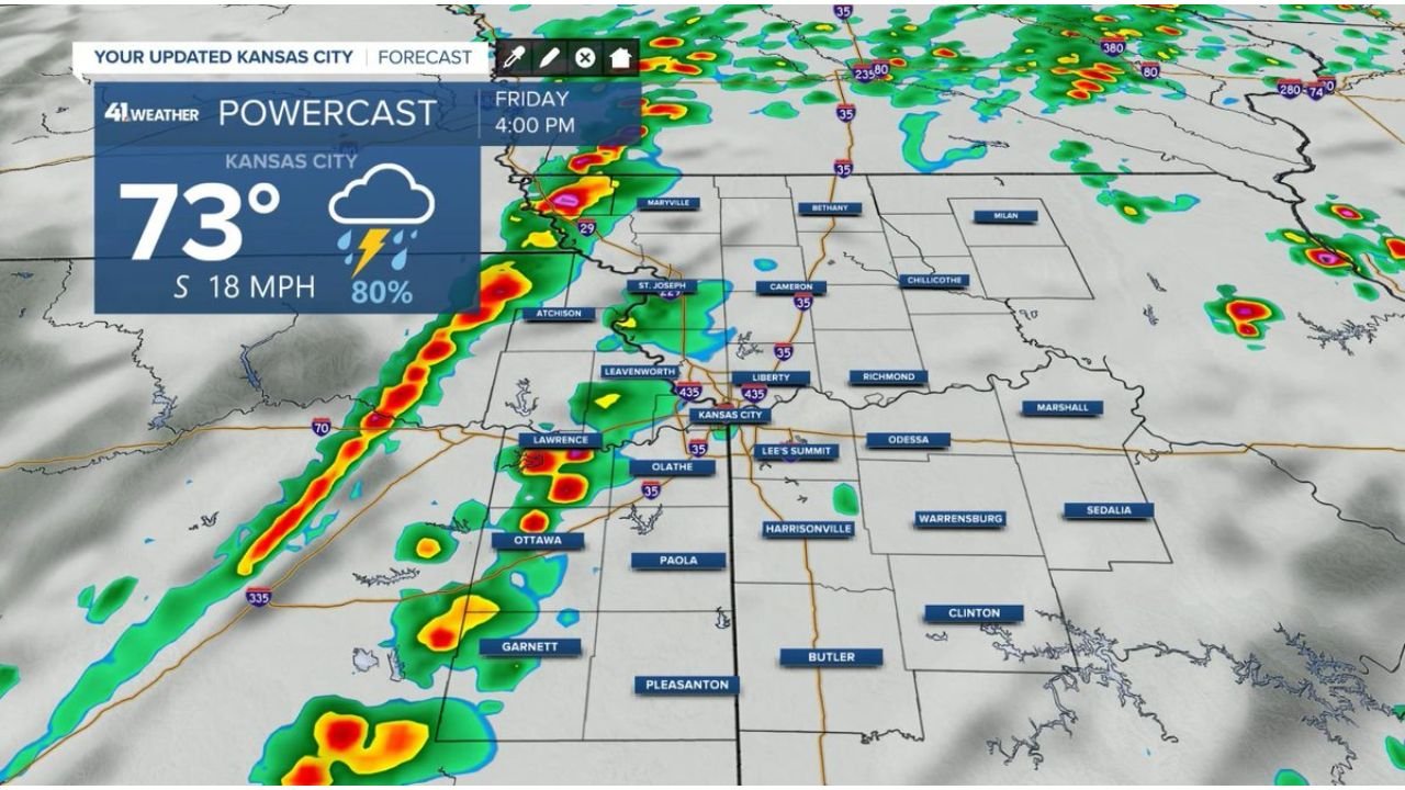
KANSAS CITY, MISSOURI — A developing line of thunderstorms is expected to move into the Kansas City metro area after 3 PM today, bringing a serious risk of damaging winds, hail, and possible tornadoes across parts of Kansas and Missouri.
This setup is shaping into a fast-moving but potentially dangerous afternoon and evening weather event, with storms already organizing to the west and pushing toward populated areas.
Storm Line Targets Kansas City During Peak Hours
Forecast data shows a well-defined line of storms forming west of Kansas City, stretching from eastern Kansas and moving northeast.
Key impacted areas include:
- Kansas City metro (Missouri & Kansas)
- Lawrence, Olathe, and Overland Park
- St. Joseph and surrounding northern Missouri communities
The timing is critical, with storms expected to:
- Begin impacting western metro areas shortly after 3 PM
- Move through Kansas City between 4 PM and early evening
- Continue eastward into Missouri later tonight
Primary Threats With These Storms
As this line strengthens, multiple severe hazards are expected:
Damaging Winds
- Wind gusts could exceed 60–70 mph
- Potential for tree damage and power outages
Large Hail
- Stronger storm cores may produce hail capable of damaging vehicles and property
Tornado Potential
- While not widespread, isolated tornadoes cannot be ruled out, especially in embedded circulations along the line
Storm Structure Suggests Fast-Moving Impact
The radar simulation shows a linear storm mode, meaning:
- Storms may organize into a squall line
- The main threat becomes widespread wind damage
- Quick-moving storms reduce warning time, making real-time alerts critical
However, embedded rotation within the line could still produce brief tornado spin-ups, particularly near the leading edge.
Conditions Favor Strong Storm Development
Atmospheric conditions ahead of the storm line include:
- Warm temperatures around the low 70s
- Increasing moisture and instability
- Strong wind flow feeding into the storms
These factors will allow storms to maintain strength as they move into the Kansas City region.
Residents Should Prepare Before Storms Arrive
With storms arriving during the late afternoon and evening, preparation time is limited.
Residents are strongly urged to:
- Enable weather alerts on mobile devices
- Identify a safe shelter location indoors
- Stay alert for rapid warning updates
A Critical Afternoon For Kansas City Region
This is not a slow-moving system — it is a quick-hitting severe weather event that could intensify rapidly as it reaches populated areas.
Even short-lived storms in this setup can produce significant impacts within minutes.
Stay with WaldronNews.com for real-time severe weather updates, radar tracking, and urgent alerts as storms move across Kansas and Missouri this afternoon and evening.