
Kansas Missouri Residents Urged To Stay Alert As 3PM To 9PM Severe Storm Window Targets Kansas City With Damaging Winds And Tornado Risk
KANSAS CITY, MISSOURI — A heightened severe weather threat is expected across Kansas and Missouri this evening, with storms developing between 3 PM and 9 PM and bringing damaging winds, large hail, and a possible tornado risk to the Kansas City metro and surrounding areas.
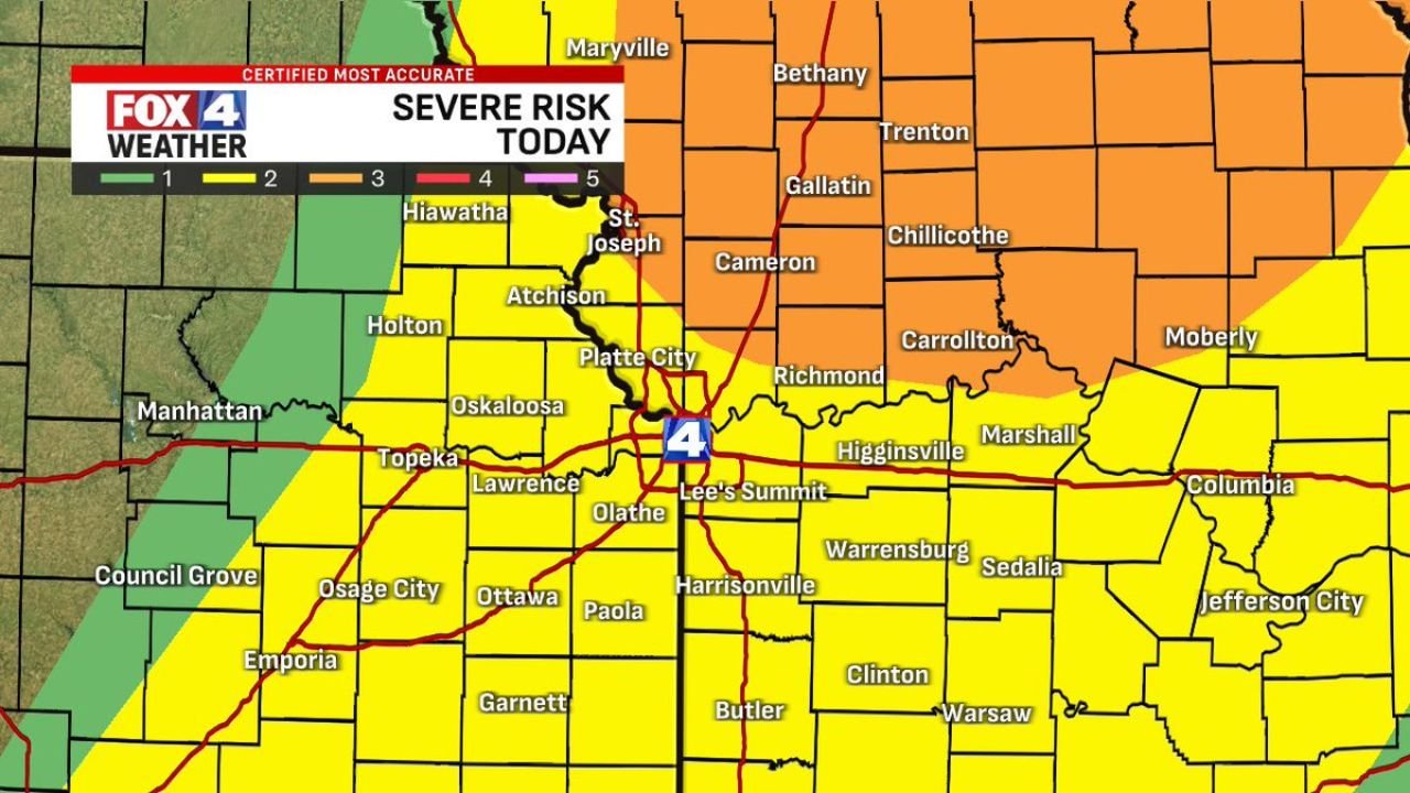
This setup places much of the region under a Level 2 risk, with a more concerning Level 3 enhanced risk extending into northern Missouri, signaling a greater potential for impactful storms.
Kansas City Metro Faces Peak Impact Around Early Evening
Storm timing suggests the Kansas City area will see its most active weather window between:
- 6 PM and 7 PM in the KC Metro
- Earlier impacts beginning west of the city after 3 PM
Communities likely to be affected include:
- Kansas City (Missouri & Kansas)
- Overland Park, Olathe, Lee’s Summit
- Lawrence, Topeka, and surrounding eastern Kansas areas
- St. Joseph and northern Missouri towns
Primary Threat Is Damaging Winds Across The Region
The dominant concern with this system is strong straight-line winds, with potential impacts including:
- Wind gusts reaching 60 mph or higher
- Downed trees and scattered power outages
- Rapid storm movement increasing impact speed
Large Hail And Tornado Risk Cannot Be Ruled Out
While winds are the primary hazard, atmospheric conditions also support:
- Large hail in stronger storm cores
- Isolated tornado potential, especially within the enhanced risk zone in northern Missouri
These threats may develop quickly, particularly in storms that briefly intensify ahead of the main line.
Northern Missouri Under Enhanced Risk
Areas north of Kansas City, including:
- St. Joseph
- Chillicothe
- Trenton and surrounding communities
are under a Level 3 (Enhanced) risk, meaning:
- Greater likelihood of organized severe storms
- Increased chance for more intense wind damage
- A slightly higher probability of tornado development
Storms Will Bring Frequent Lightning And Rapid Changes
In addition to severe hazards, storms are expected to produce:
- Frequent lightning
- Heavy rain bursts reducing visibility
- Rapid changes in conditions within minutes
Residents Should Prepare Before Storms Arrive
With storms expected during the late afternoon and early evening, preparation should be completed early.
Residents are urged to:
- Turn on weather alerts and notifications
- Identify a safe indoor shelter location
- Stay updated as storms approach quickly from the west
A Fast-Moving Evening Threat Across Kansas And Missouri
This system is expected to be fast-moving and impactful, meaning storms may intensify quickly and move through communities with little warning time.
Even short-lived storms could produce significant damage in a brief window, especially during peak evening hours.
Stay with WaldronNews.com for real-time severe weather updates, radar tracking, and urgent alerts as storms move across Kansas and Missouri this evening.