
Urgent Mid-April Storm Alert Building Across Texas Louisiana Mississippi And Arkansas As Explosive Instability Signals Dangerous Setup
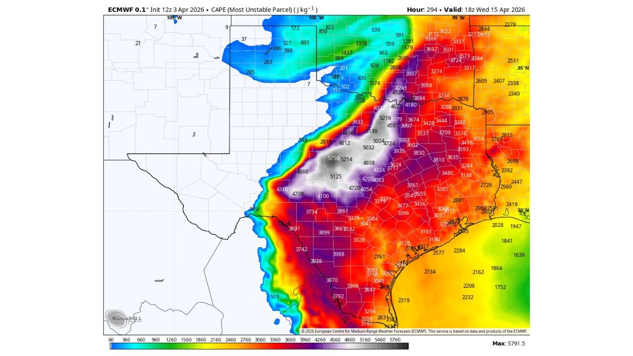
UNITED STATES — A potentially dangerous severe weather setup is beginning to emerge across the Southern Plains and Deep South, with new data showing extremely high atmospheric instability developing by mid-April.
Forecast guidance valid around April 15 highlights a rapidly intensifying environment stretching across Texas, Louisiana, Mississippi, and Arkansas, raising early concerns for significant severe weather potential.
Explosive Instability Signals Across The South
The latest data shows a large zone of very high instability (CAPE values) expanding across the region, including:
- Eastern Texas
- Northern and central Louisiana
- Mississippi
- Southern and central Arkansas
Values in this region are projected to reach 3000 to over 5000+ J/kg, which is considered extremely unstable and supportive of strong to severe storm development.
This level of energy in the atmosphere is often associated with:
- Rapid thunderstorm intensification
- Strong updrafts capable of producing severe weather
- Increased potential for organized storm systems
Sharp Boundary Setting Up Storm Corridor
A noticeable feature in the data is a sharp gradient between stable and unstable air, positioned from:
- Central Texas
- Through Arkansas
- Into parts of the Lower Mississippi Valley
This boundary acts as a trigger zone, where storms are more likely to develop and intensify quickly.
Areas just east of this boundary — including Louisiana and Mississippi — appear to be in the most favorable environment for stronger storms.
Southern States Could See Highest Impact Risk
The corridor of concern currently includes:
- Dallas–Fort Worth region and East Texas
- Shreveport and northern Louisiana
- Jackson and central Mississippi
- Little Rock and central Arkansas
These areas sit within the zone of peak instability, meaning any storms that form here could strengthen rapidly.
Pattern Supports Organized Severe Weather Potential
This is not just a random spike in instability — it is part of a larger developing pattern, which suggests:
- A coordinated storm system may emerge
- Conditions could favor clusters or lines of severe storms
- The setup could evolve into a multi-state severe weather event
While specific hazards will depend on additional factors, setups like this commonly support:
- Damaging winds
- Large hail
- Tornado potential
Timing Window Becoming Clearer
The current projection centers around:
- Mid-April, especially April 14–15
- Peak conditions likely during afternoon and evening hours
As the system approaches, timing and exact risk zones will become more refined.
Early Warning Stage — But Signals Are Strong
Although this is still several days out, the strength and consistency of the signal stand out:
- Multiple indicators point toward a volatile setup
- The instability levels are well above typical thresholds
- The region affected includes densely populated areas
This is the kind of pattern that requires close monitoring in the days ahead.
What To Watch Next
Key things that will determine how serious this becomes:
- Strength of the storm-triggering system
- Wind shear alignment (important for tornado risk)
- Exact placement of the instability axis
These details will sharpen as newer data becomes available.
Prepare For Possible Severe Weather Updates
Residents across Texas, Louisiana, Mississippi, and Arkansas should:
- Stay alert for updated forecasts
- Review severe weather safety plans
- Be ready for possible watches or warnings as we get closer
Stay with WaldronNews.com for continuous updates, real-time alerts, and detailed tracking as this mid-April severe weather threat develops across the Southern United States.