
Major Easter Weather Alert Issued From Texas to Maine as Rain and Record Heat Threaten Millions Across the U.S.
UNITED STATES — A major weather pattern is now taking shape heading into Easter weekend, with a powerful frontal system stretching from Texas all the way to Maine, bringing a combination of widespread rainfall and unusual early-season heat across a large portion of the country.
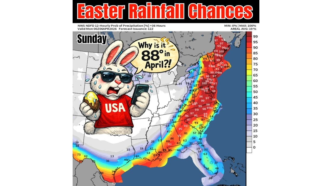
This setup is expected to impact millions, especially on Sunday, with rain chances increasing along the front while areas ahead of it experience summer-like temperatures rarely seen this early in April.
Warm Surge Builds Ahead of Incoming System
Before the rain arrives, much of the eastern half of the country will sit in a warm sector ahead of the front, allowing temperatures to surge well above seasonal averages.
- Parts of the Mid-Atlantic and Northeast are expected to climb into the 80s
- Some areas in Pennsylvania and surrounding states could challenge or break early April temperature records
- The warmth will feel more like late spring or early summer rather than Easter weekend
This unusual heat is being driven by strong southerly flow, pulling warm air northward ahead of the advancing system.
Frontal Line Stretches Coast to Coast
The system itself is highly organized, forming a long, continuous boundary from the Southern Plains through the Midwest and into the Northeast.
Key impacts along this boundary include:
- Widespread rain developing Sunday
- A corridor of higher precipitation chances from the Gulf Coast through the Appalachians into the Northeast
- Potential for locally heavier rainfall where the front slows or stalls
Areas from Texas, Louisiana, Mississippi, Alabama, Georgia, the Carolinas, Virginia, Pennsylvania, New York, and into New England are all within the zone of influence.
Easter Sunday Brings Increasing Rain Chances
As the front pushes eastward:
- Rain will begin spreading across the central and eastern U.S.
- The highest rain chances align closely with the frontal boundary itself
- Coastal areas and the Northeast may see widespread, steady rainfall by late Sunday into Sunday night
This could impact:
- Easter travel plans
- Outdoor gatherings
- Church services and holiday events
Timing will vary by location, but the general trend is increasing clouds followed by rain as the day progresses.
Sharp Contrast Across the Country
One of the most notable aspects of this setup is the dramatic contrast in conditions:
- Ahead of the front: Warm, humid, record-challenging temperatures
- Along the front: Rainfall and shifting winds
- Behind the front: Cooler and more stable air begins to move in
This creates a classic spring transition pattern, but with enhanced intensity due to the strength of the system.
What to Watch Going Forward
As this system evolves, a few key factors will determine impacts:
- Speed of the front — slower movement could increase rainfall totals
- Temperature contrast — sharper differences may enhance instability
- Moisture availability — could lead to heavier rain bands in some regions
While the current focus is on rain and warmth, additional updates could refine the exact placement of heavier rainfall zones.
Final Takeaway
This Easter weekend setup is shaping up to be a high-impact weather event across a large portion of the United States, combining unseasonable heat and widespread rain along a powerful front stretching from Texas to Maine.
Anyone with travel or outdoor plans should stay alert to changing conditions, especially on Sunday as the system moves through.
Stay with WaldronNews.com for the latest real-time updates, regional breakdowns, and detailed forecasts as this Easter weather system continues to develop.