
Florida Rain Alert Issued for Miami, Orlando and Tampa as Stalled Front Could Trigger Flooding Risks This Week
FLORIDA — A developing weather setup is raising concern across the state as a frontal boundary is expected to stall over the Florida Peninsula during the upcoming work week, bringing the potential for periods of heavy rain and localized flooding.
This pattern is not a fast-moving system. Instead, it is expected to linger over the same region, increasing the risk for repeated rounds of rainfall across cities including Miami, Fort Lauderdale, West Palm Beach, Orlando, Tampa, and surrounding areas.
What We Know Right Now
Current forecast guidance highlights a few key points:
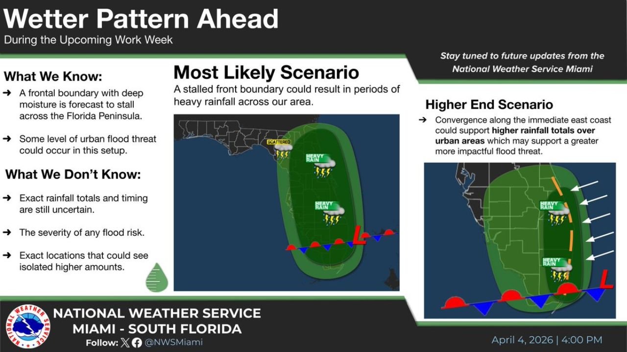
- A frontal boundary will slow down and stall across Florida
- Deep tropical moisture will be pulled into the region
- This combination creates a setup for multiple rounds of rain over several days
Because the front is not expected to move quickly, rainfall could repeat over the same locations, increasing the chance of water buildup.
Flooding Risk Begins to Enter the Picture
One of the biggest concerns with this setup is urban flooding, especially in heavily populated areas.
- Cities like Miami, Fort Lauderdale, and Tampa are more vulnerable due to drainage limitations
- Repeated downpours could lead to ponding on roads and localized flooding issues
- Low-lying and poor drainage areas may experience quick water accumulation
While widespread flooding is not guaranteed yet, the setup is one that often leads to isolated problem areas.
Most Likely Scenario: Periods of Heavy Rain
The most likely outcome based on current trends includes:
- On-and-off rounds of showers and thunderstorms
- Periods of moderate to heavy rainfall throughout the week
- Increasing rain coverage along the central and southern Florida Peninsula
This type of pattern typically leads to inconsistent but impactful rainfall, where some areas see significantly more rain than others.
Higher-End Scenario Still Possible
There is also a more concerning possibility if conditions align:
- Rain bands could focus along the east coast of Florida
- This would increase the risk of higher rainfall totals in urban corridors
- A more concentrated setup could lead to more impactful flooding in cities
At this stage, this higher-end outcome is not certain, but it remains within the range of possibilities.
What Remains Uncertain
Despite growing confidence in the pattern, several important details are still unclear:
- Exact rainfall totals across different regions
- Timing of the heaviest downpours
- Which specific locations could see repeated storm activity
These factors will determine how serious the flooding risk becomes.
What Residents Should Watch
As the week progresses, residents across Florida should monitor:
- Updates on rainfall totals and storm timing
- Any flood advisories or warnings
- Changes in where the heaviest rain bands set up
Because this is a slow-moving pattern, conditions can evolve quickly depending on how the boundary behaves.
Final Outlook
Florida is entering a potentially wet and unsettled stretch of weather, with a stalled front capable of producing multiple rounds of rain and localized flooding concerns throughout the work week.
While uncertainty remains, the setup is one that residents across Miami, Orlando, Tampa, and surrounding areas should closely monitor.
Stay with WaldronNews.com for continuous updates as this developing Florida rain event becomes clearer in the days ahead.