
United States Tornado Outlook Texas Oklahoma Kansas Missouri and Arkansas Face Increasing Severe Storm Risk After April 11 As Quiet Period Ends
UNITED STATES — A notable shift in the nation’s severe weather pattern is underway, with tornado activity expected to drop off significantly over the next several days before ramping back up across key Plains and Midwest states by mid-April.
Forecast data indicates a temporary lull in tornado potential, followed by a renewed and more active severe weather setup beginning around April 11.
Quiet Stretch Ahead for Tornado Activity
In the short term, much of the United States will experience:
- A marked decrease in tornado risk
- Fewer organized severe weather setups
- More stable atmospheric conditions across typical storm regions
This quieter period is expected to last for about a week, offering a break after recent active conditions.
Mid-April Pattern Signals Strong Comeback
By around April 11, weather patterns are expected to shift again, bringing back a more classic severe weather setup.
Key drivers include:
- Return of western U.S. troughing
- Increasing warm air and moisture across the central and eastern U.S.
- Strengthening atmospheric dynamics supportive of storm development
This combination is known for fueling organized severe storms, including tornadoes.
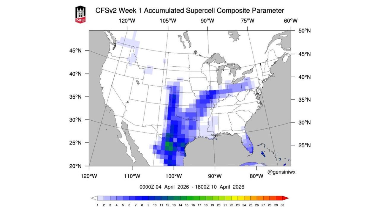
Southern Plains Likely to Become Focus Area
The data highlights the southern Plains as a primary region to watch, including:
- Texas
- Oklahoma
- Kansas
These areas may begin to see:
- More frequent storm days
- Development of dryline-driven thunderstorms
- Conditions favorable for supercell formation
This setup is often associated with higher-end severe weather potential during spring.
Storm Corridor Extending Into Midwest and Beyond
As the pattern evolves, the risk zone could extend into:
- Missouri
- Arkansas
- Portions of the Midwest and Lower Mississippi Valley
This suggests a broadening severe weather corridor, rather than isolated activity.
What This Means Going Forward
The current forecast points to a two-phase pattern:
- Short-term calm: Reduced tornado risk and quieter weather nationwide
- Mid-April escalation: Increasing storm chances with more organized severe setups
While exact storm timing and intensity will become clearer in the coming days, the signal for a more active period is becoming increasingly consistent.
Final Outlook
After a brief lull in tornado activity across the United States, attention is turning toward mid-April, when Texas, Oklahoma, Kansas, Missouri, and Arkansas could see a renewed surge in severe weather risk.
Residents in these regions should use the quieter period to stay prepared, as conditions may become more favorable for severe storms and tornado development heading into the second half of April.
Stay with WaldronNews.com for continuing coverage as this developing severe weather pattern takes shape across the country.