
Florida Flood Alert Issued as New Rainfall Forecast Expands Inland Threat Through April 10
FLORIDA — A newly updated rainfall outlook is signaling a growing flood threat across the Florida peninsula, with the highest concern no longer limited to coastal zones. Instead, inland regions are now being pulled into the risk area, prompting increased attention for residents across central and eastern parts of the state.
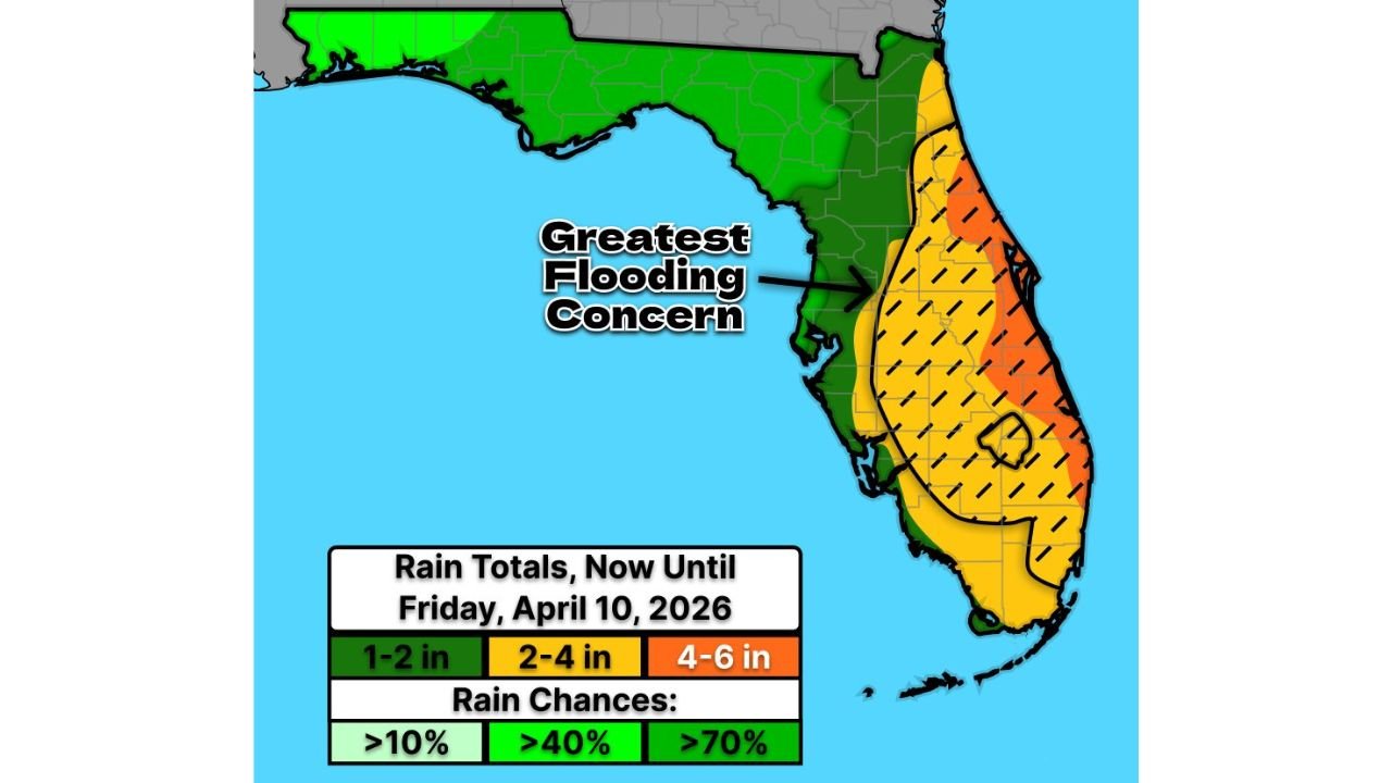
Flood Risk Expands Beyond the Coast
Recent forecast data shows that flooding potential is increasing and spreading inland, especially across:
- East-Central Florida
- Interior Peninsula regions
- Areas stretching from the Space Coast through the Treasure Coast and into central Florida
The latest projection highlights a broad zone of concern, with the most significant impacts expected where persistent rainfall bands set up.
Rainfall Totals Continue to Increase
Updated projections now indicate:
- 1 to 2 inches across parts of the western and northern peninsula
- 2 to 4 inches across much of central Florida
- 4 to 6 inches possible along the eastern side of the peninsula, including heavily populated corridors
Some localized areas could even exceed these totals where storms repeatedly move over the same locations.
Highest Concern Zone Clearly Defined
The greatest flooding concern is now focused on a wide corridor running through:
- Orlando metro region
- Palm Bay and surrounding inland areas
- Port Saint Lucie and nearby communities
- Interior zones just west of the Atlantic coastline
This zone is particularly vulnerable due to saturated ground conditions and repeated rainfall episodes.
Why the Risk Is Increasing
The concern is growing due to a combination of factors:
- Persistent moisture flow into the peninsula
- Slow-moving or repeated storm development
- Expansion of rainfall coverage further inland
As rainfall totals increase over multiple days, even areas that typically handle heavy rain could begin to see localized flooding, ponding on roads, and drainage issues.
Timing of the Event
The flood risk is expected to continue building over the next several days, with impacts lasting through Friday, April 10.
This extended duration is critical, as flooding risk increases when rain falls consistently over multiple days rather than in a single event.
Areas That Should Stay on Alert
Residents in the following regions should closely monitor conditions:
- East-Central Florida (Orlando, Palm Bay)
- Treasure Coast (Port Saint Lucie, surrounding areas)
- Interior Peninsula communities
- Portions of South Florida extending northward
Even areas outside the highest zone could still experience periods of heavy rain and localized flooding.
What This Means for Residents
With the flood zone expanding inland, residents should be prepared for:
- Water accumulation on roads and low-lying areas
- Slower travel conditions during heavy rainfall periods
- Rapid changes in localized conditions depending on storm placement
This is not just a coastal event anymore — the inland shift significantly increases the number of communities at risk.
Preparedness Is Key as Conditions Evolve
As rainfall forecasts continue to adjust upward, it’s important for residents to:
- Stay updated with local weather alerts
- Avoid flooded roadways
- Monitor drainage-prone areas near homes and neighborhoods
The evolving setup suggests that conditions could worsen if rainfall continues to overperform forecasts.
Ongoing Situation to Watch Closely
This developing situation across Florida highlights a broadening flood threat that is still evolving. With multiple days of rain ahead and expanding impact zones, the risk remains dynamic.
Stay with WaldronNews.com for the latest updates as this Florida flooding threat continues to develop through the week.