
Central Florida Now Under Wind Alert as 50+ MPH Gusts Target Orlando, Daytona Beach and Coastal Areas Tonight
CENTRAL FLORIDA — A dreary and unsettled weather pattern is continuing across the region, but the bigger concern is now shifting toward strong, potentially damaging winds expected to peak tonight into early Wednesday morning.
Rain has already moved through much of the area, with only lingering showers and light sprinkles expected overnight, especially around Orlando and areas east toward the coast. However, while rainfall is easing, wind intensity is set to increase significantly, making this a different kind of weather threat residents should be paying close attention to.
Strongest Winds Expected Tonight Across Central and Coastal Areas
The most impactful part of this system will arrive during the evening and overnight hours. Current projections show:
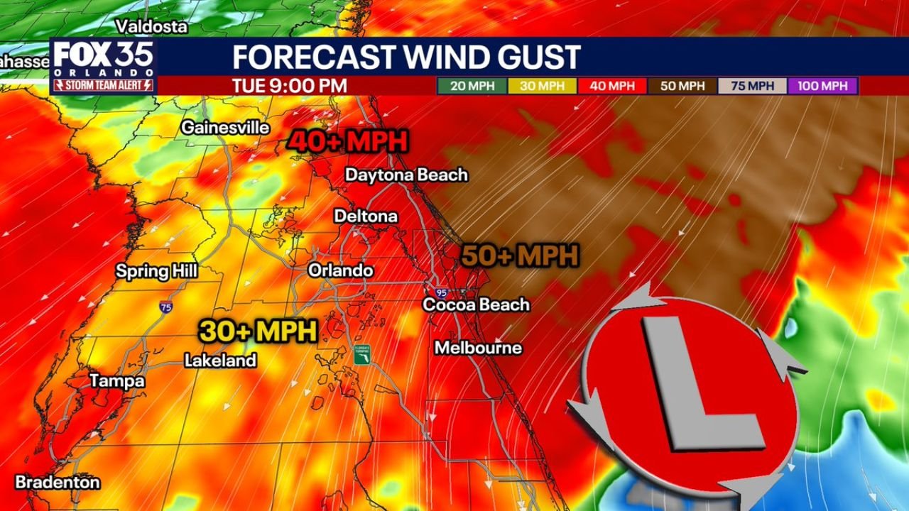
- Coastal areas including Cocoa Beach and Melbourne: Gusts could exceed 50+ MPH
- Orlando, Daytona Beach, Deltona corridor: Gusts around 40+ MPH
- Inland areas like Lakeland and parts of west-central Florida: Gusts near 30+ MPH
This increase in wind is tied to a strengthening pressure gradient and a nearby low-pressure system offshore, which is tightening wind flow across Central Florida.
Timing Window Residents Should Watch Closely
The most critical time frame for strong winds will be between 5 PM and 2 AM Wednesday, when conditions are expected to peak.
During this window:
- Winds will become more sustained and widespread
- Gusts could be strong enough to bring down small branches or unsecured objects
- Travel, especially on exposed roadways and bridges, may become more difficult
Even though this is not a severe thunderstorm outbreak, the wind threat alone is enough to create localized hazards, especially along the coast.
Coastal Areas Face the Highest Risk
The strongest winds will be concentrated along Florida’s Atlantic coastline. Locations such as:
- Daytona Beach
- Cocoa Beach
- Melbourne
will likely experience the highest gusts due to their proximity to the low-pressure system offshore. These areas could see the most consistent 50+ MPH gusts, particularly late tonight.
Meanwhile, inland cities like Orlando will still feel strong winds, but slightly weaker compared to coastal zones.
What This Means for Central Florida Residents
Even without heavy rain or severe storms, this type of wind event can still cause disruptions:
- Loose outdoor items may be blown around
- Tree limbs could snap, especially weaker or dead branches
- Power outages are possible in isolated areas
- Driving conditions may become hazardous during peak gusts
Residents are advised to secure outdoor furniture, trash bins, and any loose items before winds intensify this evening.
Conditions Begin to Improve After Early Wednesday
Winds will gradually begin to weaken after 2 AM Wednesday, though breezy conditions may linger into the morning hours. Skies are expected to slowly improve as the system moves away from the region.
However, until then, this remains a wind-driven weather event that deserves attention across Central Florida.
Stay alert tonight, especially if you’re near the coast or traveling during the peak wind window.