
Wisconsin and Michigan Rain Alert Issued as New Flood Risk Map Shows Heavy Weekend Rainfall Areas Residents Should Watch Closely
MICHIGAN — A new rainfall projection update is highlighting a developing flooding concern across parts of Wisconsin and Michigan this weekend, as a widespread rain system moves through the Upper Midwest.
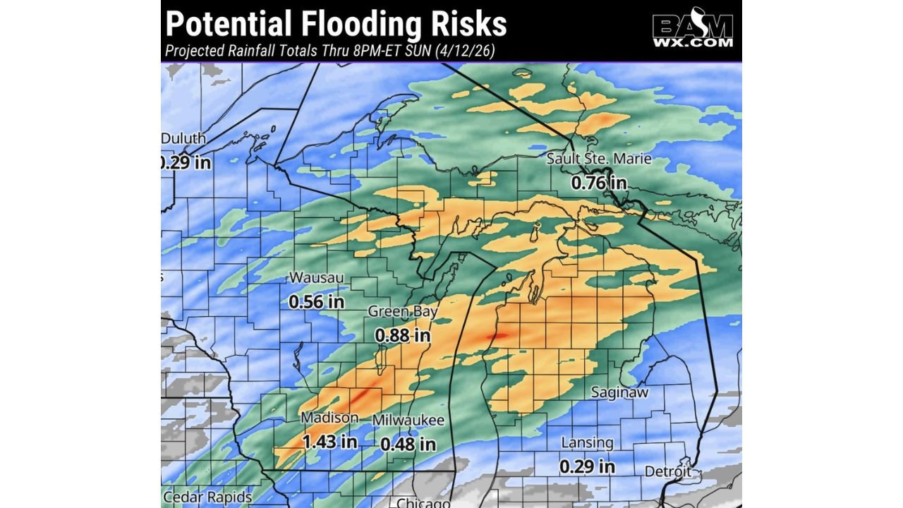
The latest data shows steady rainfall totals building across both states, with some areas potentially seeing over 1 to 2 inches of rain, raising concerns for localized flooding.
Rainfall Totals Increasing Across the Region
Forecast projections through Sunday evening (April 12) indicate:
- 1 to 1.5 inches of rain expected across large portions of Wisconsin and Michigan
- Localized totals up to 2 inches possible in heavier bands
- A broad zone of moderate rainfall stretching from southern Wisconsin into central Michigan
Cities and areas highlighted include:
- Madison, WI – around 1.43 inches
- Green Bay, WI – near 0.88 inches
- Wausau, WI – about 0.56 inches
- Sault Ste. Marie, MI – around 0.76 inches
Meanwhile, lighter totals are expected farther south and east, including:
- Lansing, MI – near 0.29 inches
- Milwaukee, WI – around 0.48 inches
Flooding Risk Becoming a Concern
While these rainfall amounts may not seem extreme at first glance, the concern comes from:
- Steady, prolonged rainfall over multiple days
- Saturated ground conditions in some areas
- Potential for heavier localized downpours within the system
This combination could lead to:
- Water pooling on roads
- Minor urban flooding
- Rising levels in smaller streams and low-lying areas
Heaviest Rain Corridor Identified
The most concerning zone currently appears to stretch from:
- South-central Wisconsin (Madison area)
- Through eastern Wisconsin (Green Bay region)
- Into parts of central and northern Michigan
This corridor is where the highest rainfall totals and strongest flooding signals overlap.
What to Expect This Weekend
- Periods of rain developing and continuing through the weekend
- Occasional heavier bursts embedded within the system
- Gradual accumulation rather than one intense storm
This type of setup often increases flooding risk because rain falls consistently over time instead of quickly moving out.
Key Timing
- Saturday: Rain begins spreading across Wisconsin and Michigan
- Saturday Night – Sunday: Heaviest rainfall expected
- Sunday Evening: System gradually begins to taper off
Final Outlook
A rainy and potentially impactful weekend is shaping up for Wisconsin and Michigan, with new forecast data pointing to localized flooding risks due to steady rainfall totals nearing or exceeding 2 inches in some areas.
Residents in Madison, Green Bay, Wausau, and parts of Michigan should stay alert, especially in flood-prone locations.
Continue following WaldronNews.com for the latest updates as this weekend rain system develops and conditions change.