
Nebraska and Kansas Tornado Watch Saturday as Supercells Capable of Strong Tornadoes and Large Hail Target Grand Island, Hastings, Topeka and Kansas City
KANSAS CITY, Missouri — A serious and active tornado threat is unfolding Saturday, April 11 across Nebraska and Kansas as forecasters warn that at least a couple of tornadoes are possible this afternoon and evening — and a strong tornado cannot be ruled out — as supercell thunderstorms develop across a largely uncapped, moderately sheared atmospheric environment primed for dangerous storm activity.
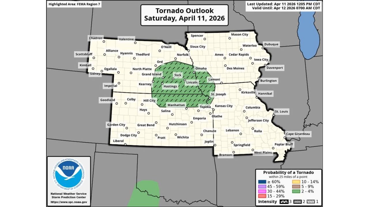
The Storm Prediction Center (NOAA/NWS) has issued a formal Tornado Outlook valid through 7:00 AM CDT Sunday, April 12, placing a significant tornado probability zone across central Nebraska and northeast Kansas, with the highest risk corridor centered on cities including Grand Island, Hastings, York, Lincoln, Omaha, Manhattan, Topeka, and the Kansas City metro area.
Cities and States in the Risk Zone
- Nebraska: Grand Island, Hastings, York, Lincoln, Omaha, Kearney, North Platte, Beatrice, Ord, and Norfolk all fall within the tornado probability zone
- Kansas: Manhattan, Topeka, Junction City, Concordia, Salina, and the broader northeast Kansas corridor are directly inside the risk area
- Missouri: Kansas City and St. Joseph sit on the eastern edge of the tornado threat zone
- Iowa: Areas near St. Joseph and southern Iowa fall within the broader risk corridor
Primary Threats
Saturday’s atmosphere is delivering a dangerous combination of ingredients that forecasters say is capable of producing organized, long-lived supercells:
- Tornadoes — including a strong tornado — At least a couple of tornadoes are expected with organized storms that develop this afternoon and evening. A strong tornado, rated EF2 or higher, cannot be ruled out across the highest risk corridor from central Nebraska through northeast Kansas
- Large hail — The atmospheric environment is supportive of significant hail-producing supercells. Energy Helicity Index (EHI) values reaching 6 or higher near Hastings and Beatrice indicate an extremely favorable environment for large, damaging hail alongside rotating storms
- Damaging winds — Any supercell that develops will also carry the risk of destructive straight-line winds in addition to hail and tornado threats
- Multiple supercells — The mostly uncapped environment means storms can fire freely, and the moderately sheared setup supports at least a couple of discrete, organized supercells tracking through the risk zone simultaneously
Why This Matters for Nebraska and Kansas
The data behind Saturday’s setup is striking. The HRRR model valid at 5:00 PM CDT Saturday shows 3km Max Updraft Helicity values — a direct measure of storm rotation — spiking into the deep red and purple range across a broad corridor from central Nebraska through northeast Kansas. This is not background noise. These are the signature values that forecasters look for when supercells capable of producing violent, long-track tornadoes are expected.
The atmospheric sounding data for this event shows several alarming details. CAPE values of 2,294 J/kg with a Convective Inhibition (CIN) of just -48 means the atmosphere is loaded with energy and the cap suppressing storm development is extremely weak — storms that fire will have nearly unlimited fuel to work with. Storm Relative Helicity (SRH) at the 0–1km layer is running at 259 m²/s², which is well into the range associated with significant tornado production. The Significant Tornado Parameter (STP) is 1.6 — any value above 1.0 is considered a meaningful tornado threat, and 1.6 puts this firmly in dangerous territory.
The Psbl Haz. Type field on the sounding data flags this environment as TOR — tornado — confirming that the primary hazard concern for Saturday is rotating storms producing tornadoes, not just wind or hail events.
Cities like Grand Island, Hastings, and York in Nebraska and Manhattan, Topeka, and Junction City in Kansas sit directly in the bulls-eye of the highest updraft helicity values. Residents in these communities should already be identifying their shelter locations and should not wait for a tornado warning to begin moving toward safety.
Multi-Day Pattern
Saturday’s tornado threat is the opening act of what is shaping up to be a multi-day severe weather stretch across the central United States. Sunday, April 12 brings a separate and highly conditional severe weather setup across the Texas, Oklahoma, and Kansas corridor from San Antonio to Wichita. Monday, April 13 then brings yet another organized severe weather threat focused on the Midwest with tornado potential.
Residents across Nebraska, Kansas, and the surrounding region are entering a period of elevated severe weather vigilance that extends well beyond just Saturday. The atmosphere is cycling through multiple rounds of dangerous setups, and fatigue from tracking one event should not cause complacency heading into the next.
What to Watch Next
- Tornado watches from the Storm Prediction Center are likely for Nebraska and Kansas Saturday afternoon — watch for these to be issued and act immediately if one covers your area
- Residents in Grand Island, Hastings, York, Lincoln, Manhattan, and Topeka should identify their nearest sturdy shelter and be inside it before storm arrival Saturday afternoon and evening
- The HRRR model shows the highest rotation values centered near Hastings and Beatrice, Nebraska — these communities should treat this as an imminent threat
- A strong tornado (EF2+) is possible — mobile homes, manufactured housing, and vehicles offer no protection; move to a substantial structure immediately when warnings are issued
- Monitor NWS Omaha and NWS Topeka local forecast offices for real-time updates, warning issuance, and storm spotter reports throughout the afternoon and evening
- Saturday night clearing does not mean the threat ends — some storms may persist into the overnight hours across Kansas and Missouri
The threat is real, the data is alarming, and the window to prepare is right now. Residents across Nebraska and Kansas are urged to take Saturday’s tornado threat with the highest level of seriousness, have a shelter plan in place before storms arrive, and never wait for a tornado to be confirmed on the ground before seeking safety.
WaldronNews.com will continue tracking this tornado threat across Nebraska and Kansas throughout Saturday and will provide updates as storm development, watches, and warnings are issued.