
All Hazards Severe Weather Alert Issued for Northwest Illinois and Northeast Iowa Tuesday as 51 Percent Severe Probability and 75 mph Winds Signal a High End Outbreak From Rockford Through Dubuque and Waterloo
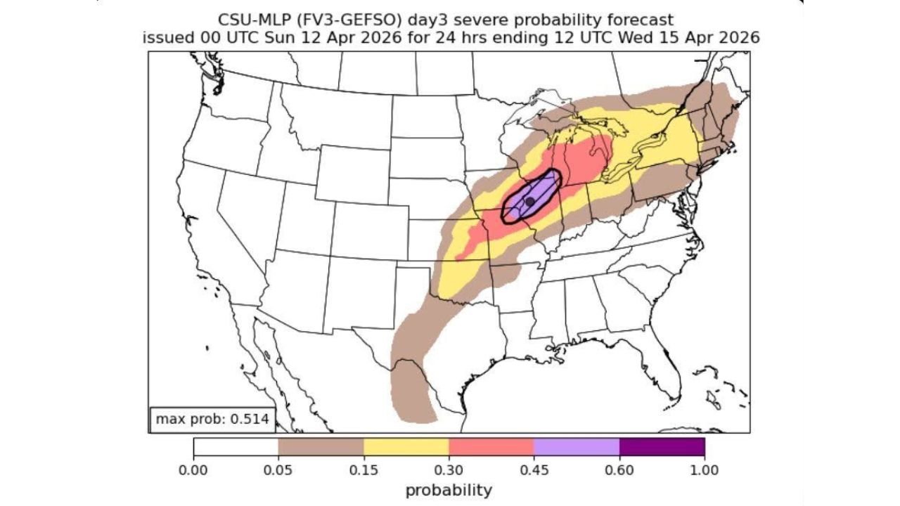
CHICAGO, Illinois — A potentially high-end and all-hazards severe weather day is locking in for Tuesday, April 14 across northwest Illinois and eastern/northeast Iowa — with a severe weather probability forecast reaching a striking 51.4% maximum probability in the core threat zone, damaging winds of 60 to 75+ mph, 2 inch plus destructive hail, and strong tornadoes all on the table simultaneously for communities from Rockford, Illinois through Dubuque and Waterloo, Iowa during the Tuesday afternoon and evening hours.
The setup is being described as a high-end severe weather day if storms can fully develop — especially along and just south of the warm front across the northwest Illinois and northeast Iowa corridor — a region where past setups with this identical atmospheric configuration have produced large hail, damaging winds, and tornadoes with supercells tracking along warm front boundaries.
The 51% Probability Zone — What It Means
The Day 3 severe probability forecast issued for the 24-hour period ending Wednesday, April 15 at 12 UTC shows a dramatically escalating risk structure centered directly on the Illinois-Iowa border region:
- 51.4% maximum probability — Purple Core: The absolute bullseye of Tuesday’s severe weather threat is concentrated in a tight zone centered on the northwest Illinois and northeast Iowa corridor — meaning there is better than a 1-in-2 chance of severe weather occurring within 25 miles of any point in this zone. A 51% severe probability at Day 3 is an extraordinary and rare signal
- 45%+ probability — Pink zone: Expanding outward from the purple core across a broader corridor covering northwest Illinois, northeast Iowa, and adjacent areas
- 30%+ probability — Red zone: Covering a wide swath of Illinois, Indiana, Michigan, and Ohio into the Great Lakes region
- 15%+ probability — Yellow zone: Stretching from the Southern Plains through the entire Midwest and into the Northeast — showing how broad Tuesday’s severe weather footprint truly is
- 5%+ probability — Brown outer zone: Reaching from Texas and Oklahoma all the way through New England — confirming Tuesday as a nationally significant severe weather day
All Four Hazards Simultaneously on the Table
Tuesday’s northwest Illinois and northeast Iowa setup is not threatening one type of severe weather — it is threatening all of them at once:
Strong Tornadoes — If Storms Stay Discrete: The tornado threat for Tuesday is explicitly tied to storm mode — if storms develop as individual, discrete supercells rather than merging into a squall line, the tornado potential increases dramatically. Supercells developing along and just south of the warm front in northwest Illinois and northeast Iowa will immediately tap into elevated low-level helicity near the frontal boundary — the same atmospheric spin mechanism responsible for the most violent and long-track tornadoes in Midwest severe weather history. Past setups with this configuration across this specific region have produced significant tornadoes, and Tuesday’s atmosphere has the ingredients to repeat that history.
Very Large Hail — 2 Inches Plus: The hail threat for Tuesday is described as possibly 2 inches or greater — reaching the destructive range that shatters windshields, strips roofing materials, and can cause serious injury to anyone caught outdoors. The combination of deep moisture, high instability, and strong updraft support in Tuesday’s atmosphere across northwest Illinois and northeast Iowa creates ideal conditions for large hailstone growth within any supercell that develops.
Damaging Winds — 60 to 75+ mph: Wind gusts of 60 to 75 miles per hour and higher are possible with Tuesday’s storms — wind speeds in this range are capable of downing large trees, snapping utility poles, destroying outbuildings, and making travel immediately dangerous. If storms consolidate into a squall line rather than remaining discrete, the wind threat increases while the tornado threat decreases — but damaging winds are present regardless of storm mode.
Intense Supercells Near Boundaries: The warm front slicing through northwest Illinois and northeast Iowa is the primary storm initiation boundary for Tuesday. Supercells that develop near this boundary will have access to the richest moisture, the strongest wind shear, and the most concentrated atmospheric spin available in Tuesday’s setup — making boundary-hugging supercells the most dangerous individual storm type to watch for during the Tuesday afternoon and evening window.
Why Northwest Illinois and Northeast Iowa Are the Bullseye
The 51.4% maximum severe probability sitting directly over the northwest Illinois and northeast Iowa corridor is not arbitrary. This region sits at the precise intersection of three critical atmospheric factors for Tuesday:
Warm, moist Gulf air surging northward into Illinois and Iowa from the south — carrying the deep moisture and surface instability that fuels explosive thunderstorm development. The warm front boundary that serves as the triggering mechanism for Tuesday’s storms is forecast to stall across this exact corridor, meaning the region gets the maximum benefit of both the warm sector moisture to the south and the frontal lifting mechanism along the boundary itself.
Strong wind shear from a powerful storm system lifting into the Midwest provides the organizational support that turns ordinary thunderstorms into long-lived, rotating supercells. The combination of warm moist Gulf air below and strong wind shear aloft is described explicitly as a classic combo for severe storms — the same setup that has produced historic severe weather outbreaks across Illinois and Iowa in previous spring seasons.
Timing — Tuesday’s peak storm development is expected during the afternoon and evening hours, coinciding with maximum surface heating and instability. This timing window gives storms the best possible combination of fuel and forcing to develop, organize, and sustain severe weather production for extended periods.
Communities That Must Be on High Alert Tuesday
- Illinois: Rockford, Galena, Freeport, Sterling, Dixon, and the broader northwest Illinois corridor sit inside or adjacent to the purple and pink probability zones
- Iowa: Dubuque, Waterloo, Cedar Rapids, Iowa City, and the eastern/northeast Iowa corridor are directly within Tuesday’s highest threat area
- Wisconsin: The southern Wisconsin border communities near the Illinois state line fall within the expanding severe weather threat zone
- Indiana and Michigan: The broader 30%+ probability zone extends across Indiana and Michigan — Fort Wayne, South Bend, Grand Rapids, and Lansing are all within meaningful severe weather probability Tuesday
- Ohio: Cleveland, Columbus, and the broader Ohio corridor fall within the yellow 15%+ probability zone as the severe weather footprint expands east
Three Variables That Will Determine How Bad Tuesday Gets
Warm Front Placement — The Prime Tornado Zone: Exactly where the warm front stalls Tuesday afternoon determines which specific communities face the greatest tornado threat. Communities along and just south of the frontal boundary are in the prime tornado zone — and the front’s exact position will sharpen considerably through Monday and Tuesday morning forecasts.
Storm Mode — Discrete vs. Line: If storms develop as discrete supercells, the tornado and large hail threats maximize. If storms consolidate into a squall line, damaging winds become the primary hazard. This is the single most important forecast uncertainty for Tuesday and will be resolved as storm initiation begins Tuesday afternoon.
Timing — Afternoon and Evening Peak: The afternoon and evening hours represent peak intensity for Tuesday’s storms. Communities in northwest Illinois and northeast Iowa should treat the window from 3 PM through midnight as the primary danger period — with the exact timing of storm development depending on how quickly the warm front lifts and instability builds through the day.
What Northwest Illinois and Northeast Iowa Residents Must Do Now
- Residents across Rockford, Freeport, Dubuque, Waterloo, and Cedar Rapids are in the highest probability zone — shelter plans must be confirmed and weather alerts active before Tuesday afternoon arrives
- A 51% severe probability at this forecast range is one of the highest values seen for any single location in recent memory — treat this with the same urgency as a formal Moderate Risk or High Risk designation from the SPC
- All vehicles in northwest Illinois and northeast Iowa should be under cover before Tuesday afternoon — 2 inch plus hail will cause catastrophic damage to any unprotected vehicle
- If discrete supercells develop along the warm front, tornado warnings could come with very short lead times — know your shelter location now, not when the warning is issued
- Monitor NWS Chicago and NWS Quad Cities forecast offices for watch and warning issuance Tuesday — watches covering northwest Illinois and northeast Iowa are likely as storm initiation approaches
- The 60 to 75+ mph wind potential means outdoor structures, signage, and unsecured items need to be secured before Tuesday morning across the entire threat corridor
Tuesday is shaping up as a high-end, all-hazards severe weather day across northwest Illinois and northeast Iowa — and a 51% severe probability sitting over this corridor at Day 3 is a signal that demands immediate preparation and sustained attention from every resident in the risk zone.
WaldronNews.com will continue tracking Tuesday’s all-hazards severe weather threat across northwest Illinois, northeast Iowa, Indiana, Michigan, and Ohio and will provide updates as storm mode, warm front placement, and timing details become clearer heading into the event.