
Special Weather Statement Issued for Green Bay, Appleton and Oshkosh Wisconsin Until 11:30 PM as 30 mph Winds and Half Inch Hail Move Through Tonight
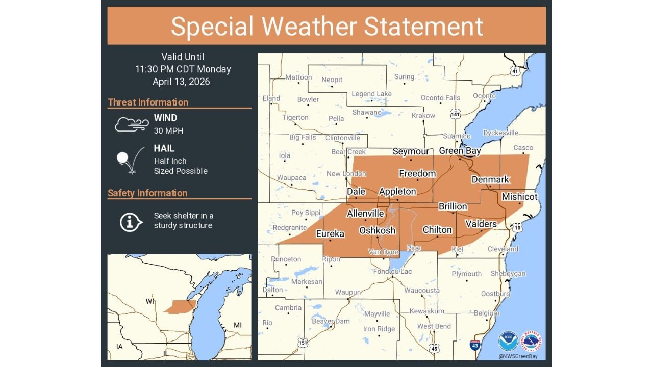
GREEN BAY, Wisconsin — A Special Weather Statement is in effect for Green Bay, Appleton, and Oshkosh, Wisconsin until 11:30 PM CDT Monday, April 13, 2026, as a storm system pushes through the Fox Valley and eastern Wisconsin corridor bringing 30 mph winds and the potential for half-inch sized hail across a broad zone covering communities from Oshkosh and Eureka in the south through Green Bay, Freedom, Denmark, and Mishicot along the Lake Michigan shoreline.
A Special Weather Statement sits one level below a Severe Thunderstorm Warning — it means conditions are hazardous enough to warrant public notification and shelter-seeking behavior, even though the storm has not yet reached full severe criteria. Residents across the warned zone should still take this seriously and seek shelter in a sturdy structure until the statement expires.
Communities Covered by This Statement
The orange-shaded zone covers a significant swath of eastern Wisconsin including:
- Green Bay corridor: Green Bay, Seymour, Freedom, Denmark, Mishicot, Dyckesville, Casco, and Suamico
- Fox Valley corridor: Appleton, Dale, New London, Clintonville, Bear Creek, and surrounding communities
- Oshkosh corridor: Oshkosh, Allenville, Eureka, Van Dyne, Pipe, and Chilton
- Eastern Wisconsin lakeshore: Brillion, Valders, Kiel, and communities along the Lake Michigan corridor
- Winnebago County and surrounding areas: communities between Oshkosh and Appleton including Fond du Lac County border communities
What the Statement Means for You Tonight
30 mph Winds — While not at the severe thunderstorm threshold of 58 mph, sustained winds and gusts reaching 30 mph moving through the Green Bay, Appleton, and Oshkosh corridor tonight are strong enough to knock down small branches, scatter unsecured outdoor items, and create briefly dangerous conditions for anyone caught outside during the storm passage. Driving conditions may also deteriorate temporarily as heavy rain and gusty winds combine to reduce visibility.
Half-Inch Hail — Half-inch hail — roughly the size of a marble — is the threshold at which hail begins to cause minor damage and significant discomfort for anyone caught outdoors without cover. While this size is below the severe threshold of one inch, repeated impacts from half-inch hailstones during a concentrated hail shaft can cause surface damage to vehicles, patio furniture, gardens, and early-season crops. Residents across Green Bay, Appleton, Oshkosh, and Brillion should move vehicles under cover if possible before the storm arrives.
Seek Shelter in a Sturdy Structure — The official safety guidance issued with this statement is explicit — seek shelter in a sturdy structure. This means moving indoors away from windows and staying inside until the statement expires at 11:30 PM CDT.
Why Eastern Wisconsin Is Seeing This Activity Tonight
Monday’s storm pattern across the Upper Midwest has been producing a progressive line of severe and near-severe weather pushing eastward through Minnesota and Wisconsin throughout the evening hours. The Fox Valley corridor — running through Appleton and Oshkosh — and the Green Bay metro sit directly in the path of this eastward-moving storm activity, which is tapping into the atmospheric moisture and instability that has been fueling Monday’s broader severe weather outbreak across the region.
The Lake Michigan shoreline communities from Green Bay south through Mishicot, Denmark, Brillion, and Valders are in a particularly active zone tonight as the storm system interacts with the lake boundary, which can locally enhance wind and precipitation intensity as storms track toward the shoreline.
What to Do Before 11:30 PM CDT
- Move indoors to a sturdy structure now if you are in Green Bay, Appleton, Oshkosh, or any of the listed communities — do not wait for conditions to worsen before seeking shelter
- Secure loose outdoor items — 30 mph winds can scatter patio furniture, decorations, garbage cans, and other unsecured objects across yards and into roadways
- Move vehicles under cover if you can do so quickly and safely — half-inch hail falling in a concentrated shaft can leave surface marks on vehicle paint and glass
- Avoid unnecessary driving through the warned zone until after 11:30 PM CDT when the statement expires — reduced visibility and gusty winds make road conditions briefly hazardous
- The storm passage should be relatively quick — stay sheltered until 11:30 PM and conditions should improve shortly after
Conditions across Green Bay, Appleton, and Oshkosh are hazardous tonight. Stay indoors, keep weather alerts active, and wait for the all-clear after 11:30 PM CDT.
WaldronNews.com will continue tracking storm activity across Wisconsin tonight and will provide updates as conditions evolve across the Green Bay, Appleton, and Oshkosh corridor.