
Severe Thunderstorm Watch Issued for Lower Michigan Until 5 AM as Dangerous Storm Line Pushes Through Traverse City, Muskegon, Grand Rapids and Flint Overnight
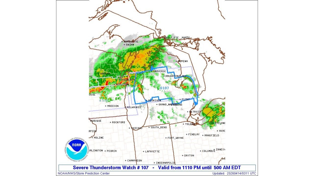
GRAND RAPIDS, Michigan — A Severe Thunderstorm Watch is now in effect across lower Michigan from 11:10 PM Monday through 5:00 AM EDT Tuesday, April 14, 2026, as a powerful and fast-moving storm system pushes eastward through the Great Lakes region — threatening communities across a wide zone covering Traverse City, Muskegon, Grand Rapids, Flint, and the broader lower Michigan peninsula with dangerous overnight severe thunderstorm conditions.
The watch zone — outlined in blue on the radar — covers a significant portion of lower Michigan as an active line of intense storms with deep red and orange radar cores is already pushing through Green Bay and Appleton, Wisconsin and tracking directly toward Michigan’s western shoreline communities. This is an overnight severe weather event — the most dangerous type — when millions of residents will be asleep and less likely to hear or respond to warnings without active alert systems.
Communities Inside the Severe Thunderstorm Watch
The watch box covers a broad zone across lower Michigan including:
- Northwest Lower Michigan: Traverse City, Houghton Lake, and the northern lower peninsula corridor
- West Michigan: Muskegon and the Lake Michigan shoreline communities
- Central Michigan: Grand Rapids and surrounding Kent County communities
- East Central Michigan: Flint and the broader mid-Michigan corridor
- Upper Peninsula fringe: Marquette and Gwinn sit just north of the primary watch zone on active radar
What Is Already on Radar Right Now
The live radar at 10:12 PM CDT shows a well-organized and intense storm line already fully active and pushing east through Wisconsin — with deep red and orange cores visible near Green Bay, Appleton, and Wausau indicating the most intense storm activity. This line is tracking directly toward Michigan’s western shoreline and will arrive across Muskegon and Grand Rapids during the watch period.
The storm system producing tonight’s watch is the same large-scale pattern that has been driving Monday’s severe weather outbreak across the Upper Midwest — and the radar confirms that this is not a weakening system. The storm line is organized, intense, and moving with purpose toward lower Michigan.
Why an Overnight Severe Thunderstorm Watch Is Especially Dangerous
A Severe Thunderstorm Watch issued from 11:10 PM to 5:00 AM covers the heart of overnight sleeping hours for millions of Michigan residents. Overnight severe weather events are statistically more dangerous than daytime events for several reasons:
Residents who are asleep when storms arrive may not hear outdoor warning sirens even if they live close to one. Phone emergency alerts set to Do Not Disturb mode will not sound unless specifically configured to override that setting. Visual confirmation of approaching storms is impossible in darkness, removing one of the natural warning signals people rely on during daytime severe weather.
For communities like Traverse City, Grand Rapids, Muskegon, and Flint — where tonight’s most intense storm activity is expected — the overnight timing means the window between a warning being issued and a storm arriving may be measured in minutes, not the extended lead time that daytime severe weather events often provide.
Immediate Actions for Lower Michigan Residents Tonight
- Set your phone weather alerts to override Do Not Disturb right now — this is the single most important action every resident in Traverse City, Muskegon, Grand Rapids, and Flint can take before going to sleep tonight
- Know your shelter location before you go to bed — identify the lowest interior room in your home away from windows so you are not searching for it in the dark if a warning wakes you
- If you are still awake — stay awake and monitor conditions until the storm line clears your area — do not go to sleep during an active Severe Thunderstorm Watch if storms are imminent in your community
- Do not go outside to assess storm conditions during the overnight hours — downed power lines in darkness are invisible and immediately lethal
- The watch runs until 5:00 AM EDT — keep alerts active through the entire overnight period as storms may arrive at different times across the large watch zone
- Residents near Traverse City and Houghton Lake in the northern lower peninsula should note they are in the watch zone and should monitor conditions closely as the storm line pushes north and east through the night
The Broader Storm Picture
Tonight’s severe thunderstorm watch for lower Michigan is the eastern edge of a storm system that has been producing severe weather across Minnesota and Wisconsin throughout Monday evening. The same line that produced severe thunderstorm warnings near Green Bay and Appleton earlier tonight is now tracking into Michigan — and the active radar confirms it has maintained its intensity during that eastward track.
The storm line will push through western Michigan communities first — including Muskegon and Grand Rapids — before tracking northeast toward Traverse City and Flint through the overnight hours. Timing of storm arrival will vary by location, but all communities inside the watch box should treat the entire overnight period as an active threat window.
What Happens After 5 AM
The Severe Thunderstorm Watch expires at 5:00 AM EDT Tuesday, April 14 — at which point the storm system should have pushed through most of lower Michigan and conditions should begin to improve across the region. However, residual storm activity and gusty winds may linger into early Tuesday morning for some communities on the eastern edge of the watch zone near Flint and the mid-Michigan corridor.
Residents across lower Michigan are urged to get their alert systems configured tonight, know their shelter plan, and take any warnings issued during the overnight hours with immediate and serious action.
WaldronNews.com will continue tracking overnight severe weather across lower Michigan and will provide updates as warnings are issued across Traverse City, Muskegon, Grand Rapids, and Flint through the 5 AM EDT expiration of tonight’s watch.