
Illinois, Missouri and Indiana See Up to 4.18 Inches of Rain in 24 Hours With Standing Water Across Central Indiana Fields Including St. Louis, Effingham, Indianapolis and Bloomington
ST. LOUIS, Missouri – Observed 24 hour rainfall totals as of 8:00 PM Monday, May 18 are revealing a dramatic flooding picture across Illinois, Missouri and Indiana, with localized totals reaching 4.18 inches south of Effingham, Illinois and several inches of standing water reported across fields throughout central Indiana. The rainfall corridor stretches from Jefferson City and Columbia, Missouri northeast through St. Louis, Alton, Springfield, Decatur, Effingham and all the way through Indianapolis and Bloomington, Indiana.
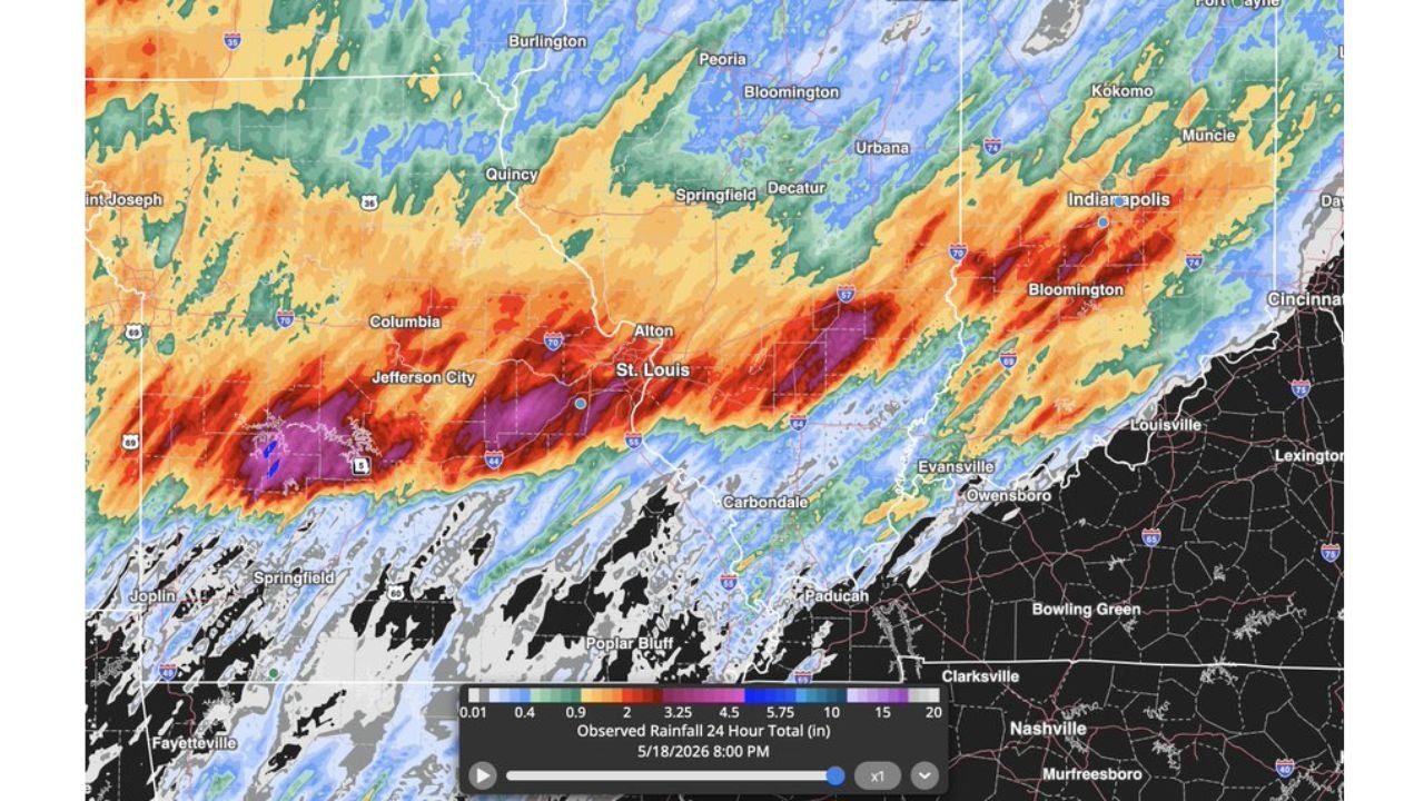
Where the Heaviest Rain Fell Monday May 18
The observed 24 hour rainfall map ending at 8:00 PM Monday, May 18 tells the flooding story clearly across the region.
| Location | 24 Hour Rainfall Total |
|---|---|
| South of Effingham, Illinois | 4.18 inches confirmed |
| Effingham to Flora, Illinois corridor | 3.25 to 4.5 inches |
| Altamont and Saint Elmo, Illinois | 2 to 3.25 inches |
| Newton and Olney, Illinois | 1 to 2 inches |
| St. Louis and Alton, Missouri and Illinois | 4.5 to 5.75 inches in localized areas |
| Jefferson City and Columbia, Missouri | 3.25 to 5.75 inches |
| Indianapolis and Bloomington, Indiana | 3.25 to 4.5 inches |
| Springfield and Decatur, Illinois | 2 to 4 inches |
| Carbondale and Paducah area | 1 to 2 inches |
Standing Water Across Central Indiana Fields
Several fields across central Indiana are reporting multiple inches of standing water as of Monday evening, May 18. The rainfall corridor impacting Indianapolis and Bloomington dropped enough rain in 24 hours to overwhelm field drainage across the region, leaving agriculture across central Indiana sitting under water tonight. Conditions south of Effingham, Illinois are described as particularly severe given the 4.18 inch localized total confirmed in that area.
The Wider Rainfall Corridor Missouri to Indiana
The 24 hour rainfall map shows a distinct northeast-to-southwest oriented rainfall band stretching from Jefferson City and Columbia, Missouri all the way through St. Louis, Alton, Springfield, Quincy, Decatur, Effingham, Flora, Indianapolis and Bloomington. This band reflects the path of the severe storm complex that moved through the region throughout Monday, May 18. Communities along Interstate 70 from St. Louis east through Indianapolis saw some of the heaviest rainfall totals in the entire corridor during this 24 hour period.
Road and Field Flooding Concerns Tonight
With 4.18 inches falling south of Effingham and 4.5 to 5.75 inch totals concentrated near St. Louis and Jefferson City in just 24 hours, road flooding remains an active concern across Illinois, Missouri and Indiana tonight. Low-lying roads, underpasses and creek crossings across central Indiana and southern Illinois should be avoided until water levels recede. Turn around and do not drive through any flooded roadway. Six inches of moving water can knock a person down and twelve inches can sweep a vehicle away.
WaldronNews.com will continue tracking these 24 hour rainfall totals and flooding impacts across Illinois, Missouri and Indiana and will provide updates as flood reports and road closures develop through Monday night, May 18.