
70 mph Wind Gusts, 2 Inch Hail and Tornadoes Targeting Nebraska, Kansas and Iowa Including Omaha, Lincoln, Sioux Falls and Topeka With Additional Storms Developing Through 7 PM CT
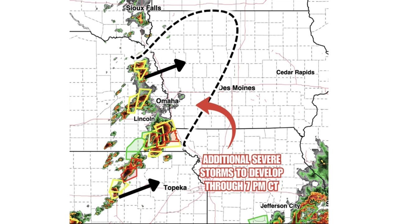
OMAHA, Nebraska – A new round of severe storms is developing across the Central Plains as of 4:19 PM CT Monday, May 18, with additional severe storms expected to expand into western Iowa through 7:00 PM CT. Every storm in this complex is capable of producing 70 mph or higher wind gusts, 2 inch or larger hail and several tornadoes across Nebraska, Kansas and Iowa.
What Is Happening Right Now at 4:19 PM CT
The current radar at 4:19 PM CT shows an active storm complex stretching from near Sioux Falls, South Dakota south through Omaha, Lincoln and Topeka, Kansas, with multiple severe thunderstorm and tornado warning boxes already active across this corridor. Additional severe storms are expected to fire and expand coverage into western Iowa including toward Des Moines through 7:00 PM CT tonight.
Every Storm Carries Three Major Threats
| Threat | Severity |
|---|---|
| Wind Gusts | 70 mph or higher |
| Hail Diameter | 2 inches or larger |
| Tornado Threat | Several tornadoes possible |
All three threats are active with every storm in this complex from Sioux Falls south through Topeka right now. There is no weak storm in this cluster.
Cities Under the Gun Through 7 PM CT
Sioux Falls, South Dakota sits on the northern end of the active storm complex and faces 70 mph gusts and 2 inch hail through this evening. Omaha and Lincoln, Nebraska are directly within the active warning corridor as of 4:19 PM CT with tornado and severe thunderstorm warnings active. Topeka, Kansas sits on the southern end of the complex with additional storm development pushing southeast this evening. Des Moines and Cedar Rapids, Iowa are in the expansion zone where additional severe storms are expected to develop through 7:00 PM CT and should not let their guard down through tonight.
The Window Through 7 PM CT Is Critical
Additional severe storms are specifically forecast to develop through 7:00 PM CT Monday, May 18, meaning the threat is not winding down yet. The storm complex is expected to expand eastward into western Iowa over the next few hours, bringing 70 mph gusts, 2 inch hail and tornado potential to communities that have not yet seen storms today. If you are in western Iowa including toward Des Moines, your window to shelter is right now before storms arrive.
WaldronNews.com will continue tracking these developing severe storms across Nebraska, Kansas and Iowa and will provide updates as tornado warnings, wind reports and storm expansion develop through 7:00 PM CT Monday, May 18.