
Early June Tropical System Possible From Western Caribbean Targeting Florida and Gulf Coast With Above Normal Rainfall Through June 7
MIAMI, Florida – A potential tropical system developing out of the western Caribbean is being watched closely for the first 2 weeks of June, with forecast data showing lower than normal surface pressures and higher to much higher than normal rainfall across the Gulf, Florida and Bahamas areas through Sunday, June 7, 2026. A slow-moving tropical system without significant wind and surge could actually benefit Florida’s ongoing drought if it materializes.
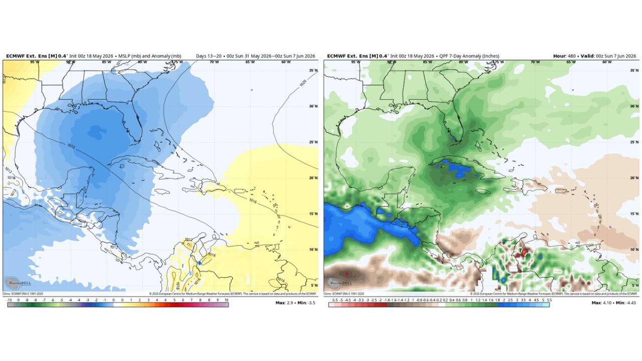
What the Data Is Showing for Early June
Long range forecast data valid from Sunday, May 31 through Sunday, June 7, 2026 is painting a consistent signal across the Gulf and Florida region:
- Lower than normal surface pressures are showing across the entire Gulf of Mexico, Florida and Bahamas region during the May 31 through June 7 window, a pattern associated with increased tropical development potential out of the western Caribbean.
- Higher to much higher than normal rainfall anomalies are indicated across the Gulf, Florida and Bahamas areas through Sunday, June 7, with above normal precipitation showing across Florida and deep into the Gulf region.
- The pressure anomaly map shows the most significant below-normal pressure signal centered directly over the Gulf of Mexico and Florida, with values running 2 to 8 millibars below the historical average for this time of year.
Why Early June Systems Are Typically Weaker
June tropical systems emerging from the western Caribbean are generally slow moving or weak compared to peak season storms:
- A slow-moving system without significant wind and storm surge would deliver much-needed rainfall to Florida, which is currently dealing with a significant ongoing drought.
- June systems historically lack the deep warm water fuel that powers the destructive hurricanes of August and September.
- The data does not guarantee a named tropical storm will develop. It shows an environment favorable for tropical activity and well above normal rainfall across the Gulf and Florida through June 7.
Above Normal Rainfall Anomaly Through June 7
The 7 day rainfall anomaly map valid through Sunday, June 7, 2026 shows:
- Florida sits within a zone of above normal rainfall through June 7, with the signal strongest across southern and central Florida where drought conditions have been most severe.
- The Gulf of Mexico shows a broad area of above normal to well above normal rainfall through June 7, consistent with the lower pressure and increased moisture signal on the pressure map.
- The Bahamas and Cuba area also show above normal rainfall through June 7 as the tropical moisture signal extends across the broader Caribbean basin.
What Florida Residents Should Watch For
This is not an immediate threat requiring action today. However, Florida residents from the Gulf Coast through South Florida should begin monitoring tropical weather updates as June approaches. Even a weak slow-moving tropical system can produce dangerous flooding, particularly over drought-hardened ground that cannot absorb heavy rain quickly. Begin checking tropical forecasts daily as we move into the final week of May and the first week of June.
WaldronNews.com will continue tracking this potential early June tropical system across Florida and the Gulf Coast and will provide updates as development chances and rainfall totals through Sunday, June 7 become clearer.