
Kansas and Nebraska Tornado Threat Continues Monday May 18 Evening Near Concordia, Beatrice and Manhattan as Window Closes
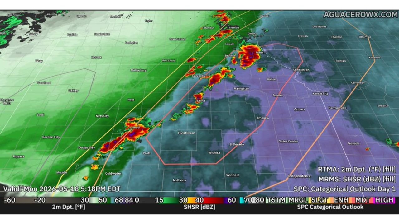
CONCORDIA, Kansas – As of 5:18 PM EDT Monday, May 18, storms across Kansas and Nebraska are struggling to fully organize into discrete supercells, but the threat of strong to intense tornadoes continues as long as any storm can break free along the line pushing through Concordia, Beatrice and Manhattan. The window is closing but has not yet shut.
What Is Happening Right Now
Storms are firing along a line from Lamar and Dodge City, Kansas northeast through Concordia, Red Cloud and Beatrice, Nebraska as of 5:18 PM EDT. Two factors are working against full supercell development right now:
- Stable air left behind from an earlier morning storm complex is limiting how explosively new storms can develop this afternoon.
- Storms are crossing the atmospheric boundary rather than latching onto it, preventing them from reaching their full severe weather potential this evening.
The Tornado Threat Is Not Over
If any storm along the line from Lamar and Dodge City through Concordia, Beatrice and Manhattan can break free and remain organized for even a short period, strong to intense tornadoes remain possible this evening. Residents across Concordia, Beatrice, Manhattan, Hutchinson, Topeka and Kansas City must stay weather-alert and sheltered until all warnings expire tonight.
Cities Still in the Active Threat Zone
- Beatrice and Auburn, Nebraska carry the most intense radar returns as of 5:18 PM and face the most immediate tornado threat right now.
- Concordia and Red Cloud, Kansas and Nebraska sit along the active storm line and face continued severe weather risk this evening.
- Manhattan, Topeka, Emporia and Hutchinson, Kansas remain within the active outlook zone through Monday evening, May 18.
- Lamar and Dodge City, Kansas have active cells pushing northeast and should remain alert through early evening.
- Kansas City, Saint Joseph and Harrisonville, Missouri are on the eastern edge of the threat zone for Monday evening.
Stay Alert Through Tonight
Even underperforming storms in this environment can still produce damaging winds, large hail and brief tornadoes. A single storm breaking free for even 30 to 60 minutes has enough fuel to produce a strong to intense tornado. Do not drop your guard before all warnings have expired for your area tonight.
WaldronNews.com will continue tracking this tornado threat across Kansas and Nebraska and will provide updates as storm organization and tornado warnings develop through Monday evening, May 18.