
Washington D.C. Could Hit 90 Degrees Three Days in a Row This Week in a Heat Event That Would Be Second Earliest on Record Dating Back to 1929
WASHINGTON, D.C. — The nation’s capital is heading into one of the most extraordinary and historically significant heat events ever recorded for mid-April, as temperatures across Washington D.C. and the surrounding region are forecast to reach near or above 90 degrees for several consecutive days this week — readings that are more than a month ahead of schedule and threatening to shatter records that have stood for decades across the D.C. metro, Virginia, and Maryland corridor.
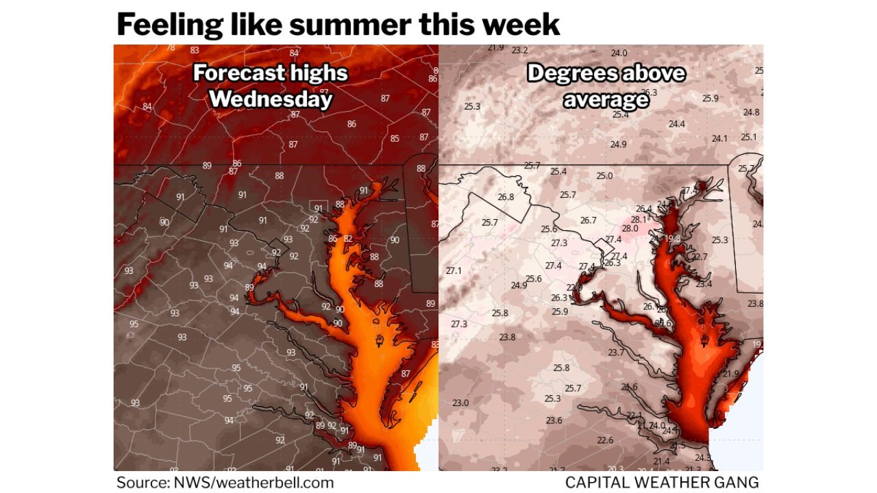
Forecast highs of 89°F Tuesday, 93°F Wednesday, and 92°F Thursday are being projected for Washington D.C. — and if all three days reach 90 degrees or above, it would mark only the second earliest three-consecutive-90-degree stretch on record, behind only a remarkable heat event that occurred April 6 through 8, 1929 — nearly a century ago.
How Hot It Will Get — Day by Day
The heat builds through the week across Washington D.C. and the Dulles International Airport corridor:
- Tuesday, April 14: Forecast high of 89°F in D.C. — threatening the standing record of 91°F set in 1960. Dulles airport record for Tuesday stands at 87°F (1960)
- Wednesday, April 15: Forecast high of 93°F in D.C. — threatening the standing record of 89°F set in 1941, which if reached would shatter the Wednesday record by 4 degrees. Dulles record is 87°F (1967)
- Thursday, April 16: Forecast high of 92°F in D.C. — threatening the standing record of 92°F set in 2002. Dulles record stands at 91°F (2002)
Wednesday’s forecast is the most alarming from a record-breaking perspective — a high of 93°F would obliterate a record that has stood since 1941, making it one of the most significant single-day April temperature records ever broken at the D.C. station.
Why This Heat Is So Historically Unusual
Context makes this week’s heat event even more remarkable. The average first 90-degree day in Washington D.C. is May 18 — meaning the city typically has to wait until late spring before hitting the 90-degree threshold. This week’s forecast puts D.C. at or above 90 degrees in mid-April — more than five weeks ahead of the historical average.
For Dulles International Airport, the average first 90-degree day is May 20 — and the earliest 90 ever recorded at Dulles was April 6, 2010. This week’s forecast temperatures would place Dulles in truly historic territory.
The D.C. station’s earliest 90-degree day on record is March 22, 1907 — a remarkably early reading that has stood for over a century. While this week does not challenge that all-time earliest date, the prospect of three consecutive 90-degree days in mid-April is an extraordinarily rare occurrence by any historical measure.
The last time Washington D.C. recorded three consecutive 90-degree days this early in April was April 16 through 18, 2002 — an event that itself was considered exceptional. If this week’s forecast verifies, it would push that record back even earlier in the calendar, to April 14 through 16, 2026.
What 25 to 28 Degrees Above Average Means for the Region
The temperature anomaly map tells the full story of how extreme this heat event truly is. Temperatures across Washington D.C., Maryland, and northern Virginia are running 25 to 28 degrees above the historical average for mid-April — shown in the deep red and orange shading concentrated directly over the Chesapeake Bay corridor and the D.C. metro area.
A 25 to 28 degree above-average anomaly is not a warm spell — it is an atmospheric event of exceptional magnitude. For comparison, a typical warm April day might run 5 to 10 degrees above normal. Running nearly 30 degrees above normal in mid-April represents a heat dome scenario that belongs in July or August, not the second week of April.
Wednesday’s forecast high of 93°F across the D.C. corridor — shown in the deep orange heat core on the Wednesday forecast map — places the region firmly in dangerous heat territory for mid-April, when most residents and infrastructure are not physically or operationally prepared for summer-intensity temperatures.
Health and Safety Concerns Across D.C., Maryland and Virginia
The combination of temperatures 25 to 28 degrees above normal arriving in mid-April — before most people have physiologically acclimatized to summer heat — creates genuine public health risks across the Washington D.C., Maryland, and Virginia region:
Heat illness risk is elevated for outdoor workers, elderly residents, young children, and anyone without access to air conditioning. The human body acclimates to heat gradually over the spring and summer season — mid-April heat at 93°F arrives before that acclimatization process has begun, making even healthy individuals more susceptible to heat exhaustion and heat stroke than they would be during the same temperatures in July.
Cooling centers and air conditioning are the most important resources this week for vulnerable residents across the D.C. metro. Anyone without reliable home cooling should identify their nearest public cooling center before Tuesday’s heat begins building.
Outdoor activities including yard work, construction, athletic events, and any extended outdoor exposure during peak afternoon hours — roughly noon through 6 PM — should be approached with extreme caution Tuesday through Thursday across the entire region.
Multi-Day Heat Pattern
The heat pattern is not a single-day event — it is a multi-day heat siege that builds through Tuesday and peaks on Wednesday and Thursday before any meaningful relief arrives. The Wednesday forecast high of 93°F represents the apex of the event for Washington D.C., and with overnight lows also running well above normal, the region will have limited overnight recovery time between each successive hot day.
Any relief from this extraordinary heat pattern is not expected until Friday at the earliest — meaning residents across D.C., Maryland, and Virginia face a sustained three-day period of potentially record-breaking heat with no midweek break.
What to Watch and How to Stay Safe
- Wednesday is the most dangerous day — a forecast high of 93°F threatening a record set in 1941 makes Wednesday the peak heat day of the entire event across Washington D.C.
- Check on elderly neighbors and family members who may not have air conditioning or may not recognize signs of heat illness — the mid-April timing means many vulnerable residents are not yet in summer heat safety routines
- Limit outdoor activity between noon and 6 PM Tuesday through Thursday — this is the peak heat window each day when temperatures will be at or near their daily maximum
- Stay hydrated aggressively — drink water before you feel thirsty during heat events of this magnitude, as thirst is a late indicator of dehydration in extreme heat
- Watch for record high temperature announcements from official weather stations across D.C. and Dulles — if Wednesday’s 93°F forecast verifies, it will be one of the most significant April temperature records broken at the D.C. station in the modern era
- Pet owners across D.C., Maryland, and Virginia should keep animals indoors during peak heat hours and never leave pets in vehicles during this heat event
Washington D.C. is about to experience something that happens perhaps once in a generation — a genuine mid-April heat siege capable of breaking records dating back to 1929 and delivering summer temperatures to a city that is still weeks away from its normal first hot day of the year.
WaldronNews.com will continue tracking this historic heat event across Washington D.C., Maryland, and Virginia and will provide updates as temperature records are approached and potentially broken Tuesday through Thursday.