
Winter Returns to Northern Utah Thursday Night as Cold Storm Drops Snow to Valley Floors Along the Wasatch Front With Up to 11 Inches Possible in Mountains and Friday Morning Commute at Risk
SALT LAKE CITY, Utah — Spring is taking a sharp and sudden detour across northern Utah this week as a strong cold storm system moves in Thursday, bringing a dramatic shift back to winter conditions along the Wasatch Front — with snow levels expected to drop rapidly to the valley floor Thursday afternoon and evening, turning what starts as rain into snow in a hurry and leaving 1 to 3 inches in valley communities with significantly higher totals possible in the mountains and on the benches heading into early Friday morning.
The storm is fast-moving but highly impactful — and its timing could not be more disruptive. The best chance for snowfall accumulation falls squarely across Thursday night into early Friday morning — putting the Friday morning commute directly in the crosshairs of winter-like road conditions across the Salt Lake Valley, Wasatch Back, and surrounding northern Utah communities.
Where Snow Will Fall and How Much
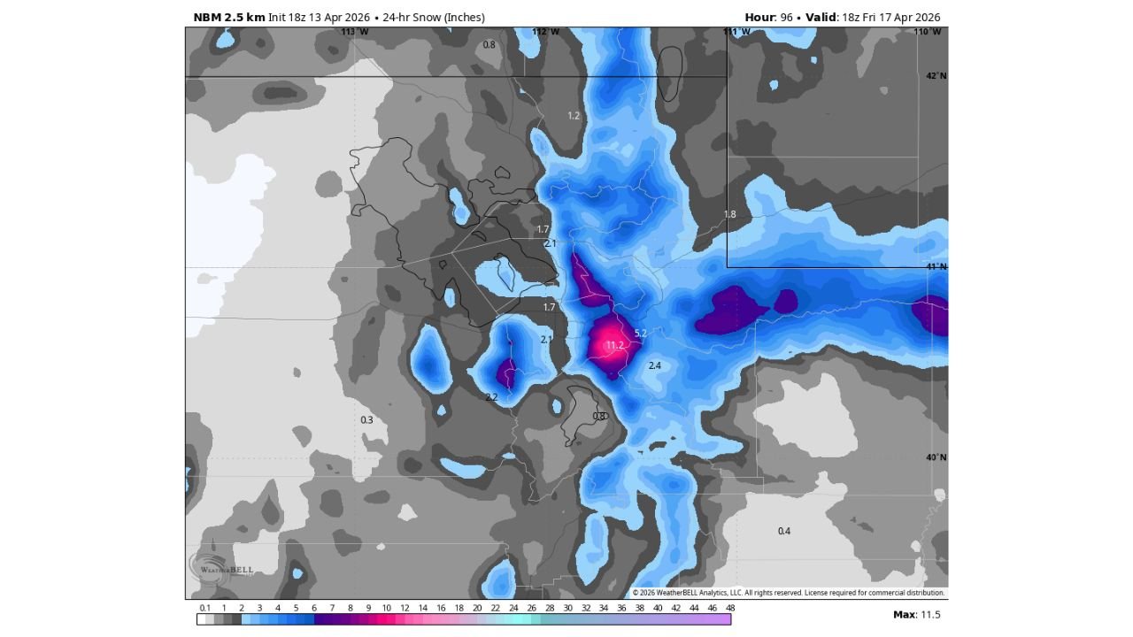
The 24-hour snowfall forecast valid Friday, April 17 paints a clear and striking picture of where the heaviest snow will accumulate:
- Wasatch Mountains — Core Zone: The mountain core shows snowfall totals reaching 11.2 inches in the highest accumulation zone — shown in the deep pink and purple on the snowfall map — with surrounding mountain areas receiving 5.2 to 4.2 inches across a broad elevation band. The mountains will see the most significant snowfall totals from this system
- Wasatch Front Benches and Wasatch Back: 2.1 to 3.2 inches are forecast across the higher bench communities sitting between the valley floor and the mountain base — these elevated residential areas face some of the most treacherous driving conditions during rapid snow events
- Salt Lake Valley Floor: General accumulations of 1 to 3 inches are expected across valley floor communities with locally higher amounts possible depending on lake-enhanced snow development
- Northern Utah broader corridor: Surrounding areas show 1.2 to 2.4 inches across portions of northern Utah extending into the Cache Valley and surrounding regions
- Lake-Enhanced Snow Wildcard: One critical factor that could push totals significantly higher in isolated areas is lake-effect snow enhancement from the Great Salt Lake. If conditions align favorably for lake enhancement, localized snowfall totals could exceed the general forecast by several inches in specific corridors — making exact accumulation amounts difficult to pin down precisely
Why This Storm Is Hitting Hard Despite Being Fast Moving
The speed of this storm system is actually part of what makes it dangerous. A fast-moving cold front pushing through Thursday afternoon and evening will compress the rain-to-snow changeover into a very short window — meaning temperatures and snow levels will drop rapidly rather than gradually. Drivers caught on roads during this transition period will experience conditions shifting from wet rain to heavy snow within minutes, creating some of the most dangerous driving conditions of the season on roads that are not yet fully winter-hardened after weeks of spring temperatures.
The Wasatch Front — the heavily populated urban corridor running through Salt Lake City, Ogden, Provo, and surrounding communities — is particularly vulnerable to this type of rapid winter transition storm. The dramatic elevation changes between the valley floor and the surrounding mountain terrain mean that even modest snowfall totals at the valley level coincide with very heavy mountain snow, creating hazardous conditions simultaneously at all elevation levels.
The Wasatch Back communities — sitting on the eastern side of the Wasatch Range — may see higher accumulations than the primary valley forecast suggests, with the mountain terrain focusing and enhancing snowfall in these areas during the Thursday night accumulation window.
The Friday Morning Commute — What to Expect
The storm’s most impactful timing window is Thursday night into early Friday morning — which directly targets the Friday morning commute across northern Utah. Roads that were wet or slushy during Thursday evening’s rain-to-snow transition will have overnight temperatures to freeze and compact fresh snowfall into slick, icy surfaces by the time commuters head to work and school Friday morning.
Interstate 15, U.S. Highway 89, and mountain canyon roads across northern Utah face the greatest commute impacts Friday morning. Canyon roads leading into and out of the Wasatch Mountains — including Parley’s Canyon, Big Cottonwood Canyon, Little Cottonwood Canyon, and Ogden Canyon — will see the heaviest snowfall totals and could face travel restrictions or closures by Friday morning if mountain accumulations reach the upper end of the forecast range near 11 inches.
Valley floor roads across Salt Lake City, West Valley City, Sandy, and the broader Wasatch Front will face 1 to 3 inches of accumulated snow — enough to create slick travel conditions, reduce traction, and extend commute times significantly on Friday morning for drivers who have already switched to summer tires or who are driving vehicles without adequate winter traction capability.
What Northern Utah Residents Need to Do Before Thursday
- Check your tires — if you have already transitioned to summer tires, Thursday’s storm is a serious concern. Adequate tread and traction on wet and snowy roads is essential for safe Friday morning commuting
- Allow extra travel time Friday morning — snow accumulation Thursday night means Friday’s commute will be slower and more hazardous than a typical spring Friday regardless of where you live along the Wasatch Front
- Mountain canyon travelers should monitor Utah Department of Transportation road condition updates before attempting any canyon travel Friday morning — closures and chain requirements are possible at the upper end of the snowfall forecast
- Bench and Wasatch Back residents — your communities typically see higher accumulations than valley floor totals suggest, and with 2 to 3+ inches possible overnight, Friday morning driveways and neighborhood streets may be significantly snow-covered
- Watch for lake-enhanced snow bands Thursday night — if Great Salt Lake enhancement develops, localized areas could see snowfall rates and totals that significantly exceed the general forecast, particularly in communities downwind of the lake
- Prepare for a fast transition Thursday afternoon — the rain-to-snow changeover will happen quickly as the cold front pushes through. If you are driving Thursday evening, be prepared for conditions to shift from rain to snow within your trip
A spring snowstorm is moving in, and northern Utah’s Wasatch Front communities need to be ready before Thursday evening arrives. The mountains will bear the heaviest burden with up to 11 inches possible, but the valley and bench communities face enough accumulation to make Friday morning’s commute genuinely challenging across the region.
WaldronNews.com will continue tracking this spring snowstorm across northern Utah and will provide updates on accumulation totals, road conditions, and any canyon closures as the storm moves through Thursday night and into Friday morning.