
Multiple Tornado Warnings Active Across Southern Minnesota and Northern Iowa Monday Night With Confirmed Tornado Just Southeast of Spencer Iowa as Storms Pound Mankato, Albert Lea, Fairmont and Mason City
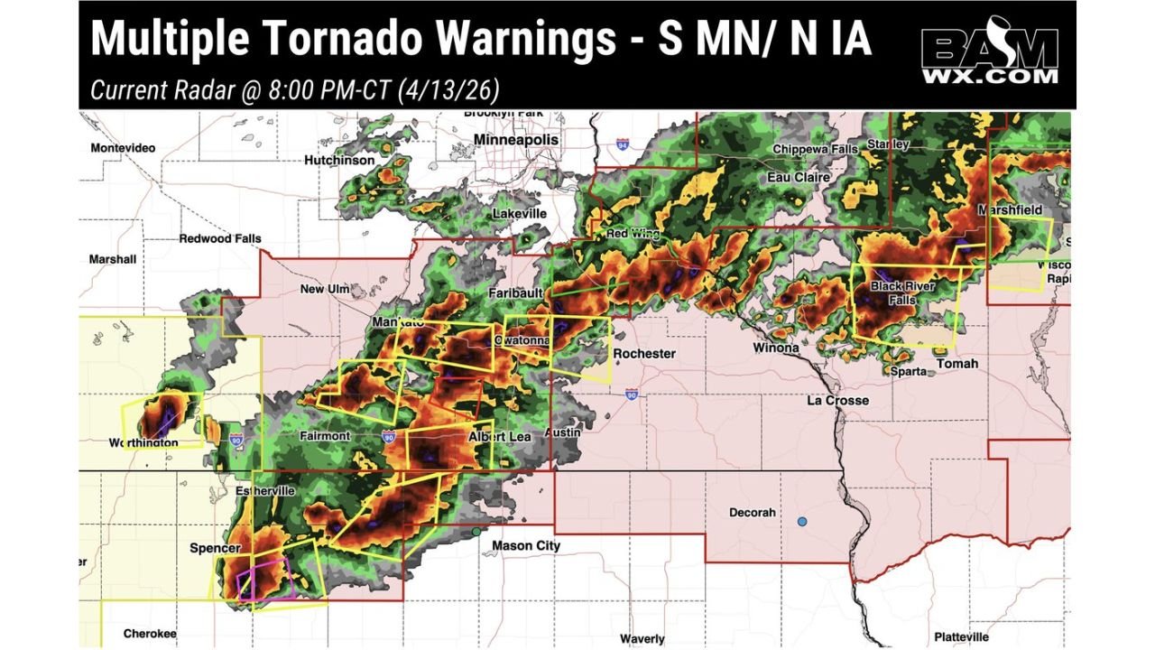
MANKATO, Minnesota — Multiple tornado warnings are active right now across southern Minnesota and northern Iowa as a dangerous and rapidly evolving storm outbreak tears through the region Monday evening — with a confirmed tornado warning indicated in purple on radar located just southeast of Spencer, Iowa as of 8:00 PM CT Monday, April 13, 2026, and additional tornado warnings blanketing communities across Mankato, Owatonna, Albert Lea, Fairmont, Estherville, and Mason City.
These storms are no joke. The radar at 8 PM CT shows an explosive and chaotic severe weather situation unfolding simultaneously across a massive corridor from Worthington and Spencer in northwest Iowa through Mankato, Faribault, Owatonna, and Albert Lea in southern Minnesota and stretching northeast toward Rochester, Winona, and the Wisconsin border — with tornado warning boxes stacked across the entire region in yellow and the confirmed tornado indicator in purple near Spencer demanding immediate action from every resident in the warned zones.
Active Warning Zones Right Now
The live radar at 8:00 PM CT shows tornado warnings covering:
- Iowa — Spencer corridor: A confirmed tornado is on the ground or indicated on radar just southeast of Spencer, Iowa — this is the most immediately dangerous warning on the board right now. Spencer, Estherville, and surrounding northwest Iowa communities need to be sheltered immediately
- Iowa — Northern corridor: Mason City, Waverly, and the broader northern Iowa communities are within the active severe weather zone shown in red on the radar
- Minnesota — South central: Mankato, New Ulm, Owatonna, Faribault, and Fairmont all sit inside active tornado warning boxes as of 8 PM CT
- Minnesota — Albert Lea corridor: Albert Lea and Austin are within the active warning zone as storms push east through southern Minnesota
- Minnesota — Rochester area: Rochester and surrounding Olmsted County communities are in the path of the storm system pushing northeast
- Minnesota — Worthington: Worthington sits on the western edge of the active warning corridor near the Iowa border
- Wisconsin — Western fringe: Winona, La Crosse, Sparta, Tomah, and Black River Falls are in the path of storms pushing east toward the Wisconsin border
The Confirmed Tornado Near Spencer Iowa — Act Now
The purple confirmed tornado warning just southeast of Spencer, Iowa is the most critical and immediately life-threatening situation on tonight’s radar. A confirmed tornado designation means a tornado has been visually confirmed by spotters or detected on radar with a high degree of certainty — this is not a precautionary warning but an active, real, and dangerous tornado event.
Anyone in Spencer, Estherville, Emmetsburg, and surrounding northwest Iowa communities who has not already taken shelter needs to move to the lowest floor interior room of a sturdy building immediately. Do not wait for the tornado to be visible — by the time a tornado is visible at night, you may have seconds, not minutes, to respond.
What the Radar Shows Across the Full Warning Zone
The 8 PM CT radar is alarming in its scope and intensity. Deep red and orange radar cores — indicating the most intense storm activity — are visible across a broad swath from Worthington and Spencer in the southwest through Mankato, Owatonna, Albert Lea, and Faribault in south-central Minnesota, with additional intense cells pushing toward Rochester and the Wisconsin border.
The sheer number of simultaneous tornado warning boxes visible on the radar — spanning the entire southern Minnesota and northern Iowa corridor — confirms that this is not a single-storm event. Multiple organized, rotating supercells are operating simultaneously across this region, each capable of producing additional tornadoes as they continue their northeast track through the evening hours.
The storm system is pushing northeast — meaning communities currently on the western edge of the warning zone will see storms arrive, and communities ahead of the storm line to the northeast — including Rochester, Winona, La Crosse, and the western Wisconsin communities of Sparta, Tomah, and Black River Falls — need to be preparing for storm arrival right now.
Communities That Must Be Sheltered Immediately
Already in active warnings — shelter NOW:
- Spencer and southeast Spencer, Iowa — confirmed tornado
- Estherville, Iowa
- Mankato, Minnesota
- New Ulm, Minnesota
- Owatonna, Minnesota
- Faribault, Minnesota
- Fairmont, Minnesota
- Albert Lea, Minnesota
- Austin, Minnesota
- Worthington, Minnesota
Storms approaching — prepare to shelter immediately:
- Rochester, Minnesota
- Winona, Minnesota
- Mason City, Iowa
- La Crosse, Wisconsin
- Sparta, Wisconsin
- Tomah, Wisconsin
- Black River Falls, Wisconsin
This Is an Active and Evolving Emergency
The situation across southern Minnesota and northern Iowa at 8 PM CT Monday is rapidly evolving and the tornado threat is not diminishing — it is moving. Every community in the path of these storms has minutes, not hours, before conditions become life-threatening.
The confirmed tornado southeast of Spencer, Iowa and the multiple simultaneous tornado warnings across southern Minnesota confirm that Monday’s severe weather outbreak has reached its most dangerous phase. The storms producing these warnings are organized, intense, and moving rapidly to the northeast — tracking toward communities that need to be sheltered before they arrive.
What to Do Right Now
- If you are in any active tornado warning area — get to your lowest floor interior room away from all windows immediately. Do not wait, do not watch from windows, do not go outside
- Spencer, Iowa residents and surrounding communities — a confirmed tornado is in your area right now. If you have not sheltered, do so in the next 60 seconds
- Mankato, Owatonna, Albert Lea, and Fairmont residents — you are in active tornado warning zones. Treat every second as urgent until the warning expires for your county
- Rochester, Winona, and La Crosse — storms are approaching your communities. Move to shelter now before warnings are issued — do not wait for a warning to start moving
- Western Wisconsin communities including Sparta, Tomah, and Black River Falls — monitor alerts aggressively as the storm line pushes toward your area through the evening
- Do not go outside after warnings expire to assess damage until it is confirmed safe — downed power lines in darkness are invisible and immediately lethal
The storms across southern Minnesota and northern Iowa tonight are not over and the tornado threat remains active and moving northeast. Stay sheltered, stay alert, and do not assume the danger has passed until all warnings for your county have officially expired.
WaldronNews.com will continue providing live updates on tornado warnings across southern Minnesota and northern Iowa throughout Monday evening as this dangerous storm system continues tracking northeast through the region.